Climber.Org logo

Clickable Map of Desert Peaks

Generated on 6 Oct 2008, see revision history for update details.
CORRECTIONS WOULD BE APPRECIATED! contact Steve Eckert.
Search and Navigate  |   Trip Reports  |   Trip Announcements  |   Roster
Driving Directions  |   Reference Data  |   Gear  |   Common Sense Rules!
For more peak data you can:
  • jump to the main Desert Peaks List page or a clickable Desert Peaks Map
  • for text only, click on a complete sorted list of all 99 DPS peaks or a short list of 9 DPS peak regions
  • jump to statewide peaks database for CA, CO, NV, OR, and WA (2000 peaks per state)

    Position cursor over the map, and check status bar for which DPS region you are in, then click on a region for details of that region's peaks (including GPS waypoints, elevations, climbing difficulty, etc).

    Click on the black-outlined areas or scroll down for a list of DPS regions.
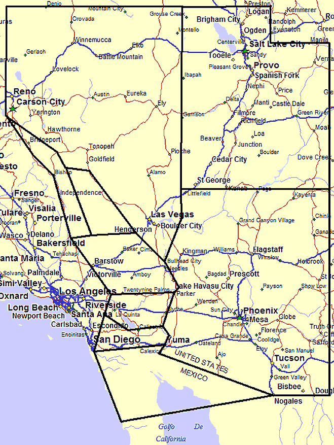
    Desert Peaks Bitmap - click in a black-outlined region!
    Map exported from TOPO! software, used with permission.

    01 - Trans Sierra 02 - Death Valley 03 - San Bernardino 04 - Riverside County 05 - San Diego and Imperial Counties 06 - Nevada 07 - Utah 08 - Arizona 09 - Mexico

    Click on the map above, or the list of regions below.

    Regional links below will show peak details and GPS data, plus topo and Google maps.

    click for full detailsclick for map view
    Region 01 Trans Sierra 14 peaks Google Maps or Google Earth
    Region 02 Death Valley 22 peaks Google Maps or Google Earth
    Region 03 San Bernardino 16 peaks Google Maps or Google Earth
    Region 04 Riverside County 12 peaks Google Maps or Google Earth
    Region 05 San Diego and Imperial Counties 4 peaks Google Maps or Google Earth
    Region 06 Nevada 15 peaks Google Maps or Google Earth
    Region 07 Utah 3 peaks Google Maps or Google Earth
    Region 08 Arizona 9 peaks Google Maps or Google Earth
    Region 09 Mexico 4 peaks Google Maps or Google Earth