Desert Peaks - Region 9
Mexico
Generated on 5 Aug 2021 - see revision history - please send updates to the webmaster
|
Mexico sorted numerically on Num column | ||||||||||||||
| Click on the peak name for similarly named peaks in a statewide peaks database. | ||||||||||||||
| click on these headings to sort by that column | click on these headings for more info | |||||||||||||
| Num | Peak Name (more links) | Waypoint | Elev | DPS | Class | Pics and Reports | UTM hint (map) | 7.5' USGS topo quad | Register | |||||
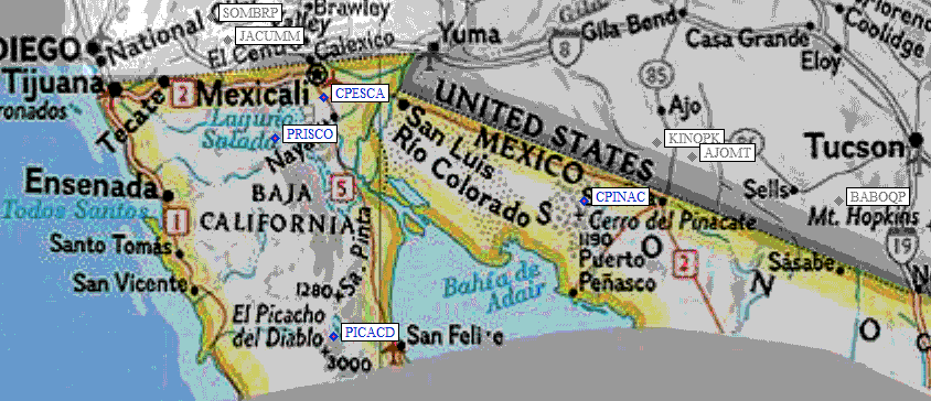
| 9.1 | Cerro Pescadores | CPESCA | 3543+ | 2 | 463820 | Sierra Cucapa | ||||||||
| Cerro Pescadores is the DPS name for the point in the Sierra Cucapa at 32°20’N, 115°21.7’W, about 20 miles south of Mexicali. It is 1.5 km SE of benchmark Puerta. | ||||||||||||||
| 9.2 | Pico Risco | PRISCO | 4987+ | 3 | 123557 | Arroyo del Sauz | ||||||||
| Pico Risco is the DPS name for the prominent point that is 2.9 km SW of the resort of Cańon de Guadalupe. The peak location is 32°08’N, 115°48.5’W. | ||||||||||||||
| 9.3 | Picacho del Diablo | PICACD | 10171+ | E | 3 | 6 reports on diablo | 552297 | Santa Cruz | ||||||
| El Picacho del Diablo is usually called 'Big Picacho' by the DPS. It is also named Cerro de la Encantada. It is at 30°59.6’N, 115°22.5’W. It is NOT named on the topo. It is not the Picacho el Diablo that is 7.6 km to the NW near the observatory, nor is it the Pico del Diablo 4.5 km to the south. The code number of the map San Rafael is H11B45. The map to the NE is useful for driving; it is H11B46, Santa Clara. | ||||||||||||||
| 9.4 | Cerro Pinacate | CPINAC | 3957 | 1 | 1 report on pinacate | 634177 | Volcan el Elegante | |||||||
| Cerro Pinacate is at 31°46.5’N, 113°29.5’W. It is shown on the US Sectional Aeronautical chart, Phoenix, as a prominent unnamed point with an elevation of 3957’. It is also unnamed on the Mexican topo with an elevation of 1200+ meters. The code numbers for the auxiliary topos are H12A22, Sierra Blanca, and H12A23, Los Norteńos. | ||||||||||||||
NOTE: M = Mountaineers Peak, E = Emblem Peak, X = not on DPS List (in 'DPS' column)
      ^ = metric contours and elevations on 7.5' maps (in 7.5' map columns)
      Name Mt  => 'Mt' is before peak 'Name' (ex: Rose Mt is Mount Rose, but sorted on 'Rose')
      Name Mtn => 'Mtn' is after peak 'Name' as listed (ex: Muah Mtn is Muah Mountain)
The "UTM Hint" in the table above approximates the peak location to the nearest 100 meters.
Click here for info on Universal Transverse Mercator coordinates.
Useful Links: