Desert Peaks - Region 6
Nevada
Generated on 5 Aug 2021 - see revision history - please send updates to the webmaster
|
Nevada sorted numerically on Num column | ||||||||||||||
| Click on the peak name for similarly named peaks in a statewide peaks database. | ||||||||||||||
| click on these headings to sort by that column | click on these headings for more info | |||||||||||||
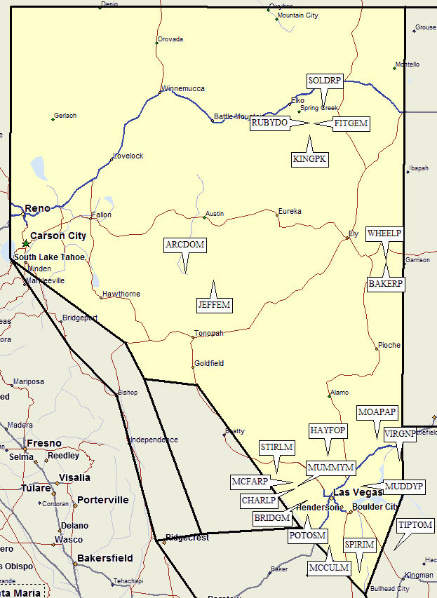
| Num | Peak Name (more links) | Waypoint | Elev | DPS | Class | Pics and Reports | UTM hint (map) | 7.5' USGS topo quad | Register | |||||
| 6.1 | Ruby Dome | RUBYDO | 11387 | 2 | 4 reports on ruby | 290977 | Ruby Dome | |||||||
| 6.2 | Wheeler Pk | WHEELP | 13063 | 1 | 4 reports on wheeler | 328184 | Wheeler Peak | |||||||
| 6.3 | Arc Dome | ARCDOM | 11773 | 1 | 2 reports on arc | 694981 | Arc Dome | |||||||
| 6.4 | Jefferson Mt | JEFFEM | 11941 | 1 | 2 reports on jefferson | 064891 | Mount Jefferson | |||||||
| 6.5 | Hayford Pk | HAYFOP | 9912 | 1 | 1 report on hayford | 609582 | Hayford Peak | |||||||
| 6.6 | Stirling Mt | STIRLM | 8218 | 1 | 1 report on stirling | 925345 | Mt Stirling | |||||||
| 6.7 | Charleston Pk | CHARLP | 11915 | E | 1 | 4 reports on charleston | 172147 | Charleston Peak | ||||||
| 6.8 | Mummy Mtn | MUMMYM | 11528 | 2 | 2 reports on mummy | 213178 | Charleston Peak | |||||||
| 6.9 | Potosi Mtn | POTOSM | 8514 | 2 | 2 reports on potosi | 352810 | Potosi | |||||||
| 6.10 | McCullough Mtn | MCCULM | 7026 | 1 | 1 report on mccullough | 650412 | McCullough Mtn | |||||||
| 6.11 | Spirit Mtn | SPIRIM | 5639 | 2 | 1 report on spirit | 071057 | Spirit Mtn | |||||||
| 6.12 | Moapa Pk | MOAPAP | 6471 | 3 | 1 report on moapa | 273820 | Moapa Peak | |||||||
| 6.13 | Virgin Pk | VIRGNP | 8071+ | 1 | 1 report on virgin | 584545 | Virgin Peak | |||||||
| 6.14 | Bridge Mtn | BRIDGM | 6988+ | 3 | 1 report on bridge | 349994 | La Madre Spring | |||||||
| Bridge Mtn is the high point of the massif named 'Bridge Mountain', not the spot elevation 6460’. | ||||||||||||||
| 6.15 | Muddy Pk | MUDDYP | 5387 | 3 | 1 report on muddy | 072193 | Muddy Peak | |||||||
| Muddy Pk is not the high point of the Muddy Mountains; it is the 'Muddy Peak' named on the topo which is 1.1 miles to the east. | ||||||||||||||
| 6.16 | McFarland Pk | MCFARP | 10742 | X | 1s3 | 1 report on mcfarland | 144224 | Charleston Peak | ||||||
| Most of the hike from the cars is on trail, there is a Class 2-3 chute below the Class 2 summit. | ||||||||||||||
| 6.17 | Baker Pk | BAKERP | 12298 | X | 2 | 1 report on baker | 325166 | Wheeler Peak | ||||||
| 6.18 | King Pk | KINGPK | 11034 | X | 2? | 298816 | Franklin Lake NW, NV | |||||||
| 6.19 | Fitzgerald Mt | FITGEM | 11215 | X | 2 | 1 report on fitzgerald | 346959 | Ruby Dome, NV | ||||||
| 6.20 | Soldier Pk | SOLDRP | 10089 | X | 2? | 456151 | Soldier Peak, NV | |||||||
NOTE: M = Mountaineers Peak, E = Emblem Peak, X = not on DPS List (in 'DPS' column)
      ^ = metric contours and elevations on 7.5' maps (in 7.5' map columns)
      Name Mt  => 'Mt' is before peak 'Name' (ex: Rose Mt is Mount Rose, but sorted on 'Rose')
      Name Mtn => 'Mtn' is after peak 'Name' as listed (ex: Muah Mtn is Muah Mountain)
The "UTM Hint" in the table above approximates the peak location to the nearest 100 meters.
Click here for info on Universal Transverse Mercator coordinates.
Useful Links: