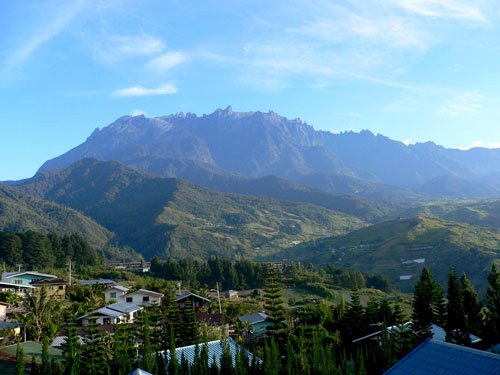
It's not often that a business trip turns out to be a lot of fun. Every once in a while you get to layover a weekend somewhere interesting and have an opportunity to get out and explore instead of the usual monotony of airports, hotels, and conference rooms. Well in April I had to spend a week in Kuala Lumpur, Malaysia before spending the following week in Japan. I decided to hit the web and find the tallest peak I could find in the area. I'd done Mt. Fuji last year on a similar layover in Japan, so I opted to find something close to Kuala Lumpur were I could find a cheap round trip ticket and be back in time for my connection to Japan. Well a quick search on www.summitpost.org came up with Low's Peak on Mt. Kinabalu, and it was in Malaysia! So I thought, Hey, I might be able to even rent a car." Well a quick geography lesson taught me that the nearest city to Mt. Kinabalu is Kota Kinabalu in the province of Sabah. A quick check of my map and I find that it's over a 1000 miles to Kota Kinabalu and that it was on the island of Borneo! Well luckily, Air Asia just opened a terminal in Kota Kinabalu and a round trip ticket was only $135 US so the hike was on.
I quickly find out this is a popular destination as Kinabalu Park is a United Nations Educational, Scientific and Cultural Organization (UNESCO) World Heritage Site and is protected by the government. Access is very limited. No camping is allowed in the park, so all visitors must reserve accommodations. Four emails in two months to the reservations office got me no where and I found myself in Kuala Lumpur without any firm plans! However, I did remember there was a sales office in Kuala Lumpur for the company managing the park, so I walk over one afternoon, in the rain, to the office. As usual in Asia, people are incredibly helpful and friendly and a quick phone call got me a bunk bed in the hostels at the parks central complex and at the mountain hut.

I finished up my work on a Friday and got on my flight to Kota Kinabalu. Catch the bus from the Airport to the towns' central bus station for 1 Ringgit (33 cents). I then find that I need a bus to Ranau, which leaves from a Mendaka park 3 blocks away. The Ranau bus stops outside the park. Well I march off with my backpack and rolling suitcase and I arrive soaking wet. My Canadian blood isn't thin enough for the tropics and it was hot and humid. I later found out April is the dry season. Ya Right!It rained every day. I think they meant it's less humid. Now I find my bus..., well that's what they called it. It was two guys and a Toyota minivan with 11 people and luggage stuffed in it. That may sound like a lot, but you have to remember the Malaysians aren't large in stature as a race of people, and there were lots of kids.! Whoowho!
My timing was great as the afternoon rains started and I was inside at least. The price was great, only 20 Ringgit ($6.75), so I thought it would be a short ride. 2 hours later, we arrived at Kinabalu Park. I must say, the driver was amazing. He slid the van through the corners in the rain and passed trucks on a two lane road with no visibility around blind corners overlooking spectacularly beautiful cliffs that seem to fall away into a infinite abyss. I think Michael Schumacher would have been impressed. I found closing my eyes and praying helped! My new best friend Nia, from England, found exclaiming "Oh God!, Oh God!, Oh God!" at every turn worked for her. Same thing I guess. The locals sure thought it was funny. The kids were all laughing at her. Getting to the mountain is half the fun... right?
A short walk in the rain and I was at the park. $15 Ringgit to enter and I find the reservation office and get my bunk bed assignment and then walk the 15 minutes down the road, still in the rain, to my luxury accommodation. I bought the package deal, so all meals, lodging, climbing fees, permit fees, personal guide fees, non-Malaysian fees, insurance fees, and my certificate fee, were all included (483 Ringgits). After stowing my gear I headed to the common room where I hoped to try out in front of the fire, I met James and Bob, two local Malaysian gentlemen who do pest control around the facilities. I'd mention it must be nice to work in a beautiful park like this from time to time and learned they live there? I guess there have lots of bugs! I also learned that everything in Malaysia is now owned by the Chinese, Indians, Japanese, and that Malaysians basically get screwed and live in poverty. Nothing like a little local color!

Around dinner time, I'd dried out, the rain stopped, and after I'd gotten a great lesson in Malaysian socio-economics, it was time to head to the Balsam Cafe for the buffet dinner. The food was great; lots of local fruits and vegetables. Lot's of spicy noodle dishes. The service was wonderful and the waitress was always smiling. My only recommendation is just stay away from meat in Malaysia. I don't know where it comes from, but the chicken and beef taste the same and the consistency always seems to be like I left my beef jerky in the rain? There are lots of other great foods, so just go vegetarian. I met lots of folks from all over the world. Nia was there; she'd been bopping around Borneo for 7 months.. There were also a couple of young climbers from Austria, a couple from Korea, and Dorette from Denmark. She was a fitness instructor and I later learned her name was the Danish form of Dorothea which means "Gift from God". How appropriate. Meeting folks from other places is always a lot of fun. I turned in early as I new the next couple days were going to be fun. The website said the climb was 2200 up and 8.7 long. That didn't seem so bad.
The next morning I went back to the cafe for the breakfast buffet, picked up my sack lunch for the climb, and met my guide at the climbing office at 7am. A short shuttle ride (part of my climbers fee) and we were at trailhead at Timpohon Gate. There is a nice viewing deck behind the gate where you can get a good view of the mountain. It was about this time that I realized the 2200/8.7 was metric and my little engineers brain went into over drive and I realized I was in for a lot more fun than I'd anticipated. A climb of 7283ft/5.4 miles was my conversion. "Oh Crap", It's Whitney's North Fork, but worse. And I used the "Danish" word for crap!
By the way, Timpohon Gate is really a gate. You have to have a plastic ID badge to get passed. All climbers passing the gate must wear a badge. It's got a nice photo of the mountain on the front with the text,"Welcome to Mt. Kinabalu, Take nothing bug photographs and leave nothing but footprints". You get to keep it too. It's a nice keepsake from you trip. It looks great next to my certificate! After the hike I looked back at the "Welcome to Mt. Kinabalu" part and had the ironic thought that it was a lot like the "Welcome to Canada" sign painted on the cement wall at the exit of the fastest chicane at the Canadian F1 Grand Prix where everyone crashes spectacularly.


The start of the hike was down hill. Already I'm thinking about all those feet I'm going to have to climb back up. Even worse, tomorrow I'll have climbed 3000ft to the summit and descended 7300ft and I'm going to be rewarded with the last 1Km being up hill. It was about this time I really started to see the jungle and my attitude improved. The waterfalls are spectacular. Water is everywhere. The plants are all lush and deep green and the flowers are amazing deep red, yellows, and pinks. It really is an amazing place... even though it was raining again.
After a short bit of climbing we found ourselves above most of the lower rain clouds but still below the clouds surrounding the summit peak. The trails were remarkable easy given that the rain rips them apart so regularly. They have harvested tons of local teak wood and made treadles all over the place to hold up the trails. In the Sierras you have lots of trail dust, sand, scree, but here it's just gravel, stones, boulders and red clay mud. Everywhere you look you see examples of fungi, pitcher plants (Nepenthes Villosa), birds, and succulent flowers. Some flowers span 3-4 feet.

One thing I really loved about this trail were the signs every 1-1.5Km with a map and a dot exclaiming,"You are here". It gave me a great sense that I wasn't lost and it validated my feeling that I was moving much slower than usual. I'm a comfortable 1.5 2.0 mph hiker and I was averaging about 1 kmh! I figured the heat and humidity would slow me down, but Wow! The second thing I loved about this trail is that they didn't waste resource and time cutting switchbacks into the trail. It seems they have a great love of this ecosystem and wanted to cut down as few trees and shrubs as possible. The trail goes straight up.
Another item worthy of mentioning is the design of the steps cut into the hillside. Steps are 10 - 20 inches tall! I can only guess that the trail builders saw themselves as giants among men because the locals weren't that tall, but the steps were huge. My old trick of taking small steps to save my poor thigh muscles just wasn't working.

I'm not sure if it's planned this way, but about the time you thighs really start to burn and you've sweated out your first liter of water, the restaurant porters show up. These guys and gals carry all the supplies for the mountain huts and restaurant at Laban Rata, our destination for the day. Young porters carry 35 Kilo loads in a basket with straps over their shoulders. Nobody had load levelers or a good padded hip belt. Much lower tech than I would have imagined. The seasoned veterans carry up to 50 Kilos! The calves on these guys with wider than my thighs.
It seems mules and horses are not well trained enough to use the toilets at every rest station so they have to use people. I told you they keep this place clean! You can't go run off an pee in the bushes. Either that, or people work for less money. My guide gets 100 Riggit's for taking a group to the peak. That's $30US for two days work. And my 6' 1" son bitches about having to drag the trash cans 1200ft up my driveway and they are on wheels! I'm lowering his allowance. The low point of the day was watching a woman around my age about 5' 2" tall go flying past me smoking a cigarette with the biggest pack I've ever seen. I felt wiped. I think we've forgotten how to work hard in this country. Anyway, I thought the toilet thing was interesting. Every station had one. I drank 6 quarts in 7 hours and never had the need to avail myself of the facilities. It took 2 more quarts at the mountain hut and 2 more beers. That reminds me, beer is really expensive at the mountain hut. The porters only bring up cans. They're to wimpy to lug up a keg!
The lower part of the trail is very different that the sections higher up. You are in a jungle with a tall canopy. You can't see much except flora and fauna and you don't get a sense of where you are and how far you have come, except for those wonderful aforementioned signs. As you progress up the trail you work your way into a section that is covered in large chaparral like shrubs. It's not a dry area, but all the tall trees disappear. This is where I got my second wind. You can see the mountain, and you can feel you progress. There's something about being able to see mountain that makes you legs keep moving. It's kind of like the carrot in front of the horse I guess.
After about 7 hours of climbing we
had made it to the 6 Km sign post and had
arrived at the Laban Rata mountain hut. I checked in and was
assigned a heated room. I'd recommend the heated room. Some
of the other climbers were very cold in the unheated
rooms. You get a blanket and a sheet, so you might find yourself
sleeping in your cold weather gear otherwise. I was told the
temperature drops about rapidly as you gain altitude in the
tropics. Something to do with a much steeper humidity gradient as
you gain altitude. Once we left the protection of the
dense jungle trees, the wind chill was very noticeable and we started
putting on layers.

")
Where did the jungle go? As we approach the Laban Rata mountain hostel you get amazing views of the upper mountain if the weather cooperates. The climbers we passed on our climb had all climbed to the hut in the rain and were rained out on the peak and had to turn around at the mountain huts. Just like here in the Sierra's you have to get an early start and hit the peak around sunrise to have even a chance of getting a view and avoiding the rain. After a quick shower and a meal, I took some pictures and headed off the bed around 7pm. My guide Kuinten suggested we leave around 2:30am to reach the peak at sunrise. One additional note about reaching the mountain hut. The climb is actually steepest, just before you get to the hut!
Our early AM start was pretty easy. I must admit between jet lag and the long climb I was whacked at 7pm and was out like a light. I was up at 2am, got my 7 hours of sleep, grabbed breakfast and we headed off to the peak. With the exception of forgetting my headlamp in my suitcase everything went swimmingly. Kuinten had a spare and saved the day. There was a half moon out for our start which allowed us to see a little. It wasn't enough to get any good pictures, but as we climbed out of the shrub brush and onto the granite slopes, you could see off towards the coast and the moon was reflecting off the ocean and the starts were as bright as I've seen on the high peaks of the Sierra. The bad luck of the folks the previous day had bought us a clear cloudless morning as we climbed to the summit.
Once you climb an initial steep 200 meter section you gain the upper slabs of the granite dome and things become quite a bit easier. The only difficulty on this section is that you are on granite slabs and have to use a nylon rope to pull yourself up in sections and to give yourself some extra safety as you have to cross a few section of wet mossy granite with some exposure below. There is a final summit checkpoint at 12,100ft (3688M) called Sayat CP where they check you badge and register your guide and allow you access to the upper section of the mountain. This is also the station where you can let them know if you'd like you certificate stating you made the summit. They attendant will radio your information to the climbing office and they will have a certificate waiting for you when you arrive. This section of the mountain is a lot like walking the area around Half Dome in Yosemite. Just solid granite everywhere. What's very different are the formations in the granite. I'd never seen anything like them. It's not polished like we see in the Sierra, but it's almost like it's been pressure blasted by water.

Huge slabs of granite are being broken off by constant freezing ice storms up here. They killed a 17 year old British girl in 2007. Then the constant flow of water moves them down slope then off the edge of the dome.

Kuinten had mention that there have been times where a sudden rain storm has cut off the route back down to Laban Rata. These huge sheets of granite collect the torrential tropical rain storms and they funnel into only a few gullies. One of these gullies passes right next to the Sayat checkpoint hut. It's basically an instantaneous flash flood that can be a few feet deep and rushes right over the edge of the dome. The pictures a show the gully past the Sayat checkpoint (left) and a gully down the other side of the dome (right).
The long walk up the slabs wasn't difficult at all because we had good weather and clear sky's. The long continuous rope wasn't needed except in a few areas, but I could see from the weather later in the day that rain and fog can descend on the peak and your visibility drops to 20-50ft. Many climbers have had to use the rope just to find their way back. The few people who have died on this peak have lost their way on the rope and headed off the edge of the dome or down the wrong gully. There is no use trail across this area. Even following the rope in the dark required paying constant attention. It's very easy to wonder off and lose track of where it runs. The actual summit peak (above left) requires a little scrambling and there is a nice sign at the top so you can grab a quick photo for your album.

The wind chill on this day was very cold and the weather was good. There were many climbers that got to the summit too early and had to wait 1-2 hours in very cold conditions for sunrise. Not many had gloves, hats, or enough layers to keep warm. Many were heading down before the sunrise which was a shame.

I hung around for about 30 minutes and decided to get moving again to warm up. Heading down was actually the hardest part of the entire weekend. We still had 3000ft down to the mountain hostel for breakfast and another lunch sack. Then we had the rest of the 4300ft to go and all those steps again. with over 10,000ft of elevation change in one day, I can officially claim that this was a new personal best for me! I saw a lot of climbers in really bad shape with blisters from their toes being jambed into their shoes and even more who had just plain bonked. One overweight 50-something guy from the US was carried down from one of the mountain stations by a porter! The guy being carried was easily 200lbs! I hope he was a big tipper. I can say personally that my legs were sore for the next 4 days. The final 1000ft of the decent I was in the rain, exhausted, and holding onto railings and trees to help stabilize myself as I stepped down one more step. The last uphill section back to Timpohon Gate that I was dreading actually was a blessing in disguise. Going up, I was able to use my back and my butt muscles and let my thighs have a rest.
