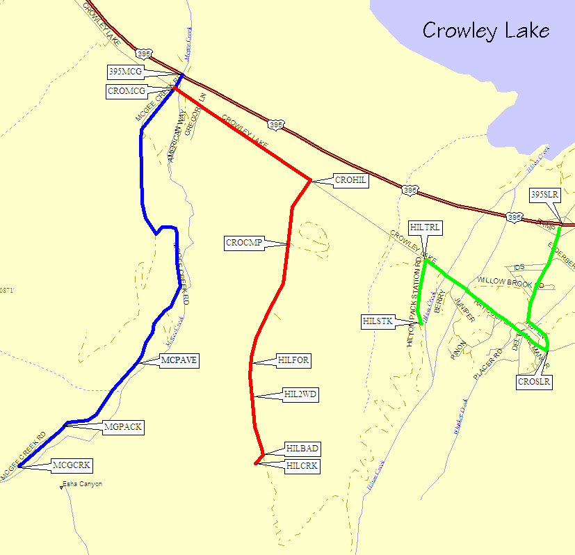
McGee Creek and Hilton Creek
Revised 11 Jun 2012 - please send updates to the webmaster
Both Hilton Creek (red line) and McGee Creek (blue line) drain into Lake Crowley. These two creek drainages are separated by one of the Mt Morgans (the other Mt Morgan being only a few miles to the southeast, on the other side of Rock Creek). Contrary to instructions found in other places, you should NOT leave Hwy 395 at Crowley Lake Road for these trailheads - leaving Hwy 395 at McGee Creek Road is shorter to McGee and faster even to Hilton. Turn southwest from Hwy 395 at McGee Creek Road (waypoint 395MCG) for both trailheads.
NOTE: There is a separate (lower elevation) stock trail for Hilton Creek (green line) - see below for a description that DOES leave Hwy 395 on South Landing Road, described by some as the Lake Crowley exit, which is about 3 miles south of the McGee Creek Road intersection. Crowley Lake Dr actually crosses Hwy 395 to the north of these intersections, and generally runs parallel to the highway.
NOTE: This McGee Creek is not the same as the
McGee Creek in Buttermilk Country
used to climb Basin Mtn! This one is by Mt Morgan.
Leave Hwy 395 on McGee Creek Road (waypoint 395MCG), about 6.5 miles
north of Tom's Place (Rock Creek). Other reference points include
30 miles north of Bishop, 9 miles south of the Mammoth Lakes turnoff,
or 34 miles south of Lee Vining.
Continue across Crowley Lake Drive (waypoint CROMCG) at a 4-way
stop sign. Pass the McGee Creek Campground (signed 'camp only in
designated sites'). The pavement then ends (waypoint PAVEND) but
the road remains good for all cars. There is a gate (waypoint MGPACK)
where the road apparently crosses onto pack station property - open
the gate and drive on through! There is a public pay phone just inside
the gate, but parking in this area is for pack station clients only.
The McGee Creek trailhead (waypoint MCGCRK) has a large paved lot
that horse trailers dump crap on, an outhouse, and several picnic
tables where you may be able to spend the night. One such table is
at the lower end of the parking lot, on the side away from the creek.
Another is just beyond the trailhead sign, on the creek side of the trail.
There are two trails leaving directly from the trailhead sign.
The upper one is from the pack station, and is actually the
better trail. The lower one remains level for a ways and then
switchbacks up to meet the higher one.
NOTE: This trail goes up Hilton Creek to Hilton Lakes, then back
down to Rock Creek Road and the Hilton Lakes Trailhead.
Leave Hwy 395 on McGee Creek Road (waypoint 395MCG), about 6.5 miles
north of Tom's Place (Rock Creek). Other reference points include
30 miles north of Bishop, 9 miles south of the Mammoth Lakes turnoff,
or 34 miles south of Lee Vining.
Turn southeast (left) at Crowley Lake Drive (waypoint CROMCG) at a 4-way
stop sign. About 1.1 miles south of this stop sign, turn uphill (right)
at Hilton Creek Road (waypoint CROHIL). There is a large wooden sign
here reading 'Crowley Lake Recreation Site'. If you have pack stock, go
further south to the road called Hilton Creek Trail (waypoint HILTRL),
described in the stock trail for Hilton Creek
section of this file.
From waypoint CROHIL, it's all uphill on an increasingly bad dirt road.
The main road goes left into the Lake Crowley Campground (at waypoint CROCMP),
but there is a small wooden sign indicating you should go straight to reach
the Hilton Lakes Trail. Keep going straight uphill, past all the turnouts
and the occasional camper-for-life site, past the National Forest Boundary
sign (waypoint HILFOR) where the road gets noticeably worse, and think
about stopping at the large parking area at 7500' (waypoint HIL2WD).
2WD passenger cars can easily get here, where a 4WD side road goes west
and the trailhead road continues south.
Waypoint HIL2WD is a good place for passenger cars to stop because
there won't be a good place to turn around or park until after the
really bad section (above waypoint HILBAD) where a corner leaves you
looking a big rocks and deep ruts. Near where the bad part starts,
there is parking for 1 or 2 cars only. Above the bad portion there
is another small parking area (marked by a sign) and a short walk to
the gate where the trail actually starts (waypoint HILCRK) at 7800'.
NOTE: Hikers will probably want to use the other
Hilton Creek Trailhead, described above!
Leave Hwy 395 on South Landing Road (waypoint 395SLR), about 3.8 miles
north of Tom's Place (Rock Creek). The sign here says Crowley Lake is
south (toward the mountains), referring to the TOWN and not the LAKE,
and says Hilton Creek is north (toward the valley, where the actual
Crowley Lake is). Other reference points include 27 miles north of
Bishop, 12 miles south of the Mammoth Lakes turnoff, or 37 miles
south of Lee Vining.
This major interchange leaves you on a sort of main street through
town, with a small general store and other services. Go uphill and
stay on the main road as it starts to wind, then hit a 'T' intersection
with Crowley Lake Dr (waypoint CROSLR). Turn right (northwest) on
Crowley Lake Dr and go about 0.8 miles (just north of the fire station)
to a dirt road going uphill (waypoint HILTRL) with a street sign
saying 'Hilton Creek Trail'.
This dirt road forks and ends at waypoint HILSTK: the left fork
is marked 'Parking', the right fork is marked 'Trailhead'.
This trailhead is about 700' lower elevation than the
Hilton Creek Trail described above,
but they do appear to meet higher up (according to the map).
Useful Links:
GPS Route MCGEE CREEK - blue line on the map above
GPS Route HILTON CREEK - red line on the map above
GPS Route HILTON STOCK TRAIL - green line on the map above