Kofa Wildlife Refuge Peaks
(Signal Peak and Castle Dome Peak)
Revised 6 Mar 2014 - please send updates to the webmaster
Below are trailheads for:
- Signal Peak
- Castle Dome Peak
These are very short hikes, and both peaks can be done in one day.
See this 2009 trip report for more.
|
It's a long drive from anywhere. Anywhere except Yuma. Which may
explain why most of the summit register entries are from Yumanites.
Yuma is the closest airport, halfway from San Diego to Phoenix,
but Phoenix isn't much further and would be much cheaper.
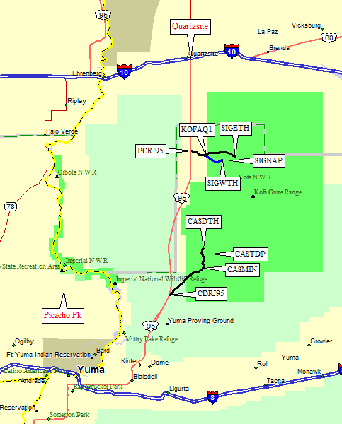
The two peaks described below are just off US Hwy 95, between
I-10 and I-8. (That 'US' is important, because there's also an
Arizona 95 that runs parallel to US 95 on the north side of I-10.
US 95 follows the route of I-10 between Blythe and Quartzsite
and goes north from Blythe, while AZ 95 goes north from Quartzsite.)
So find your way to US 95... ignoring, if possible, the complex instructions in the DPS Guide and realizing, if possible, that road signs will direct you between these two major highways. (OK, it's not a simple cloverleaf, but it's not worth a paragraph.) Exact mileage on US 95 doesn't matter. There are only two turns marked with brown Kofa Refuge signs between I-8 and I-10, one for Signal (20 miles south of I-10 and 30 miles north of Castle), and the other for Castle (20 miles north of I-8 and 30 miles south of Signal). If you want a side show be sure to stop in Quartzsite to view thousands of Snow Birds flocking to roadside stands and living the good (but dusty) life. It's the greatest concentration of this migratory group that either of us had ever seen. |
|
Look for a brown-and-white sign on US 95 about 20 miles south of I-10 (or 50 miles north of I-8) that says Kofa National Wildlife Refuge. Turn east at that sign onto Palm Canyon Road (waypoint PCRJ95). It's very rough washboards and dirt, with some erosion cuts in the roadway, but easy for passenger cars. By the way, the King Of Arizona mine (aka 'KofA') gave this area its name - Signal Peak has USGS benchmarks at the top labelled KOFA, not SIGNAL.
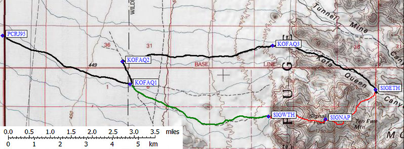
At waypoint KOFAQ1 (about 3.5 miles from US 95) there's a big info board and a left turn sign that says 'Kofa Queen Canyon 5 miles'. People camp here and all along the road. Go past the 'host' in a motorhome (it looks like the road leads to their campsite, but goes right by them). It's all 2WD, but the road narrows near the sharp corner at KOFAQ2 (4 miles from US 95). Reasonably high clearance would be advisable for the ruts (center hump).
Beyond KOFAQ3, where there's a rough spot about 8 miles from US 95, you either need 4WD or guts and high clearance. The road drops into the Kofa Queen Canyon and there is more sand and high rocks. There is a camping area on the right just east of KOFAQ3 with flat parking and fire rings. It seems pickup campers are fond of this valley, and by late March the flowers would probably be great. The campsite turn is easy to identify during the day, but we mistakenly took that turn instead of going straight at night.
The black line on the topo map is a GPS track log, which was used for the mileage measurements in this file. Notice that it doesn't follow the line on the USGS topo, and realize that the roadbed changes from year to year. There are braided sections where we took different branches on the way in and out. Just stay in the wash until Ten Ewe Canyon.
The climbing route goes south into a drainage fed by both Ten Ewe Canyon and Indian Canyon, and stays in Indian Canyon when they split. A few feet down-canyon from the mouth of the drainage (waypoint SIGETH, just under 11 miles from US 95) is a nice place to camp. It's flat sand and you can get many vehicles out of the travel path here. Don't look for a parking lot, don't sleep where someone can drive over you, and don't block the road!
This eastern trailhead (SIGETH) puts you about 1.5-2 hours from the summit over mostly class 2 terrain (with one or two easy class 3 moves if you don't try hard to avoid them). There is also a western trailhead (SIGWTH) but that waypoint is approximate - I didn't visit it because the routes are much harder and the tourists are much thicker there. Lots of people pound up and down these gravel roads on weekends. The scenery in Kofa Queen Canyon is well worth the 4WD road to get there.
Look for a brown-and-white sign on US 95 about 20 miles north of I-8
(or 50 miles south of I-10) that says Kofa National Wildlife Refuge.
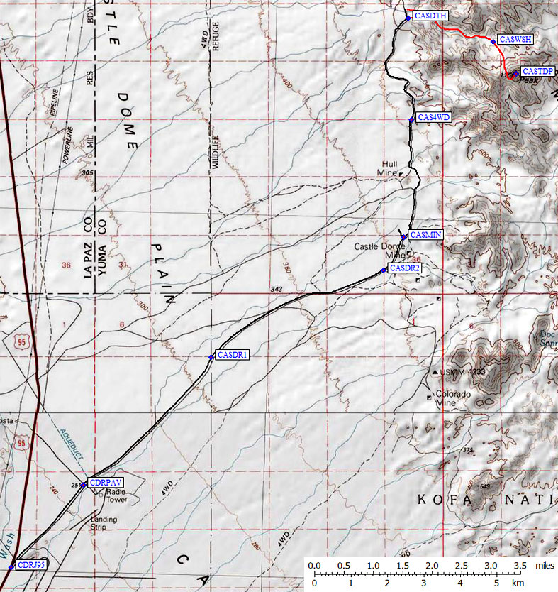
Turn east at that sign onto Castle Dome Mine Road (waypoint CDRJ95).
This road is paved for a short distance, until the turnoff to a
"Restricted Area" on the right (at waypoint CDRPAV, 2 miles from US 95).
The black line on the topo map is a GPS track log, which was used
for the mileage measurements in this file.
There will be a sign for the Kofa National Wildlife Refuge boundary
(waypoint CASDR1), keep going on the washboarded and heavily
travelled dirt road. There is marked turn to the McPherson Mine
(at waypoint CASRD2). The DPS Guide mentions the Hull Mine, but
in 2009 we saw no signs for that one. There is, however, a STOP
SIGN and a big advertising sign for the Castle Dome Mine (at
waypoint CASMIN, 9 miles from US 95 and not mentioned in the DPS Guide).
Go straight unless you want to visit their museum (closes at 5pm,
and they said they had no facilities or water).
Past the museum, the road deteriorates but could still be done
in a passenger car. For a while. Waypoint CAS4WD (11 miles from US 95)
marks the start of high clearance (crossing washes with sharp edges, etc).
Within a mile of CAS4WD there are a couple of primitive campsites
where people have parked on flat ground and built campfire rings.
It must be OK, since the fires could be seen for miles!
The road drops over a low shoulder and improves somewhat. Maybe
it goes all the way to Palm Canyon Road (see above) but we did
not check that. 13.5 miles from US 95 there's a sharp corner in
the road which is not shown on the USGS maps. Stakes and a fire
ring mark a good place to camp, and we used this as our trailhead
(waypoint CASDTH). The DPS Guide has you drive another quarter mile,
but there's less room to park there and the ground is less friendly
for camping. You can walk up the wash from either parking place.
Useful Links:
Castle Dome Peak