Bairs Creek and George Creek
(cross-country trailheads for Mt. Williamson)
Revised 11 Jun 2012 - please send updates to the webmaster
See this popup local area map showing Big Pine south to Lone Pine (look for waypoint INDEPN).
The Onion Valley trailhead route leaves Hwy 395 at the same place.
Mt Williamson is also climbed via Shepherd Pass, which has a trail!
View the waypoint file (above) for GPS Routes BAIRS CREEK,
GEORGE CREEK,
and HWY 395 BIG PINE TO LONE PINE.
WARNING: Bears have been seen at low-elevation trailheads in this area (Shepherd Pass in particular) so don't assume your car is safe with food in it.
If possible, use these directions in conjuction with the AAA Eastern Sierra map.
As of February, 2002, this route was suitable for low clearence vehicles and was preferable over the route from Manzanar.
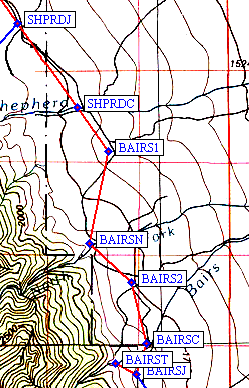
This route does entail crossing both forks of Bairs Creek (waypoints BAIRSN and BAIRSC),
and it is possible that these can be problematic if it is icy or there is a lot of run-off,
but even with the stream-crossings (which were icy for us), I found it to be the preferable route.
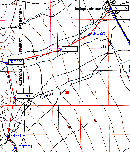
From Independence (waypoint INDEPN), take Market Street towards the Onion Valley trailhead.
This road turns into Onion Valley Road. After approximately 4.5 miles after leaving Independence,
turn left (south) onto Foothill Rd (waypoint INDEPJ). Foothill Rd is an improved gravel road
and is signed. After approximately 3.3 miles along Foothill Rd you will pass the turn-off to
the Symmes Creek/Shepherd Pass trailhead (waypoint SHPRDJ). At some point following this turn-off,
the road turns into a regular dirt-road, but should still suitable for low-clearence vehicles.
Five miles following the turn-off to Sheppard Pass, you will reach the main fork of Bairs Creek
(waypoint BAIRSC). There should be a sign identifying it. Keep driving south and when the road
forks about 1/2-mile or so past the creek (waypoint BAIRSJ), stay right and continue about
another 1/2 mile or so to the trailhead at the end of the road south of Bairs Creek near the
mouth of the canyon (waypoint BAIRST). As of February, 2002, this route was suitable for low
clearence vehicles.
Note: This route does entail crossing both ! forks of Bairs Creek,
and it is possible that these can be problematic if it is icy or there is a lot of run-off,
but even with the stream-crossings (which were icy for us), I found it to be the preferable route.
People often approach George Creek from the Manzanar area, but the topo maps show
these road locations as 'approximate' and some wandering around is common. If you
have GPS waypoints or a solid description of that approach, please sent it!
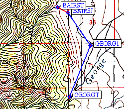
The way I last went to George Creek is to follow the description above to
Bairs Creek, except do NOT turn right at waypoint
BAIRSJ - instead, continue about a mile to the NEXT junction (waypoint GEORG1)
before turning right. Follow that road to the end at waypoint GEORGT.
Useful Links:Directions to Bairs Creek Trailhead
Directions to George Creek Trailhead