I was frustrated by a lack of solid info about a climb that has thousands of people on it every year, so please forgive my overuse of numbers in the report that follows. Also beware "the tyranny of a single data point", since conditions and weather patterns that we encountered may not be typical.
We had an overnight layover in Amsterdam and two nights in Tanzania before the climb. That was long enough for several of us to start having cold, flu, and GI tract problems... no surprise when you cross 11 time zones and eat unusual food after washing your hands with water that is unsafe to drink. (I know, the guides are fond of saying that all the water is just fine, but a bunch of us got sick anyway.)
Already popping Cipro pills, and after two nights in the Marangu Hotel (4700', waypoint MARHOT), we bounced up a very dusty road to the Machame trailhead (6200', waypoint MACHTH) where we all signed in and ate lunch. It was all uphill to the Machame Hut camp (10200', waypoint MACHAM) with some mud deep and sticky enough to remove Rebecca's shoe. (Did I mention she was hiking in running shoes because the brace around her stress-fractured-ankle hurt in hiking boots?)
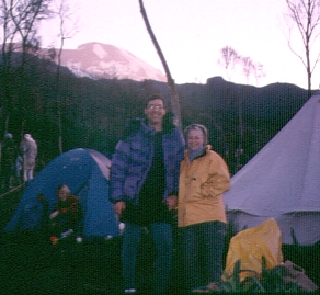
| One of our duffels showed up late to camp the first day, and we never saw that porter again. For the rest of the climb, our tent was up and our duffels were waiting by the time we got into camp. I had brought my own Sierra Designs expedition tent, wanting something more sturdy and roomy than the standard trekking tents Marangu provides, and it was always an adventure to see how the complicated poles were rigged since the porters had never seen a tent like this before. None of the "huts" on this route are what you could call climbing huts - they were used for cooking only by other groups, and we were seldom camped within sight of them. The first campsite was near treeline, and featured a stagnant pool of drinking water that made those who brought water filters glad we had them. My 4 micron pre-filter clogged every two quarts, and needed frequent backflushing, but did protect the main filter element. |
| Day 2 dawned damp but clear, and we headed up the steeper trail as the temps dropped and the clouds built in. By noon, our group was well spread out. Those of us at the back could no longer see the front when they stopped for lunch and hot tea, so my plan to light a Twinkie and have the whole group sing for my wife's birthday fell apart. By the time we reached camp (2:30pm) it was starting to sprinkle and my (unrefrigerated? 2 day old?) beef sandwich lunch was exploding in my gut, so I skipped dinner in what turned out to be the low point of the trip for me health-wise. I managed to drag myself out of the tent and present the "birthday cake" twinkies (with 39 wooden matches standing in for candles), but mostly tried to sleep it off. | 
|
Shira Camp is at 12800' (waypoint SHIRAH), but we hit 13000' that day as the trail popped up onto the plateau. GREAT scenery here, by the way, with scrub brush and moss on the rocks but no streams except the murky one in camp. The experts say you're supposed to gain 1000 to 1500 feet per day to avoid altitude sickness. We stayed at 4500', 10000', and then 13000'. People weren't feeling all that great, and we were looking forward with false hopes to an easier third day.
Day 3 saw us leaving camp as much earlier clouds started to form. Overnight temps had been in the 20s (F), and threading our way along sandy paths between volcanic boulders was a sharp contrast to the jungle that was behind us. The Cipro was working (both on my GI problem and my bronchial infection?), and I selected a spot near the back of the group to establish a plodding but sustainable pace. Rebecca had never been over 10000' before, so every step was a new personal altitude record... and an exercise in pacing herself.
Seamus had said there was a 15.5k pass, but I think it was more like 15k. Actually, there were two or three cold ridges to cross in the blowing fog-clouds, each adding to the day's gain, before we dropped steeply down to Barranco Camp at 13200' (waypoint BARNCO). Along the way we saw our only good clear-water stream of the trip, and I pumped a couple quarts of cold water as we relaxed in the sun before waking up the guide and finishing the day.
Day 4, and we're losing people. Betty had turned back after the first day, and now Leanne and Dixie were headed out via the Umbwe Trail - as much to avoid climbing "the wall" out of Barranco as anything else. The trail climbs steeply up a cliff face, looking very exposed from below, and there are one or two places where hands should be used. The maps are all wrong here, since the trail climbs in and out of valleys where the map shows a level traverse.
We did 1200' of climbing, 1400' of dropping, and wound up in the Karanga Valley (13000', waypoint KARANG) where our guide wanted to spend the night even though we had all paid extra for a layover day at high camp. Continuing up to Barafu Camp involved 2400' of additional gain and would take us over 15000', but staying in Karanga meant we'd have only half a night at high camp before the summit. We were told there was no place to camp between the valley and high camp, but that was not true. We walked by several areas that were flatter than our site at Barafu. Since all the water had to be carried up from the valley to high camp, stopping somewhere halfway up would have been easier on the porters.
But wait, there's MORE! The group voted to stay in Karanga Valley, as our guide requested, but someone in the other lunch tent started a stampede and we headed up the trail shortly after voting not to. I still haven't gotten anyone to tell me what happened in the other tent, but someone there should have a role in presidential politics! As an added bonus, it started raining just after we started walking, and the rain slowly turned into snow which accumulated on us and the ground as we lost sight of each other and plodded our way up the hill. Jeff stayed behind with altitude sickness, probably enhanced by a chest infection or the flu setting in.
| Enrique arrived at Barafu way before the rest of us, and was astonished to find the porters (some dressed in thin cotton, no gloves, bad shoes) huddled under rock outcroppings to stay out of the still-falling snow. The guides, needing them to set up camp, threw handfulls of dirt and snow up under the overhangs to drive out the porters. As our climbers arrived, several were hypothermic (one took her temperature to check, another just got thrown into his sleeping bag). We should have stayed in the valley. It wasn't a very fun afternoon, and the long day probably stopped a couple of people from climbing the peak. | 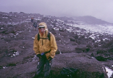
|
[Weinstein comments on this report: "I don't agree with your opinions or observations regarding staying at the Karanga valley. I believe the number of people who made the crater, and the relative health of those people (Ray aside), speaks for the correctness of the decision to respect our original itinerary, and the height of the mountain. In any case, most everyone seemed to enjoy the vacation and to complete it safely. In the final analysis, that's all that matters."]
| Day 5 was a layover day at Barafu (15300', waypoint BARAFU). Some people did an afternoon hike about 1000' higher, but most of us laid around in our tents. Some had headaches that lasted the entire time we were at high camp, the result of climbing too fast too soon. Others were having GI problems, and I think a few tossed it, but I just read my book and tried to keep drinking fluids. Jeff showed up after all, but didn't feel well even though his climb had been broken into two days. |
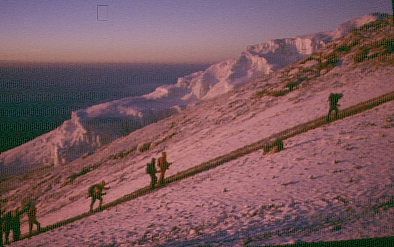
Summit Day! Up at 11pm, walking at midnight, our guides set a pace so slow that even the sick among us could keep up. They kept us in a tight group for quite a while, but as various people turned back each of them took a guide with them. Others who weakened had a guide assigned to them (carrying day packs, in some cases steadying them as they climbed).
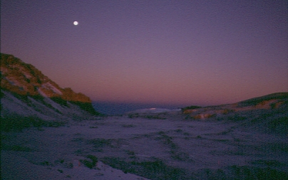
| As we climbed, it started to snow again: This was good news and bad news! It was far degrees warmer than just a few nights before, when climbers reported below-zero (F) temps, and the thin skiff of snow which collected on the ground reflected the full moon so we could see better. On the other hand, the wind and high humidity really made the 15F temp feel much colder. I had my baffled gore-tex down parka and expedition mitts on, and was not overly warm. This is the first time I've used chemical handwarmers in those mitts when it was above zero (F), and I've never buttoned up the down coat while climbing (not even on Denali's summit!). I was not at my best, still fighting off various ailments and afflictions, but pacing myself was easy on the mostly-dirt trail. |
|
| As dawn approached, we were within sight of Stella Point. The group took almost no rest breaks, but I was stopping on my own to fiddle with boots and gloves, and to tank as much water as I could. (Seamus said not to drink more than a quart, and we were provided nothing to eat for the 10+ hour summit climb, but I sloshed down 2 quarts of water and about 1500 calories of snacks brought from home.) A short sprint to the crater rim (waypoint STELLA) allowed some sunrise photos INTO the crater, plus a nice sunrise shot of the rest of the group. |
| It was about a 45 minute stroll over to the high point on low-angle trail from there to the high point (waypoint UHURUP, 19.3k). As far as I can tell, Kilimanjaro refers to the entire mountain with many summits, Kibo refers to the highest volcano which is part of Kilimanjaro, and Uhuru Peak is the high point on the rim of the Kibo crater. Our arrival at Stella Point put us between Gillman's Point, where the standard route reaches the rim, and Uhuru. | 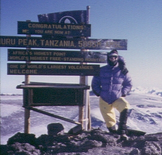
|
By Stella Point, our group was mixed with others and we had no idea how many had turned back. At the summit, we thought about 12 people had made it. As we headed down some time later, we were surprised to pass several of our group still ascending (in all, 20 out of 30 made it all the way to Uhuru). At least one of the late arrivals was unresponsive, not looking at me or acknowledging my greeting, but no one keeled over and died. Does that mean we were safe, or that we got away with it? Ray turned back at Stella after his vision started to go - later examination suggests it was early cerebral edema, with the vision problems caused by a burst blood vessel in the eye. His vision returned in a day or two, but it was frightening to know that he could not descend on his own even after a rest in Barafu.
The descent back to camp went very quickly, aided by guides who knew where to charge down sandy chutes and where to cross rock ribs. Generally the return route stayed north of the ascent route between Stella and Barafu. We relaxed in camp until the last people returned (several hours later), then headed down the Mweka Trail. From sand to rocks to mud, it was a damn long way down to our final camp (waypoint D6CAMP, which may or may not be the Mweka Hut at about 10000'). We passed one hut along the way, where people offered us water, but continued to the lower camp where you can buy beer. It rained within minutes of the last person reaching camp, but no one cared.
I was also disappointed that summit day involved 4500' of climbing followed by 9000' of descent! Yes, we dropped from 19k down to 10k the same day we summited. Several people were limping by the time they reached camp, and that was unnecessary since we had passed several good campsites (at least one of which had water) several hours before our final camp. The exit trailhead was at about 6000', so it seems like staying at the higher camp on the way out would better divide the pain/effort between the two last days.
A note on tipping: Members of our group gave food and boots to the porters, both before the trip and during the climb itself. In several cases, we later saw the guides eating the food and wearing the boots. It was obvious that the "pecking order" allowed those higher in the tree to demand items be turned over from those lower on the tree. Gifts my wife and I gave to our guides were instantly hidden from view, as if receiving something was going to cause problems later. If I'm ever there again, I plan to tip more frequently, in smaller amounts using local currency, IN SECRET, instead of handing over used clothing. I'm not sure how much of our charity loot stayed with the people we intended it to help.
Members of our group were: Ursela Austin, Alfred* and Edith* Bogenhuber, Rebecca and Steve* Eckert, Bob* Evans, Jeff Fisher, Tim* Kutscha, Hailen* Mak, Francoise* Mertz, Ray+ Morris, Stuart* Nelson, Caroline* Pease, Ron* Perkins, Ted* Raczek, Susanne Remien, Enrique* Rodriguez, Bonnie* Ruesch, Charles* Schafer, Betty Sills, Dixie and Warren* Storkman (trip organizers), Peter Swentzel, Joan* Szarfinski, Richard* Vassar, Leanne and Bill* Weinstein, Peter* Wijeratne, Dieter+ Wilk, Marilyn* Yee. 20 out of 30 people got to the true summit (Uhuru Peak, marked with "*" above), and another 2 people got to Stella Point (the crater rim, marked with "+" above).
Other reports written by members of our group are on the web: Tim Kutscha provided lots of info, not just a trip report, and Rebecca Wolf wrote a non-climber's review of a climbing trip. For a comparitive experience on a 5-day trip, read John Flinn's extremely well written report Chunder on the Equator.
The color topo map I bought from Chessler Books is about as good as it gets, but there is another topo map available in Tanzania that purports to show elevation profiles and distances on the various routes. NEITHER MAP MATCHES THE ACTUAL TRAILS, at least on the Machame Route, where we dropped into 1000' valleys that are not shown on the maps.
The elevation gain per day is what I observed, and I know it doesn't match the trail maps. I corrected the readings for a linear (scale factor) error of 800' out of 19000', well within the 10% variation of air column density that can occur due to seasonal changes. In English, that means my Avocet altimeter was off by only 4% at the summit, having last been calibrated at sea level, so I adjusted all my readings upward by 4% rather than pretending to calibrate it at camps whose locations weren't really well known.
day 1, Jan 17: trailhead to Machame Camp,      4000' gain, 10200' camp
day 2, Jan 18: Machame Camp to Shira Camp,     2800' gain, 12800' camp
day 3, Jan 19: Shira to 15k, down to Barranco, 2500' gain, 13200' camp
day 4, Jan 20: Barranco to Karanga to Barafu   3600' gain, 15300' camp
day 5, Jan 21: layover, some dayhiked a few hours
day 6, Jan 22: Barafu to Uhuru, via Stella Pt  4500' gain, 19300' peak
day 6 GOES ON: Uhuru via Barafu to Mweka Camp, 9000' down, 10000' camp
day 7, Jan 23: Mweka Camp down to trailhead,   4000' down, to trucks
TOTAL: over 17k of gain, but much more comfortable than standard 5-day trip
![]() Download the Waypoint+ data below as a GPX file for your GPS.
Download the Waypoint+ data below as a GPX file for your GPS.
Datum,North America 1983,GRS 80,0,-1.6E-7,0,0,0
WP,D,MARHOT , -3.295737589, 37.5243991613,12/31/1989,00:00:00,MARANGU HOTEL
WP,D,KIBHOT , -3.286934579, 37.5177097321,12/31/1989,00:00:00,KIBO HOTEL
WP,D,MACHTH , -3.173208917, 37.2386956215,12/31/1989,00:00:00,MACHAME TRAILHEAD
WP,D,D1WPT1 , -3.128931010, 37.2483944893,12/31/1989,00:00:00,HALFWAY DAY 1
WP,D,MACHAM , -3.096175874, 37.2649383545,12/31/1989,00:00:00,MACHAME HUT CAMP
WP,D,D2WPT1 , -3.086251700, 37.2761070728,12/31/1989,00:00:00,MIDMORNING DAY 2
WP,D,D2WPT2 , -3.070190633, 37.2806668282,12/31/1989,00:00:00,ONTO RIDGE DAY 2
WP,D,SHIRAH , -3.064971054, 37.2761231661,12/31/1989,00:00:00,SHIRA HUT CAMP
WP,D,D3WPT1 , -3.067336762, 37.2955477238,12/31/1989,00:00:00,EARLY TRAIL DAY 3
WP,D,D3WPT2 , -3.068522299, 37.3177081347,12/31/1989,00:00:00,1ST SADDLE DAY 3
WP,D,D3WPT3 , -3.081756318, 37.3229330778,12/31/1989,00:00:00,2ND SADDLE DAY 3
WP,D,BARNCO , -3.095204914, 37.3305183649,12/31/1989,00:00:00,BARRANCO HUT CAMP
WP,D,D4WPT1 , -3.098960007, 37.3366552591,12/31/1989,00:00:00,TOP OF WALL DAY 4
WP,D,D4WPT2 , -3.107999051, 37.3467832804,12/31/1989,00:00:00,2ND RIDGE DAY 4
WP,D,KARANG , -3.111335719, 37.3530542850,12/31/1989,00:00:00,KARANGA VLY LUNCH
WP,D,D4WPT4 , -3.121265257, 37.3680639267,12/31/1989,00:00:00,CAN SEE MWEKA TRAIL
WP,D,D4WPT5 , -3.113637054, 37.3748284578,12/31/1989,00:00:00,POSSIBLE CAMP
WP,D,BARAFU , -3.101202333, 37.3787122965,12/31/1989,00:00:00,BARAFU HUT CAMP
WP,D,D6WPT1 , -3.092249120, 37.3767596483,12/31/1989,00:00:00,PEAK ROUTE DAY 6
WP,D,D6WPT2 , -3.089588368, 37.3734337091,12/31/1989,00:00:00,PEAK ROUTE DAY 6
WP,D,D6WPT3 , -3.088880265, 37.3718887568,12/31/1989,00:00:00,PEAK ROUTE DAY 6
WP,D,D6WPT4 , -3.087040270, 37.3707836866,12/31/1989,00:00:00,PEAK ROUTE DAY 6
WP,D,D6WPT5 , -3.084406341, 37.3680371046,12/31/1989,00:00:00,PEAK ROUTE DAY 6
WP,D,D6WPT6 , -3.078864897, 37.3635256290,12/31/1989,00:00:00,PEAK ROUTE DAY 6
WP,D,STELLA , -3.078178251, 37.3624473810,12/31/1989,00:00:00,CRATER RIM
WP,D,UHURUP , -3.076611841, 37.3539984226,12/31/1989,00:00:00,KIBO SUMMIT
WP,D,D6WPT7 , -3.118427480, 37.3732191324,12/31/1989,00:00:00,1ST MWEKA JCT
WP,D,D6WPT8 , -3.121313537, 37.3718565702,12/31/1989,00:00:00,2ND MWEKA JCT
WP,D,D6WPT9 , -3.137471164, 37.3721569777,12/31/1989,00:00:00,UPPER MWEKA HUT
WP,D,D6CAMP , -3.155940855, 37.3675864935,12/31/1989,00:00:00,LOWER MWEKA HUT
WP,D,MWEKAT , -3.219713057, 37.3413223028,12/31/1989,00:00:00,MWEKA TRAILHEAD