Sierra Peaks - Region 15
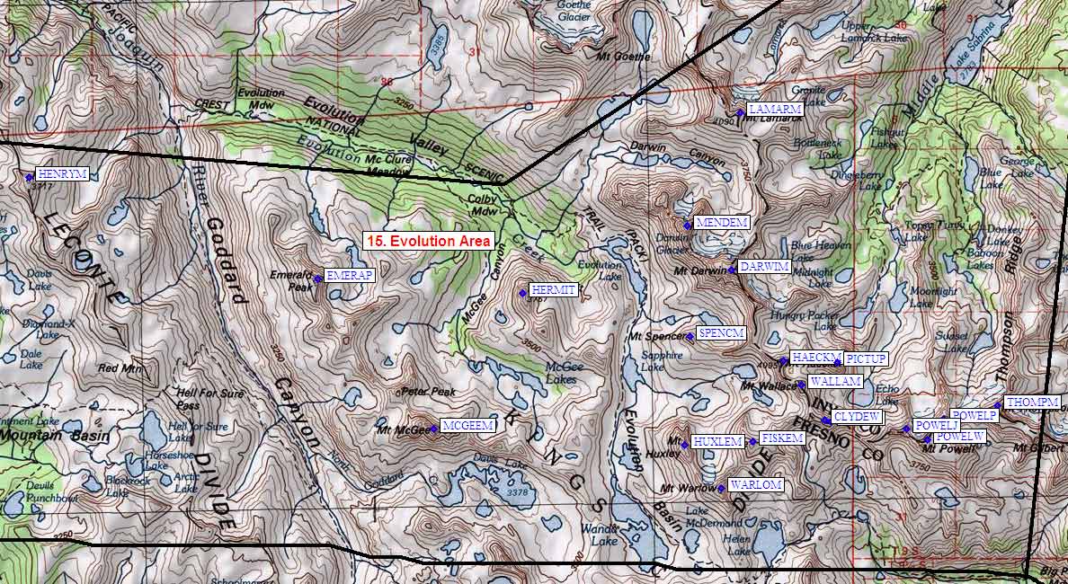
Evolution Area
Generated on 10 Aug 2024 - see revision history - please send updates to the webmaster
|
Evolution Area sorted numerically on Num column | ||||||||||||||
| Click on the peak name for similarly named peaks in a statewide peaks database. | ||||||||||||||
| click on these headings to sort by that column | click on these headings for more info | |||||||||||||
| Num | Peak Name (more links) | Waypoint | Elev | SPS | Class | Pics and Reports | UTM hint (map) | 7.5' USGS topo quad | Register | |||||
| 15.1 | Thompson Mt | THOMPM | 13494 | 2 | 1 pic of ThompsonMt 11 reports on thompson | 568117 | Mt Thompson | |||||||
| 15.2 | Powell aka Pt Powell | POWELP | 13360+ | 2s3 | 1 pic of PowellakaPtPowell 10 reports on powell | 557115 | Mt Thompson | |||||||
| 15.3 | Wallace Mt | WALLAM | 13377 | 2s3 | 4 reports on wallace | 529122 | Mt Darwin | |||||||
| 15.4 | Haeckel Mt | HAECKM | 13418 | 3 | 6 reports on haeckel | 526127 | Mt Darwin | |||||||
| 15.5 | Fiske Mt | FISKEM | 13503 | 2 | 3 reports on fiske | 520111 | Mt Darwin | |||||||
| 15.6 | Huxley Mt | HUXLEM | 13086 | 3 | 4 reports on huxley | 506111 | Mt Darwin | |||||||
| 15.7 | Darwin Mt | DARWIM | 13831 | E | 3s4 | 1 pic of DarwinMt 9 reports on darwin | 516145 | Mt Darwin | ||||||
| 15.8 | Mendel Mt | MENDEM | 13710 | 3 | 1 pic of MendelMt 8 reports on mendel | 507154 | Mt Darwin | |||||||
| 15.9 | Lamarck Mt | LAMARM | 13417 | 1 | 2 reports on lamarck | 518176 | Mt Darwin | |||||||
| 15.10 | Hermit The | HERMIT | 12328 | M | 2s5 | 1 pic of HermitThe 2 reports on hermit | 475141 | Mt Darwin | ||||||
| 15.11 | McGee Mt | MCGEEM | 12944 | 3 | 3 reports on mcgee | 457115 | Mt Darwin | |||||||
| 15.12 | Emerald Peak | EMERAP | 12546 | 2 | 2 reports on emerald | 435145 | Mt Henry | |||||||
| 15.13 | Henry Mt | HENRYM | 12196 | 2 | 6 reports on henry | 379166 | Mt Henry | |||||||
| 15.14 | Spencer Mt | SPENCM | 12400 | X | 2 | 3 reports on spencer | 508132 | Mt Darwin | ||||||
| 15.15 | Warlow Mt | WARLOM | 13508 | X | 2 | 1 report on warlow | 513102 | Mt Darwin | need | |||||
| 15.16 | Powell aka Pt Wesley | POWELW | 13356 | X | 2 | 1 pic of PowellakaPtWesley 10 reports on powell | 554111 | Mt Darwin | ||||||
| 15.17 | Powell Mt aka Pt John | POWELJ | 13364 | X | 3 | 2 pics of PowellMtakaPtJohn 10 reports on powell | 550113 | Mt Darwin | ||||||
| 15.18 | Clyde Spires East | CLYDEE | 13200 | X | 3 | 5 reports on clyde | 535115 | Mt Darwin | need | |||||
| 15.19 | Clyde Spires West | CLYDEW | 13200 | X | 3s4 | 5 reports on clyde | 534115 | Mt Darwin | need | |||||
| 15.20 | Picture Peak | PICTUP | 13120 | X | 3 | 4 reports on picture | 536127 | Mt Darwin | ||||||
NOTE: M = Mountaineers Peak, E = Emblem Peak, X = not on SPS List (in 'SPS' column)
      ^ = metric contours and elevations on 7.5' maps (in 7.5' map columns)
      Name Mt  => 'Mt' is before peak 'Name' (ex: Rose Mt is Mount Rose, but sorted on 'Rose')
      Name Mtn => 'Mtn' is after peak 'Name' as listed (ex: Muah Mtn is Muah Mountain)
The "UTM Hint" in the table above approximates the peak location to the nearest 100 meters.
Click here for info on Universal Transverse Mercator coordinates.
Useful Links: