Owens Peak
Revised 15 Jul 2013 - please send updates to the webmaster
| From 'ratsalad' in 2013: As of 7/14, there were SE152 or SE164 plastic blm wilderness signs the entire way. Maybe only a year old. Mid summer and 4x4 not required at all, but High clearance a good idea. Along the trail after 20 minutes or so, you will start to see stacked rocks helping guide your path, almost the entire way to the top of Owens Peak. |
The trailhead for Owens Peak is best reached by four wheel drive vehicles with high clearance. You may need to shuttle from the end of the improved road to the trailhead, or else you may need to hike additional miles. The exact route of the road has changed over the years, the line on the map below was logged by GPS in 2006. It took about half an hour to drive from Hwy 14 to the Owens Peak trailhead in a high clearance vehicle (4WD not needed).
Starting on Hwy 14 where Hwy 178 turns east to Ridgecrest (becoming InyoKern Avenue), go just over two miles north on Hwy 14, to the Indian Wells Lodge. The parking lot of the lodge is a good carpool rendezvous; the turnoff to the trailhead can be missed since it has no sign visible at highway speeds. The lodge is near the Homestead Cafe and the well marked Indian Wells Brewing Company. Don't count on breakfast anywhere between here and Mojave.
From the lodge, go 0.2 miles north on Hwy 14 to the first dirt road on the left - this is the Indian Wells Canyon Road junction with Hwy 14 (waypoint IWCJ14), which is 1.6 miles south of Hwy 395. The turn isn't well marked but there is a small brown vertical stake that says Indian Wells and a cattle guard. If you're headed north, you'll either have to drive across the median to reach the dirt road, or go about three fourths of a mile north to an official turnaround. After you start up the dirt road, you'll see a small red fiberglass sign identifying the road as SE152.
Go 2.7 miles up the main dirt road (SE152, Indian Wells Canyon Road), to "Powers Well" and the junction with SE164 (waypoint POWERJ). Just before the junction, there is an old square rock-walled cistern near a small cofferdam on the left (waypoint POWERP). It's another great place to meet because it has a parking lot and a sign of some sort. Turn right at waypoint POWERJ and go up the west side of an old gravel pit at about 3500' elevation. After Powers Well, continue northwest in the main drainage, staying to the left of the channel that often has flowing water. The trailhead for Five Fingers is at waypoint FINGRT, a circular parking area downhill from the road and just under half a mile north of the turn at POWERJ. This is as far as passenger cars may want to go, depending on the road conditions during any given year.
Stay left but stay in the main drainage and stay on a northwest heading. Ignore the junctions around 3800' that drop toward the creek (near waypoint FINGRJ). The road you want climbs over a 4300' shoulder on the left of the drainage, about 5 miles from Hwy 14. From this shoulder on you are well south of the main Indian Canyon drainage. Just beyond the shoulder, at 4300', you will come to another fiberglass sign that says "Owens Peak" at waypoint OPJCT1. THE ROAD HAS CHANGED HERE! There are several junctions in the area, make sure you watch carefully for this sign! You must turn right here and drop down across a minor drainage. In 2006 a passenger car could have reached OPJCT1 without much difficulty, but would not have gotten much further.
At 4600' (waypoint OPJCT2) you cross another minor drainage and continue on what the topo map shows as a jeep trail instead of a dirt road. Here there is a fiberglass sign saying only "OP" at the bottom. Once again you turn right. Once again the road gets a bit worse.
Go up SE164 to a junction near Morris Canyon (waypoint MORISJ) where you are suddenly seeing real trees. Park here for Morris Peak, walking straight up the ridge to the PCT and taking the trail south to Morris. For Owens Peak, turn right and continue half a mile north to the boundary of the Wilderness (waypoint OPPARK at 5400', 7.5 miles from the pavement) where you can park and camp. At the trailhead there is a right fork to a great camping area, waypoint OPCAMP, and you should also see another SE164 fiberglass sign near here.
NOTE: Various descriptions have various mileages, and some have a list of turns
with no explanation of what the terrain looks like. YOUR MILEAGE MAY VARY!
Anyone who finds these GPS coordinates or the description above to be in error
is encouraged to contact us and we'll eagerly correct it!
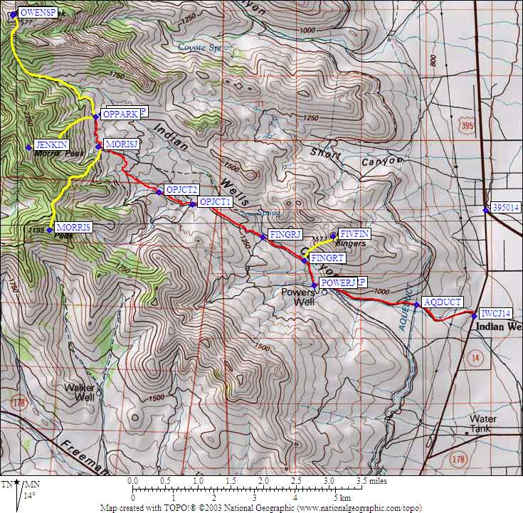
Overall map:
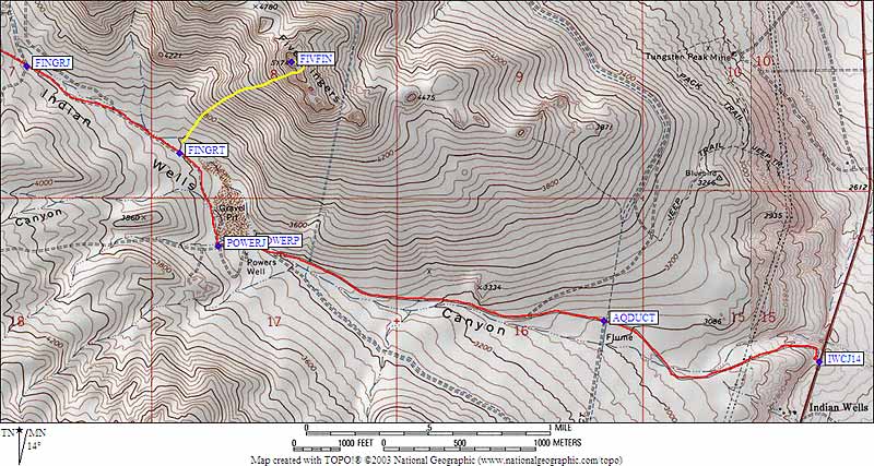
Five Fingers map:
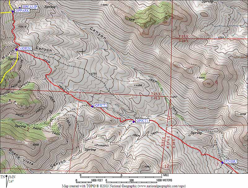
Owens Peak map: Useful Links:
Maps of Owens/Jenkins/Morris/FiveFingers driving directions: