Sugar Pine Point and Rubicon Staging Area
Revised Dec 2007 - please send updates to the webmaster
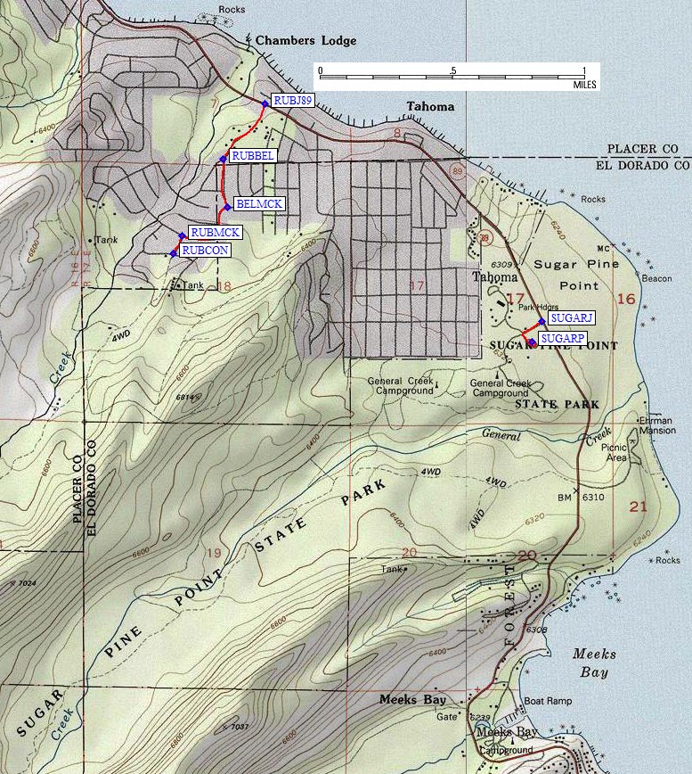
Sugar Pine Point State Park (south of the Homewood Ski Area on the west shore of Lake Tahoe) has a year-round paid parking lot for backcountry use, some groomed cross-country ski trails, and appears to be the only legal parking for winter use of the backcountry in this area. Leave Hwy 89 at waypoint SUGARJ, pay at the kiosk, then turn left (south) and follow the signs to the plowed day use parking lot at waypoint SUGARP. Trails wander around the flatlands, and you can make your way up General Creek for true backcountry access (perhaps to the Ludlow Hut, which I've been told is accessible in summer via the Rubicon Trail, but for which I don't have a precise location).
WARNING: The Rubicon Trail directions given below are NOT for winter use. If you try to park at the start of the staging area road, you may be towed. The road is used as a place for snowplows to dump snow from residential streets, and those streets do not allow winter parking.
To reach the Rubicon Trail staging area near Sugar Pine Point, you can follow fairly clear signs mentioning Rubicon and Miller Lake: Leave Hwy 89 at the Old Rubicon Road (waypoint RUBJ89). Bear left at the fork onto Bellvue Ave (waypoint RUBBEL). Turn right on McKinney Rd (waypoint BELMCK) and follow it south then west as it becomes Springs Court... then as it continues straight and becomes Cascade Drive, turn left on McKinney Rubicon Springs Rd (waypoint RUBMCK) and follow it to the large sign at waypoint RUBCON. This sign says NOT to park here any time! This is where you leave the paved residential streets and take a dirt road 1.5 miles to the staging area. (My waypoint RUBCON is the sign, NOT the staging area, because I haven't been here in summer.) In winter, the dirt road becomes a snowbank pushed far back from the pavement, and it LOOKS like a good place to park. Locals told me that cars get towed here all the time because the snowplows use it for excess snow storage.
Useful Links: