Dry Mtn and Tin Mtn
Revised May 2008 - please send updates to the webmaster
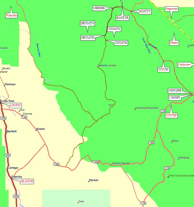
Take your favorite route to Death Valley, specifically Stovepipe Wells (waypoint STOVEP), then take Hwy 190 (which is also Hwy 178) northeast to the junction with the North Hwy (waypoint 178NHW, where 178/190 turns south to Badwater). Turn left (northwest) on North Hwy, going past the turnoff to Daylight Pass (waypoint NHWDPR). Continue about 30 miles north to waypoint SCOTTY, where North Hwy turns northeast to Scotty's Castle and and Scotty's Junction, and turn left (west) on Death Valley Road toward Ubehebe Crater and The Racetrack.
The pavement ends near waypoint RACETR, where you follow the signs to The Racetrack (not a speedway, a dry lake with boulders sliding around in it). Go straight instead of following Death Valley Road - and if you're tempted to take Death Valley Road to Big Pine, keep in mind that it's not all good road. I made it fine in a little Honda CRX a few years ago, but passed a VW bus that had two flat tires.
Follow a good dirt road to Ubehebe Crater (waypoint UBEHEB), a swell view down into a big hole. Stay straight on the road to The Racetrack as it bends south and becomes much rougher. Shortly after Ubehebe is a sign that says "No Camping next 2 miles". The rangers told me there were sharp rocks that slashed everyone's tires, and you needed high clearance 4WD. Nope. It's just washboards and some medium rocks. We saw a minivan that was doing just fine with less clearance than a passenger car.
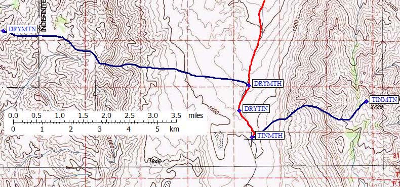
My GPS track log says it's 9.1 miles from the Ubehebe Crater turnoff to the pullout (aka 'Trailhead', waypoint DRYMTH) for Dry Mtn. The DPS Guide says 9.5 miles, which could be wheel slip on washboards, so either use the waypoint or watch your altimeter for 4500 feet. The pullout is on the west side of the road, and big enough for 4 or 5 vehicles. We camped here, since we were well outside the 2 mile no-camping zone around Ubehebe, finding some nice tent sites on firm gravel.
There is a pullout between the Dry and Tin starting point, which I've marked as DRYTIN on the map below, but driving on up the road to 4900 feet saves you several hundred feet of climbing. The Tin Mtn pullout/trailhead (waypoint TINMTH) is 10.5 miles from Ubehebe according to my GPS track log. This pullout is a bit smaller than the Dry Mtn pullout and doesn't seem to have good/responsible campsites. The road which continues on through Teakettle Junction and down to Hwy 190 may look the same on the map, but unless you're a hard-core 4WD enthusiast you should only consider approaching these trailheads from the north.
Useful Links: