Map exported from TOPO! software, used with permission.
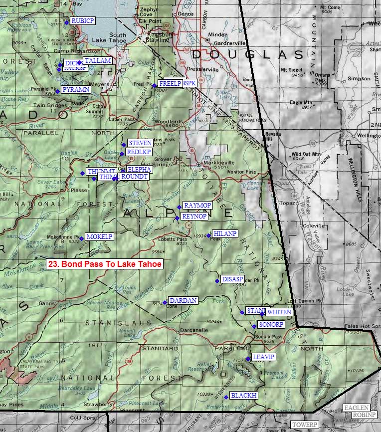
| Bond Pass To Lake Tahoe sorted numerically on Num column | ||||||||||||||
| click on these headings to sort by that column | click on these headings for more info | |||||||||||||
| Num | Peak Name (more links) | Waypoint | Elev | SPS | Class | Pics and Reports | UTM hint (map) | 7.5' Map | Register | |||||
| 23.1 | Black Hawk Mtn | BLACKH | 10348 | 2 | 1 pic of BlackHawkMtn 4 reports on hawk | 629320 | Emigrant Lake | |||||||
| 23.2 | Leavitt Peak | LEAVIP | 11569 | 1 | 3 pics of LeavittPeak 4 reports on leavitt | 682407 | Sonora Pass | need | ||||||
| 23.3 | Stanislaus Peak | STANIP | 11233 | 1 | 1 pic of StanislausPeak 2 reports on stanislaus | 671516 | Disaster Peak | need | ||||||
| 23.4 | Disaster Peak | DISASP | 10047 | 2 | 4 reports on disaster | 615589 | Disaster Peak | |||||||
| 23.5 | Highland Peak | HILANP | 10935 | 2 | 1 pic of HighlandPeak 3 reports on highland | 599695 | Ebbets Pass | need | ||||||
| 23.6 | Mokelumne Peak | MOKELP | 9334 | 2 | 1 pic of MokelumnePeak 5 reports on mokelumne | 533693 | Mokelumne Peak | need | ||||||
| 23.7 | Round Top | ROUNDT | 10381 | 3 | 3 pics of RoundTop 14 reports on round | 390835 | Carson Pass | need | ||||||
| 23.8 | Freel Peak | FREELP | 10881 | 1 | 1 pic of FreelPeak 5 reports on freel | 484048 | Freel Peak | |||||||
| 23.9 | Pyramid Peak N | PYRAMN | 9983 | 2 | 1 pic of PyramidPeakN 15 reports on pyramid | 468032 | Pyramid Peak | |||||||
| 23.10 | Dicks Peak | DICKSP | 9974 | 2 | 1 pic of DicksPeak 5 reports on dicks | 472094 | Rockbound Valley | |||||||
| 23.11 | Tallac Mt | TALLAM | 9735 | 1 | 1 pic of TallacMt 9 reports on tallac | 517101 | Emerald Bay | |||||||
| 23.12 | Jacks Peak | JACKSP | 9856 | X | 2 | 1 pic of JacksPeak 5 reports on jacks | 469083 | Rockbound Valley | ||||||
| 23.13 | Rubicon Peak | RUBICP | 9183 | X | 2s3 | 1 pic of RubiconPeak 2 reports on rubicon | 484192 | Rockbound Valley | ||||||
| 23.14 | Jobs Sister | JOBSIS | 10823 | X | 2 | 2 reports on jobssister | 498052 | Freel Peak | ||||||
| 23.15 | Jobs Peak | JOBSPK | 10633 | X | 2 | 1 report on jobs | 518047 | Freel Peak | ||||||
| 23.16 | Stevens Peak | STEVEN | 10059 | X | 2 | 2 reports on stevens | 409912 | Carson Pass | ||||||
| 23.17 | Red Lake Peak | REDLKP | 10063 | X | 2s3 | 13 reports on red | 404892 | Carson Pass | ||||||
| 23.18 | Elephants Back | ELEPHA | 9585 | X | 2 | 1 report on elephant | 406851 | Carson Pass | ||||||
| 23.19 | Thunder Mtn | THUNMT | 9408 | X | 2 | 6 reports on thunder | 532844 | Caples Lake | ||||||
| 23.20 | Thimble Peak | THIMBL | 9805 | X | 2s5 | 2 reports on thimble | 559832 | Caples Lake | ||||||
| 23.21 | Sisters E | SISTRE | 10153 | X | 2 | 3 reports on sister | 604834 | Caples Lake | ||||||
| 23.22 | Raymond Peak | RAYMOP | 10014 | X | 2 | 1 report on raymond | 534764 | Ebbets Pass | ||||||
| 23.23 | Reynolds Peak | REYNOP | 9679 | X | 0 | 528739 | Ebbets Pass | |||||||
| 23.24 | Dardanelles Cone | DARDAN | 9524 | X | 0 | 1 report on dardanelles | 493544 | Dardanelles Cone | ||||||
| 23.25 | Sonora Peak | SONORP | 11462 | X | 2 | 1 pic of SonoraPeak 2 reports on sonora | 698482 | Sonora Pass | ||||||
NOTE: M = Mountaineers Peak, E = Emblem Peak, X = not on SPS List (in 'SPS' column)
^ = metric contours and elevations on 7.5' maps (in 7.5' map columns)
Name Mt => 'Mt' should be before peak 'Name' (ex: Rose Mt is Mount Rose, but sorted on 'Rose')
Name Mtn => 'Mtn' is after peak 'Name' as listed (ex: Muah Mtn is Muah Mountain)
Maps listed here are USGS 7.5 minute topo quads
Below are GPS waypoints, in Waypoint+ text format, suitable for downloading to a GPS or importing/viewing in TOPO! software. The comment field contains the exact peak name, as in the various lists of peaks, but may be truncated by your GPS. The waypoint names are all abbreviated to 6 characters. Note that peaks marked by 'X' in the table above are not on the SPS List.
The first set of data below has decimal degrees, with latitude and longitude after the 3rd and 4th comma. The second set of data shows full UTM zone, easting, and northing after the 3rd, 4th, and 5th commas. The "UTM Hint" in the table above represents the peak location to the nearest 100 meters, use the data below for more precision.
NAD83 datum, Latitude/Longitude in decimal degrees (UTM below).
Datum,North America 1983,GRS 80,0,-1.6E-7,0,0,0
RouteName,23,BONDPLKTAHOE
RoutePoint,D,BLACKH,38.2061677,-119.7089537,10/08/2008,00:02:52,BLACK HAWK MTN
RoutePoint,D,LEAVIP,38.2861468,-119.6511722,10/08/2008,00:02:52,LEAVITT PEAK
RoutePoint,D,STANIP,38.3840110,-119.6670103,10/08/2008,00:02:52,STANISLAUS PEAK
RoutePoint,D,DISASP,38.4486084,-119.7337596,10/08/2008,00:02:52,DISASTER PEAK
RoutePoint,D,HILANP,38.5436825,-119.7553895,10/08/2008,00:02:52,HIGHLAND PEAK
RoutePoint,D,MOKELP,38.5380324,-120.0943936,10/08/2008,00:02:52,MOKELUMNE PEAK
RoutePoint,D,ROUNDT,38.6635924,-120.0009716,10/08/2008,00:02:52,ROUND TOP
RoutePoint,D,FREELP,38.8575074,-119.9000302,10/08/2008,00:02:52,FREEL PEAK
RoutePoint,D,PYRAMN,38.8450311,-120.1577224,10/08/2008,00:02:52,PYRAMID PEAK N
RoutePoint,D,DICKSP,38.9003812,-120.1509345,10/08/2008,00:02:52,DICKS PEAK
RoutePoint,D,TALLAM,38.9059088,-120.0989897,10/08/2008,00:02:52,TALLAC MT
RoutePoint,D,JACKSP,38.8903400,-120.1540200,10/08/2008,00:02:52,JACKS PEAK
RoutePoint,D,RUBICP,38.9885200,-120.1332400,10/08/2008,00:02:52,RUBICON PEAK
RoutePoint,D,JOBSIS,38.8622800,-119.8844600,10/08/2008,00:02:52,JOBS SISTER
RoutePoint,D,JOBSPK,38.8581700,-119.8613700,10/08/2008,00:02:52,JOBS PEAK
RoutePoint,D,STEVEN,38.7337200,-119.9817300,10/08/2008,00:02:52,STEVENS PEAK
RoutePoint,D,REDLKP,38.7147900,-119.9869600,10/08/2008,00:02:52,RED LAKE PEAK
RoutePoint,D,ELEPHA,38.6785200,-119.9832300,10/08/2008,00:02:52,ELEPHANTS BACK
RoutePoint,D,THUNMT,38.6742100,-120.0908400,10/08/2008,00:02:52,THUNDER MTN
RoutePoint,D,THIMBL,38.6624300,-120.0605400,10/08/2008,00:02:52,THIMBLE PEAK
RoutePoint,D,SISTRE,38.6624500,-120.0079800,10/08/2008,00:02:52,SISTERS E
RoutePoint,D,RAYMOP,38.6037289,-119.8332696,10/08/2008,00:02:52,RAYMOND PEAK
RoutePoint,D,REYNOP,38.5808135,-119.8386358,10/08/2008,00:02:52,REYNOLDS PEAK
RoutePoint,D,DARDAN,38.4046400,-119.8724000,10/08/2008,00:02:52,DARDANELLES CONE
RoutePoint,D,SONORP,38.3539111,-119.6354133,10/08/2008,00:02:52,SONORA PEAK
NAD27 datum, UTM Zone/East/North in decimal meters (degrees above).
Datum,North America 1927 mean,Clarke 1866 ,-69.4,-0.37264639,-8,160,176
RouteName,23,BONDPLKTAHOE
RoutePoint,UTM,BLACKH,11,262890.0,4231960.0,10/08/2008,00:02:52,BLACK HAWK MTN
RoutePoint,UTM,LEAVIP,11,268204.4,4240689.9,10/08/2008,00:02:52,LEAVITT PEAK
RoutePoint,UTM,STANIP,11,267132.6,4251591.2,10/08/2008,00:02:52,STANISLAUS PEAK
RoutePoint,UTM,DISASP,11,261514.0,4258931.5,10/08/2008,00:02:52,DISASTER PEAK
RoutePoint,UTM,HILANP,11,259942.1,4269539.9,10/08/2008,00:02:52,HIGHLAND PEAK
RoutePoint,UTM,MOKELP,10,753348.8,4269321.9,10/08/2008,00:02:52,MOKELUMNE PEAK
RoutePoint,UTM,ROUNDT,11,238970.0,4283520.1,10/08/2008,00:02:52,ROUND TOP
RoutePoint,UTM,FREELP,11,248436.7,4304761.1,10/08/2008,00:02:52,FREEL PEAK
RoutePoint,UTM,PYRAMN,10,746769.9,4303224.3,10/08/2008,00:02:52,PYRAMID PEAK N
RoutePoint,UTM,DICKSP,10,747167.1,4309386.4,10/08/2008,00:02:52,DICKS PEAK
RoutePoint,UTM,TALLAM,10,751653.0,4310142.0,10/08/2008,00:02:52,TALLAC MT
RoutePoint,UTM,JACKSP,10,746934.0,4308263.0,10/08/2008,00:02:52,JACKS PEAK
RoutePoint,UTM,RUBICP,10,748394.0,4319218.0,10/08/2008,00:02:52,RUBICON PEAK
RoutePoint,UTM,JOBSIS,10,249805.0,4305248.0,10/08/2008,00:02:52,JOBS SISTER
RoutePoint,UTM,JOBSPK,10,251794.0,4304729.0,10/08/2008,00:02:52,JOBS PEAK
RoutePoint,UTM,STEVEN,10,240898.0,4291249.0,10/08/2008,00:02:52,STEVENS PEAK
RoutePoint,UTM,REDLKP,10,240375.0,4289163.0,10/08/2008,00:02:52,RED LAKE PEAK
RoutePoint,UTM,ELEPHA,11,240568.0,4285127.0,10/08/2008,00:02:52,ELEPHANTS BACK
RoutePoint,UTM,THUNMT,11,753179.0,4284447.0,10/08/2008,00:02:52,THUNDER MTN
RoutePoint,UTM,THIMBL,11,755857.0,4283223.0,10/08/2008,00:02:52,THIMBLE PEAK
RoutePoint,UTM,SISTRE,11,760431.0,4283374.0,10/08/2008,00:02:52,SISTERS E
RoutePoint,UTM,RAYMOP,11,253359.0,4276411.1,10/08/2008,00:02:52,RAYMOND PEAK
RoutePoint,UTM,REYNOP,11,252813.0,4273882.1,10/08/2008,00:02:52,REYNOLDS PEAK
RoutePoint,UTM,DARDAN,11,249261.0,4254420.0,10/08/2008,00:02:52,DARDANELLES CONE
RoutePoint,UTM,SONORP,11,269797.4,4248171.2,10/08/2008,00:02:52,SONORA PEAK