Armstrong Canyon and Sawmill Pass
Revised 26 Aug 2014 - please send updates to the webmaster
Sawmill Pass provides access to Mt Perkins, Colloseum Mtn, and Mt Baxter. Armstrong Canyon is often used to climb Mt Perkins, and is one of the few places where a 4WD can be put to good use reaching an unmaintained trailhead on the east side. This is an infrequently visited area on the eastern fringe of Kings Canyon National Park. The Division Creek Powerhouse is a great landmark that will help you find each other, and there is lots of parking there for those who don't want to risk taking passenger cars further.
The map for GPS route SAWMILL EASY 2WD shows roads and waypoints from 395 to the powerhouse:
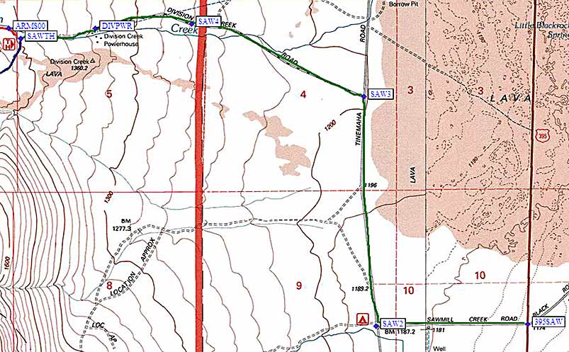
Start by getting yourself to US-395 between Independence and Big Pine on the east side of the Sierra Nevada. Turn west on Black Rock Springs Road (not Division Creek Road), which is marked by road name signs on each side of the highway and a large yellow 4-way intersection sign (waypoint 395SAW). This intersection is 18 miles south of Big Pine, 2 miles south of a rest stop, and 8 miles north of Independence.
Follow Black Rock Springs Road (the green line on the map above, which is called Sawmill Creek Road on some maps) from US-395 (waypoint 395SAW) due west to a 'T' intersection with Tinemaha Road (waypoint SAW2). Turn right (north) at the 'T' and then turn left (west again) at Division Creek Road (waypoint SAW3) where a brown sign points you to the 'Sawmill Pass Trail'. Stay on this road as it goes west-northwest through waypoint SAW4 (not a junction, just west of a cattle guard) and then west to the powerhouse at waypoint DIVPWR (where the pavement ends). Unless you're meeting people at the powerhouse, continue to the Sawmill Pass trailhead at waypoint SAWTH. (On the map below, the trail to Sawmill Pass is the blue line that goes southwest from SAWTH, and the road to Armstrong is the red line making a right turn to the northwest at SAWTH.)
| Richard Carey reports as of August 2013: Turning on the Division Creek Road there was a temporary sign saying Road Closed Ahead. Driving past the power station it looked a mess with a lot of work going on. I later realized it was from storm damage. Up ahead water trucks were dumping water on the newly graded road. It didn't look good and near the end I talked to a backhoe driver who was winding down for the day. He said the road to Scotty's Spring was wiped out by a recent storm. He suggested I drive up to the end and see for myself. Yes, it was a mess. A huge torrent must have come down Division Creek. This is just before the road makes a turn north to go up the slopes. He said they would fix it to the spring and I asked about further up, but I am not sure he understood my question so I don't know if they are going to fix the upper 4WD section and it may be in bad shape with rocks on the road. |
| Tom reports as of August 2014: I tried going up Armstrong Canyon yesterday and thought I'd give you an update on conditions. I had been up there 4 years ago with an old Jeep Cherokee and didn't remember any problems. The road to Scotty's Spring has been restored. A lot of material has washed down over the last several years so the road is slumping with many little fans of sand on the first switchback. The pumice area was no problem for my AWD Honda Element (badged as 4WD but not really) and then I started hitting soft sand. Got past one section after a couple of tries but got stuck just before the end of the second switchback where I got hung up on a good sized rock. Once I stopped moving, the sand got me. Normal 4WDs with good clearance would have no problem on this road but I'm not sure about other AWDs although mine has one of the lowest clearances in the AWD family. |
The map for GPS route SAWMILL HARD 4WD
shows details of the two trailheads above the powerhouse:
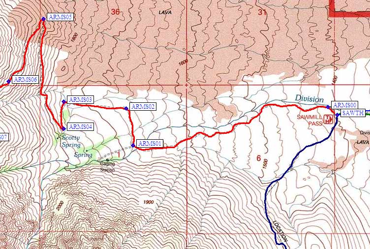
If you're headed for Armstrong Canyon, continue northwest past the Sawmill trailhead to waypoint ARMS00 and then southwest to waypoint ARMS01 (the red line on the map above). If you go west-southwest at ARMS01 you wind up in Spook Canyon, a trail-less winter route. Most people will turn right (north) and follow road 12S01 to waypoint ARMS02 and then west to waypoint ARMS03 (the passenger car trailhead for Armstrong Canyon). There is a nice campsite in the trees here, but it is NOT the place marked Scotty Spring on the map, even though people often say they are starting from the spring.
The further you go toward Armstrong Canyon the more you need 4WD. Go south from the parking at ARMS03 to switchback corners at ARMS04 and ARMS05. The long northerly traverse between those last two waypoints is tedious on foot, and most high clearance vehicles should make it without 4WD. You can park several cars (and turn around) at ARMS05.
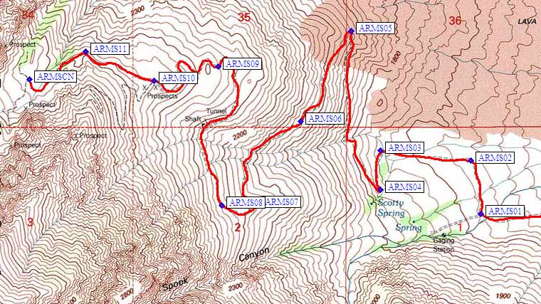
Next the road traverses southwest, through some very loose and lightweight pumice gravel. If you make it to waypoint ARMS06, you again have a place to park and turn around but you probably don't need it since the pumice has already turned back into regular rock and sand. At waypoint ARMS09 the road levels out and you may be blocked by snow early in the spring.
There is a tricky junction at ARMS10, which has lead more than one hiker astray: The old mining road ahead clearly switchbacks up the mountain, but THAT'S THE WRONG ROUTE and it dead-ends far above where you want to be with no good route back into the canyon. You want to drop slightly and go northwest to waypoint ARMS11 before turning southwest and parking in Armstrong Canyon proper (at or near waypoint ARMSCN). This is a party campsite, at over 8000', with lots of room to spread out among the big trees! Driving here is a pain, but saves you about 2500' of gain with a pack.
All went well till the first switchback (ARMS05) where
I failed on two tries on loose volcanic cinders,
backed into the switchback, and cleared the road
ahead for a final try. At this point a vehicle
came down, said the road got worse ahead, and suggested
I beg a ride from the bush campers back at Scotty Spring.
After some soul searching I decided this
made sense, but when I tried to drive
out of the switchback, the front wheels spun - I was
stuck in level volcanic rocks - a new
and unwelcome experience.
Started cranking the jack in the blazing Owens Valley
sun, but the jack just sunk into the loose, light rocks.
About this time a second vehicle came down, and
offered a tow, which was gratefully accepted.
On reaching the switchback I decided to take the 3rd
run before camping. With tires spinning and rocks flying
the aged Honda just made it past the loose cinder
stretch, and back to firm granitic sand. Decided to
launch Plan 'C', and
check out the road ahead, which was rumored to be
infested with rocks too high to straddle, too wide
to drive around, and buried to deep to dig out.
Turned out I could drive around them, though some
sagebrush did come in through the open windows.
Made it all the way to
36.94574,-118.34958
where a 2 ton rock makes a tight and rough squeeze
that was not to my liking. At this point the road
was just wide enough to turn the car around, pull
it off to one side, and clear out a tent spot on the
other side.
Useful Links:
Notes from Andy Martin (driving a 2WD Honda)
The grade was pretty constant,
and steep enough that it was tough to get moving uphill
if you stopped.