Chiquito Pass and Clover Meadow
Revised May 2011 - please send updates to the webmaster
For details of the roads and trailheads on the overview map, scroll down or click for:
Overview map of roads covered by this trailhead page:
North from Four Corners through Oakhurst, then northeast:
See GPS routes OAKHURST-QUARTZ, OAKHURST-CHIQUITO, and OAKHURST-CLOVER.
Take Hwy 41 north from Four Corners (waypoint 4CRNRS) through Coarsegold to the junction with Hwy 49 in Oakhurst
(waypoint OAKHST). In Oakhurst, you can pick up permits at the Yosemite Visitor
Center (waypoint YOSVIS) during business hours, or if you call ahead they
may tape them to the door around the side by the Coke machine. If you
don't have a GPS, the visitor center is across the highway from the Shilo Inn.
About 3.5 miles north of Oakhurst, Road 222 (which is actually
labelled Bass Lake Road) turns southeast toward Bass Lake at Yosemite Forks
(waypoint YOSFRK). Signs should be prominent, but if you see Sugar Pine
you've gone way too far up Hwy 41.
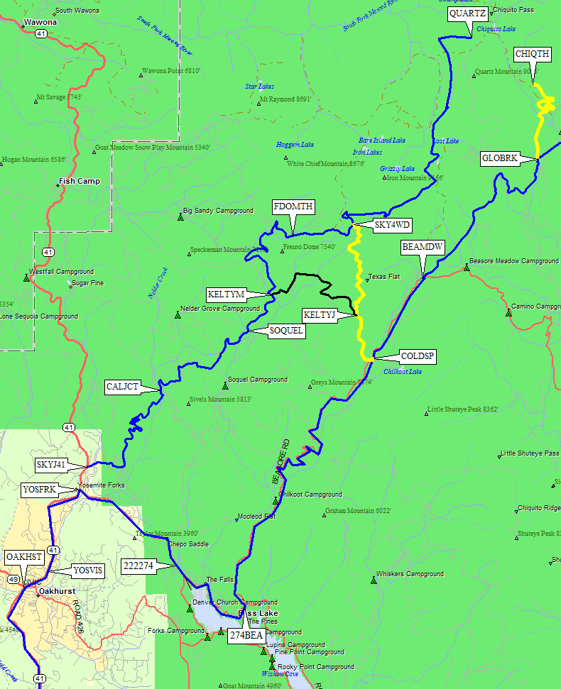
For Sky Ranch Road to Quartz Mountain trailhead for Chiquito Pass:
Stay on Hwy 41 for 0.6 miles north of Yosemite Forks (waypoint YOSFRK).
Turn right (east) on Sky Ranch Road (waypoint SKYJ41) and follow it east
then north into very extensive switchbacks. This road is mostly dirt, but
suitable for passenger cars. There is a shorter but much rougher 4WD alternative
to reach Quartz Mtn from Cold Springs, described below.
For Beasore Road to the main Chiquito and Clover Meadow trailheads:
Turn toward Bass Lake at Yosemmite Forks (waypoint YOSFRK), then 3.5 miles later turn
left on Road 274 (waypoint 222274), where you might not even notice the intersection
as the main road changes name and the road you were on angles off to the right.
Continue southeast to the north shore of Bass Lake (while 222
continues on the south shore) for 2.4 miles. On the north side of the lake,
you turn left on Beasore Road (waypoint 274BEA) which is marked with a green
sign that says Clover Meadow. The road now gets seriously narrow and winding
as you go north past several small turnoffs including Cold Springs
(waypoint COLDSP) and Beasore Meadows (waypoint BEAMDW).
Beasore Road actually goes to the Chiquto Pass trailhead (about 20 miles
northwest from where you get on it at 274BEA). Continuing past Globe Rock
(waypoint GLOBRK) to Clover Meadow (for Isberg and Mammoth) puts
you on the McCreary Cutoff, which may escape you because the main
road changes name when you don't turn off. Good maps will show a
significant loop through McCreary Meadow over to Minarets Road / Mammoth Road.
If you see McCreary or Clover Meadow, you've gone about 10 miles past the
Chiquto Pass trailhead!
Continuing northeast from Oakhurst: (not all waypoints are plotted here)
Chiquito Pass Trailheads:
NOTE: Chris Franchuk and Steve Rodrigues contributed the Quartz Mountain details.
See GPS routes OAKHURST-CHIQUITO, OAKHURST-QUARTZ, and BEASORE TO SKY RANCH.
Follow the directions above to either Sky Ranch Road or Beasore Road.
If you're going to the 'standard' Chiquito Pass trailhead (waypoint CHIQTH)
follow Beasore from Bass Lake. If you're going to the Quartz Mountain trailhead
(waypoint QUARTZ) you can either take Beasore to Cold Springs (waypoint COLDSP)
and then cut over to Sky Ranch, or you can take Sky Ranch all the way from
Hwy 41 until it ends (waypoint QUARTZ).
If you drive up Beasore, you're looking for Cold Springs or Globe Rock.
Cold Springs Summit (waypoint COLDSP) is a 4-way intersection 11.4 miles up
Beasore Road from Bass Lake (waypoint 274BEA). It's another 7.5 miles
to Globe Rock (waypoint GLOBRK). Just before Globe Rock there is a
"pavement ends" sign, but the pavement doesn't actually end for
almost two miles - it goes right past the Chiquito Pass turnoff to the
Upper Chiquito Campground.
At GLOBRK, turn north off what appears to be the main route and stay on
Beasore Rd 2.5 miles north to the standard Chiquito Pass trailhead (waypoint CHIQTH).
The 'standard' Chiquito Pass trailhead (waypoint CHIQTH) is 1000 feet lower than
the Quartz Mountain trailhead (waypoint QUARTZ) but it's easier to drive there
because it's almost all paved.
Beasore turns into the yellow line going north to waypoint CHIQTH on the maps above and below.
The main road (McCreary Cutoff), shown in blue or red east of GLOBRK, heads east to the Clover
Meadow Ranger Station (waypoint CLOVRS). It's comforting to have a GPS with
waypoint GLOBRK pre-entered so you can't miss the turnoff.
Just a bit past Globe Rock is Upper Chiquito Campground, where you could spend the night.
On the other hand, the camping situation at the trailhead is excellent, with a few
fire rings and tons of parking in among the big trees. No fees, no facilities.
This is national forest, not a park, so the rules are a lot looser. 3 miles up the
trail from CHIQTH is Chiquito Pass, where you enter Yosemite without the crowds.
Franchuk documented the Quartz Mountain shortcut from Cold Springs (waypoint COLDSP)
to Sky Ranch Road (waypoint SKY4WD) which is 4WD or at least high clearance
(see route BEASORE TO SKY RANCH, shown in yellow on the map). Rodrigues took
Sky Ranch Road all the way from Hwy 41 (waypoint SKYJ41) and said it was fine
for any passenger car. He came out via the Franchuk shortcut:
"This road is very bouncy and bumpy, albeit passable in my Subaru Forester
(7.5 inch ground clearance), although I did bounce and hit the car ceiling at one point!"
You can avoid the worst part of the shortcut by detouring over to Kelty Meadow
on the way in (from waypoint KELTYJ to KELTYM, shown in black on the map)
then following Sky Ranch around Fresno Dome to the Quartz Mountain trailhead
(waypoint QUARTZ).
Quartz Mountain shortcut: At Cold Springs Summit (waypoint COLDSP)
turn left onto unpaved Road 6S10S (the yellow line on the map below).
In about 1.5 miles (waypoint KELTYJ) meet a road on the right that may be
signed for Quartz Mtn (at this point follow signs for Quartz Mtn to trailhead).
You have two options, the first being shorter but on a rougher road:
Chiquito and Quartz Mtn trailheads for Chiquito Pass:
Clover Meadow Ranger Station and Isberg/Mammoth Trailheads:
See GPS route OAKHURST-CLOVER
Beasore does not go to Clover Meadow, but the main road does! When you
pass Globe Rock the main road (shown in red on the map below) becomes the
McCreary Cutoff and soon changes from pavement to dirt suitable for all vehicles.
It's comforting to have a GPS with waypoint GLOBRK pre-entered, but if you just
follow the main road to Clover Meadow you don't need to worry about that turnoff.
Follow the directions above to Beasore Road.
As you drive up Beasore look for Cold Springs and Globe Rock.
Cold Springs Summit (waypoint COLDSP) is a 4-way intersection 11.4 miles
from Bass Lake (waypoint 274BEA). It's another 7.5 miles
to Globe Rock (waypoint GLOBRK). Just before Globe Rock there is a
"pavement ends" sign, but the pavement doesn't actually end for
almost two miles - it goes right past Globe Rock (the Chiquito Pass turnoff)
to the Upper Chiquito Campground.
6 miles beyond Globe Rock are the Jackass Flat (waypoint JACKAS)
and Norris Lake (waypoint NORRIS) trailheads, which head north to the
south side of Madera Peak and might provide a good alternate approach
to Gale and Sing peaks (normally climbed via Chiquito Pass).
Beyond that is the intersection with Minarets Road (waypoint MINJCT)
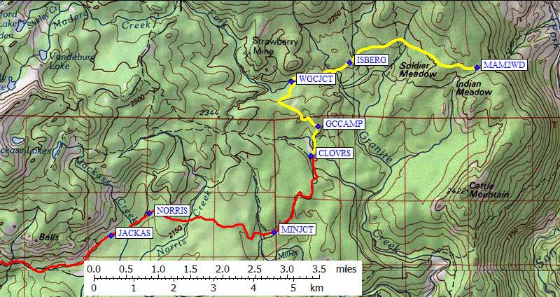
and finally the Clover Meadow Ranger Station (waypoint CLOVRS),
which is about 13 miles from Globe Rock and about 2.5 hours drive from Madera.
If you keep going on the yellow line below, you come to the Isberg Pass
(waypoint ISBERG) and Mammoth (waypoint MAM2WD) trailheads.
The Clover Meadow ranger station (waypoint CLOVRS) is only open in
the summer. It is where you pick up wilderness permits for all area
trailheads, unless you goto one at the Yosemite Visitor Center in
Oakhurst (waypoint YOSVIS). It's about 6 miles from the ranger station
all the way to road's end at the Mammoth trailhead (waypoint MAM2WD).
The road is fine for passenger cars but is not paved.
From CLOVRS, the road goes north past the Granite Creek Campground turnoff
(waypoint GCCAMP) where some mapping software shows the road going right
but in fact the road goes left. Follow the sign for Isberg Pass and
Mammoth trailheads. From the campground turnoff you'll go northwest and
then northeast before crossing the West Fork of Granite Creek and turning
right (east) at another well-marked junction (waypoint WGCJCT). (My notes show
the sign here says it's 2 miles to the Isberg trailhead and 4 miles
to the Mammoth trailhead, but that may be measured from the campground.)
Less than a mile from the west fork junction (WGCJCT), the real road
diverges sharply from the road shown on the 7.5' topo maps. There is no
sign and no junction, and my GPS track log is plotted on the map below.
The road is in the trees, so the track log may not be perfect!
The current road skirts Soldier Meadow and Indian Meadow on the north,
staying high and dry (probably to avoid an area that washed out).
The Isberg Pass trail crosses the road just west of the East Fork
of Granite Creek, at about 7100' (waypoint ISBERG), where there is
trailhead parking with no facilities. This trail comes from the
Granite Creek campground and goes north to Isberg Pass on the southern
edge of Yosemite. You can use it to climb peaks near Red or Gray, but
most people come this way to climb Foerster, Electra, and Rodgers.
Hemlock Crossing features a beautiful waterfall and pool, and
continuing up-canyon from there gets you to a stunning valley
between Mt Davis and Rodgers Peak, or a western approach to
Ritter and Banner via Lake Catherine.
The Mammoth Trailhead is where 4 trails converge at 7500' on the 7.5'
topo map (waypoint MAM2WD). There are no facilities, it's dusty, and
two of the trails are apparently open to 4WDs (to Green and Cattle Mtn)
so you can expect a less than perfect trailhead experience during
hunting season. The trailhead sign is 50 yards from the parking area,
on the ridge, with a sign indicating Reds Meadow and Sheep Crossing.
A good trail drops east to Sheep Crossing on your way to Iron Mountain,
Granite Staircase, etc.
Useful Links:
I haven't actually been there, so please let me know if anything got lost in the translation!
(yellow line to SKY4WD is not suitable for passenger cars, but CHIQTH is OK for any vehicle)