Sonora Desert Trailheads
(East of Los Angeles, south of Flagstaff)
Revised 12 Apr 2012 - please send updates to the webmaster
|
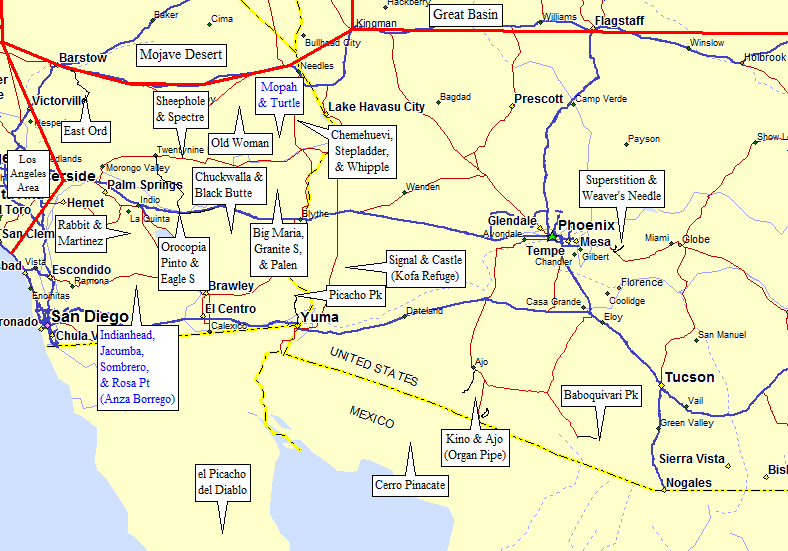
Sonora Desert Trailheads (click on any black label)
| ||
| waypoint | trailhead | comments |
| EORDTH | East Ord Mtn | SE of Barstow in the Lucerne Valley |
| RABATH | Rabbit Peak | Santa Rosa Mountains, SE of Palm Springs and W of Salton Sea |
| MAR2WD MAR4WD | Martinez Mountain | Santa Rosa Mountains, SE of Palm Springs and W of Salton Sea |
| SHPATH SHPBTH | Sheephole Mtn | north of Twentynine Palms |
| SPEC2W | Spectre Point | east of Twentynine Palms (in Joshua Tree) |
| OROCAR ORO2WD ORO4WD | Orocopia Mtn | Orocopia Mountains, between Chiriaco Summit and the Salton Sea |
| EAGLET | Eagle Mtn South | DPS Eagle Mtn #1, between Chiriaco Summit and Twentynine Palms (in Joshua Tree) |
| PINTOT | Pinto Mtn | between Chiriaco Summit and Twentynine Palms (in Joshua Tree) |
| CARBTH | Old Woman Peak | Carbonate Gulch approach, near Essex, west of Lake Havasu |
|
BLK2WD BLK4WD BLKDPS CHUK2W CHUK4W CHUKPC | Black Butte Chuckwalla Mtn | Chuckwalla Mountains, north of the Salton Sea |
| BIG2WD BIG4WD PALATH PAL4WD PALDPS GRNATH GRNBTH | Big Maria Mtn Palen Mtn Granite Mtn (S) | north of I-10 between Desert Center and Blythe |
| STEPTH CHEMTH WHIPTH | Stepladder Mtn
Chemehuevi Pk Whipple Mtn | Chemehuevi Valley, west of Lake Havasu |
| PICWTH | Picacho Peak | western approach near Picacho State Rec Area (yes, Picacho Peak means 'Big Peak Peak') |
| SIGETH CASDTH | Signal Peak Castle Dome Peak | in the Kofa National Wildlife Refuge (camping at trailhead is free) |
| SUPRTH | Superstition Mountain | high point of the Superstition Mountains (in a housing tract) |
| WEAVTH | Weaver's Needle | Weaver's Needle trailhead is on a good dirt road (camping at trailhead is free) |
| TRCAMP BPCAMP | el Picacho del Diablo | western approach Mexican national park (don't forget your passport!) |
| PINATH BIOSPH | Cerro Pinacate | in Mexico's Biosphere Reserve (don't forget your passport!) |
| KINOTH | Kino Peak | in the Organ Pipe Cactus National Monument NOTE: May not be safe or legal, enter at your own risk! |
| AJOTH | Mount Ajo | in Organ Pipe Cactus National Monument near the visitor center |
| BABOTH | Baboquivari Peak | via indian reservation, dirt road suitable for any vehicle (camping at trailhead may be free) |
Useful Links: