Mineral King from Three Rivers
Revised 18 May 2014 - please send updates to the webmaster
GENERAL NOTES:
Waypoints between Three Rivers and Mineral King are plotted to clarify the text below.
Follow the MINERAL KING route waypoints, as described below.
Take Hwy 198 northwest through the town of Three Rivers (waypoint 3RIVER),
following signs for Sequoia / Kings Canyon national park. At the waypoint
you will find a post office, Holiday Inn, liquor store, etc. A mile north
on Hwy 198 are more restaurants (including the Noisywater Cafe) and more
filling stations. Tourist shops abound as you wind along the Kaweah River.
(Three Rivers is actually the confluence of the main Kaweah River and
the North Fork.)
Leave Hwy 198 on the Mineral King Road (waypoint 198MIN). This turn is
marked by a small green sign reading 'Mineral King 25 miles', but just
after you make the turn there is a much larger brown sign next to a
fire station. The road now becomes amazingly winding and slow. There
are often cows on it and a steep dropoff, so race car drivers beware.
From 198, it is only 25 miles to the Mineral King ranger station and
most people take an hour to drive it. Follow the main road, which is dirt
at times but does not require high clearance. Take the left fork at
Hammond Road (waypoint HAMOND), following the sign to Mineral King.
Note that the road bears southeast as it enters the East Fork Kaweah River
canyon beyond Red Hill (waypoint REDHIL). Cross the East Fork on a 1920's
bridge near Oak Grove (waypoint OAKGRV), take the right fork at waypoint
GRUNIG (near Grunigen Creek, where the left fork is a dirt road that
leads to the Milk Ranch Peak lookout tower) again following a Mineral King
sign.
Continue to the entrance fee booth at the Lookout Point Ranger Station
(waypoint LOOKPT). From there the road actually straightens just a bit,
but soon you are at the gate (presumably closed in winter) where the
pavement ends (waypoint MKGATE).
John Clark remarks:
The gate is indeed closed in winter. Check w/National
Park Service at Ash Mtn 559-565-3341 for precise dates of closure.
From here to the trailhead is dirt road except where they've paved it
to keep dust down near campgrounds and houses.
See below for trailhead and ranger station details on a topo map.
Just before the low-altitude campground at Atwell Mill (waypoint ATWELL)
the Paradise trailhead leads north to Paradise Peak, a possible jumping
off point to Castle Rocks. From here you can also get to Bearpaw Meadow
and the High Sierra Trail the hard way by crossing the Middle Fork of
the Kaweah River. The upper (unmarked) entrance to Atwell Mill campground
is the trailhead for Hockett Meadow (leading south to Mountain Home
State Forest if you go far enough) and has a steel bear box for general
use (not in a campsite).
There may be cabins for rent at Cabin Cove or Silver City, there is
supposed to be a post office at Silver City (which I've never seen)
and there is a general store and/or restaurant at Silver City
(waypoint SILCTY) which seems never to be open when I'm there.
John Clark remarks:
There is no formal post office at Silver City,
but you can mail and receive letters at the Silver City Store.
Rental cabins are only available at Silver City.
As are hot showers and meals most of the year.
See SilverCityResort.com
My dog and I live at Silver City in summer. Good climbing to you.
Eventually you reach the higher campground at Cold Springs
(waypoint CLDSPR). A trail leads south from waypoint HORSEC to
Horse Creek and the Hockett Plateau, but climbers seldom go that way.
Permits can be picked up after listening to a long lecture at the Mineral
King Ranger Station (waypoint MINKNG). Across from the ranger station is
a wooden shack where you can leave trailhead food, but there are no bear
lockers at the trailheads themselves. Strangely, both trailheads have
pay phones!
Parking at the high trailheads is dangerous in spring but
seems to be OK in the fall. One theory is that marmots can't get
enough salt from native plants until July. Another theory is that they
have food cravings during lactation. Either way, June trips often end
with chewed wiring and radiator hoses. Take chicken netting to protect
the underside of your car (tarps do NOT work - read on!).
Remember that marmots tunnel for a living so just putting up a fence won't work.
You have to drive onto it and wrap it around the vehicle all the way above the wheel wells.
Or just wait until the fall when there don't seem to be any problems.
Putting out salt licks would be a violation of federal law.
A ranger told me (in July 2011) that even during
high snow years marmots stop chewing on cars by early July.
Timber Gap and Sawtooth Pass
Eagle Creek, Mosquito Lakes, Franklin Pass, or Farewell Gap Useful Links:
Dan Baxter
suggests: "You might want to add that spraying some coyote urine around the car is
also very effective, and is a lot easier than wrapping one's car. I got
some scratches on the car at the White Mtn trailhead from their chicken
wire. [You can buy it] at Amazon.com, Lowes, etc.
Cheapist is probably $12.95 at Walmart.com. I
bought a bottle and put it into a spray bottle.
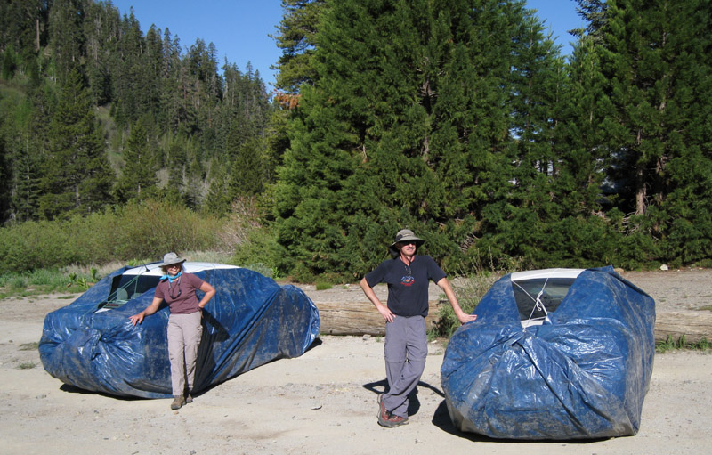
The picture above was taken mid-June 2008, NOT a high-snow year.
Marmots defeated the tarps on both cars.
One tarp was chewed through.
On the other car one or more marmots jumped up on the
car and wormed between the tarp and the car (based on footprints)
apparently exiting the same way. Both tarps had marmot turds under
the car inside the tarp. Not much damage done, however. They seemed
to be mostly interested in the fiberglass under the hood (sound deadening)
for lining their nests. A decade earlier my Honda had wiring chewed
in half and foam insulation stripped off the air conditioning tubing.
There are reports that marmots (unlike dogs) do not die from drinking
radiator fluid but they do get wobbly.
There are two main climber trailheads near Mineral King:
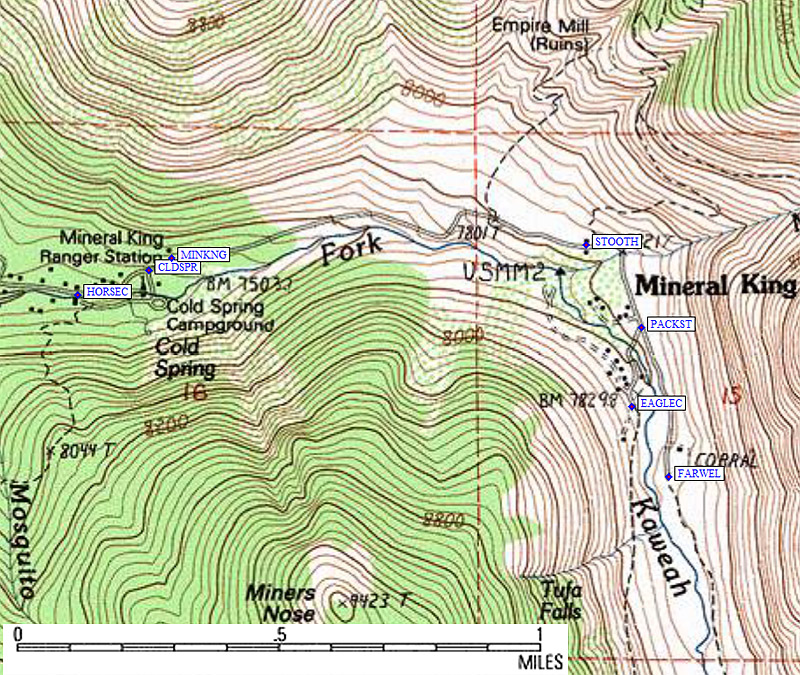
At the Sawtooth Pass trailhead (waypoint STOOTH) there is an outhouse and
parking, even a pay phone to call for a tow when marmots eat up your car.
This is the place most climbers start.
Continue past the Sawtooth parking lot, follow the road
as it bends south, and take the right fork at waypoint PACKST. The left
fork is where most climbers want to go, but is private pack station parking
only. The public parking lot (waypoint EAGLEC) is at the end of the right
fork and is the trailhead for Eagle Creek (where few climbers go) on the west
side of the East Fork of the Kaweah River. To get to the Franklin/Farewell
trail on the east side of the East Fork (waypoint FARWEL), you can either
jump the stream via a use trail halfway between the parking and the
Eagle Creek trailhead sign, or go back down the road and cross the
stream on the bridge (then walk past the pack station).