CalTrain Stations
Revised 13 Apr 2012 - please send updates to the webmaster
Official CalTrain schedules are available online - check frequently in case they change! |
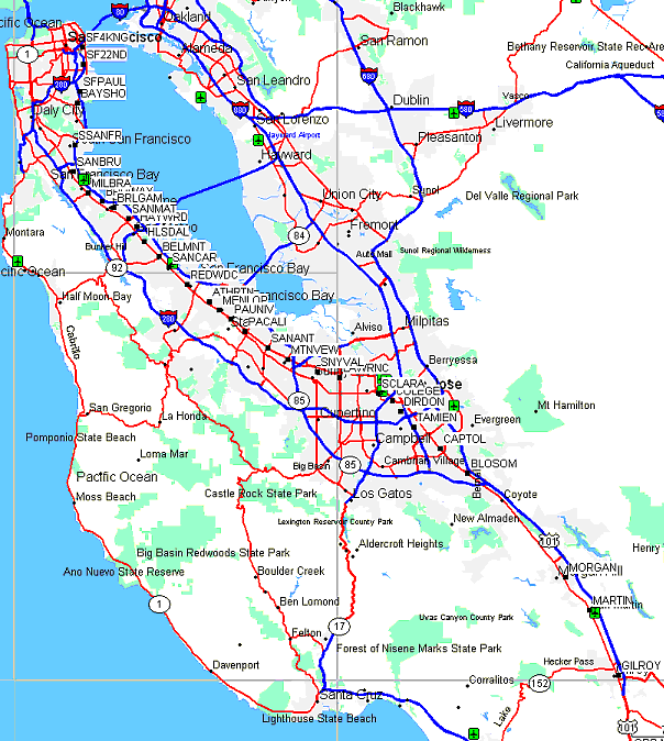
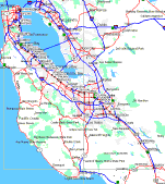
The maps above the whole area with low resolution and higher resolution regions where you can see plotted waypoints, or click on the interactive map link above for more detail. Use the map menu to switch to map or street view and get directions to any waypoint. Don't trust the intersections listed below to point exactly at the station - it's just somewhere near that. |
| NOTE: Field checked waypoints will be MUCH more accurate than either MapSource or Google intersection locations. The big database companies often have a storage shed or the ticket office as their waypoint, whereas the waypoints noted as 'verified' represent the center of the boarding area or other known location and will be accompanied by notes about the layout of the station. Stations and boarding areas are often very long with more than one parking lot or road access point. When meeting someone, be sure to specify which side of the tracks and north or south end of the boarding area. |
The unverified waypoints below, and all images, are from Garmin MapSource City Navigator (NAD83 decimal degrees).
| Zone | Station Name | Location Description Intersection locations may not be as accurate as the GPS waypoints! | GPS Waypoints |
|---|---|---|---|
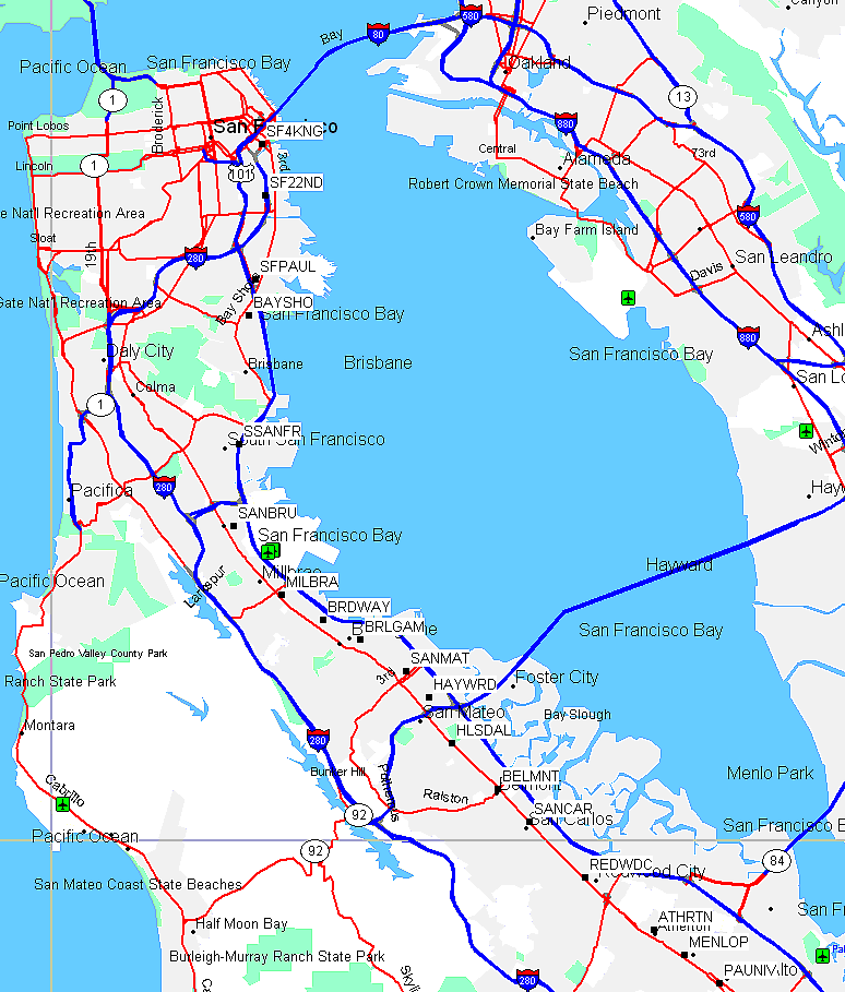
| 1 | San Francisco | 4th & King Sts, San Francisco | SF4KNG |
| 22nd St. | 22nd St & Pennsylvania Ave, San Francisco | SF22ND | |
| Paul Ave. | Paul Ave & Gould St, San Francisco | SFPAUL | |
| Bayshore | Tunnel Ave near Lathrop Ave, Brisbane | BAYSHO | |
| South San Francisco | Dubuque & Grand Aves, South San Francisco | SSANFR | |
| San Bruno | Sylvan Ave & Huntington Ave, San Bruno MapSource and TransitInfo disagree! | SANBRU | |
| 2 | Millbrae | Millbrae Ave & Rollins Rd, Millbrae This station connects to the BART station for SFO airport and north/east bay destinations. Station is on California SE of Millbrae, SW of Hwy 101. | MILBRA |
| Broadway | Broadway & California Dr, Burlingame Watch out - only a FEW TRAINS stop here! On California at Broadway. | BRDWAY | |
| Burlingame | Burlingame Ave & California Dr, Burlingame On Broadway, NW of Howard. | BRLGAM | |
| San Mateo | First Ave & Main St, San Mateo Near 2nd Ave. | SANMAT | |
| Hayward Park | Concar Dr & Highway 92, San Mateo Watch out - only a FEW TRAINS stop here! Waypoint is center of platform on east side of tracks. The only parking lot or car access is on the east, with a surface pedestrian crossing to the southbound lanes. Exit Hwy 92 at Delaware, go north to Concar, turn west and follow Concar until just before it turns left under the freeway, parking lot is on the right. | HAYWRD waypoint | |
| Hillsdale | El Camino Real & Hillsdale Blvd, San Mateo Waypoint is center of platform, on the railroad bridge over Hillsdale Blvd. There are two separate parking lots, both with entrances on El Camino Real, one north of Hillsdale and one south of Hillsdale (access is from the Hillsdale on/off ramps from northbound El Camino). The pedestrian walkway along the tracks (across the railroad bridge) is the only connection between the two lots. | HLSDAL waypoint | |
| Belmont | El Camino Real & Ralston Ave, Belmont Waypoint is center of platform, on the railroad bridge over Ralston Ave. There are two separate parking lots, both with entrances on El Camino Real, one north of Ralston and one south of Ralston. Access to the both lots is from El Camino only, the first stop light on El Camino in each direction from Ralston. The passenger pickup waiting area is accessible only from northbound El Camino immediately north of Ralston, on the west side of the tracks, and is not connected to any parking lot. There is no legal place to stop on the east side of the tracks (Old County Road) even though there is a large pedestrian mall there (between Masonic and Ralston). The pedestrian walkway along the tracks (across the railroad bridge) is the only connection between the two lots. | BELMNT waypoint | |
| San Carlos | El Camino Real & San Carlos Ave, San Carlos On El Camino at San Carlos Ave, SE of Holly (which connects to Hwy 101). | SANCAR waypoint | |
| Redwood City | James Ave & California St, Redwood City Next to Sequoia Station shopping center, south of Broadway and NE of El Camino in downtown Redwood City. | REDWDC waypoint | |
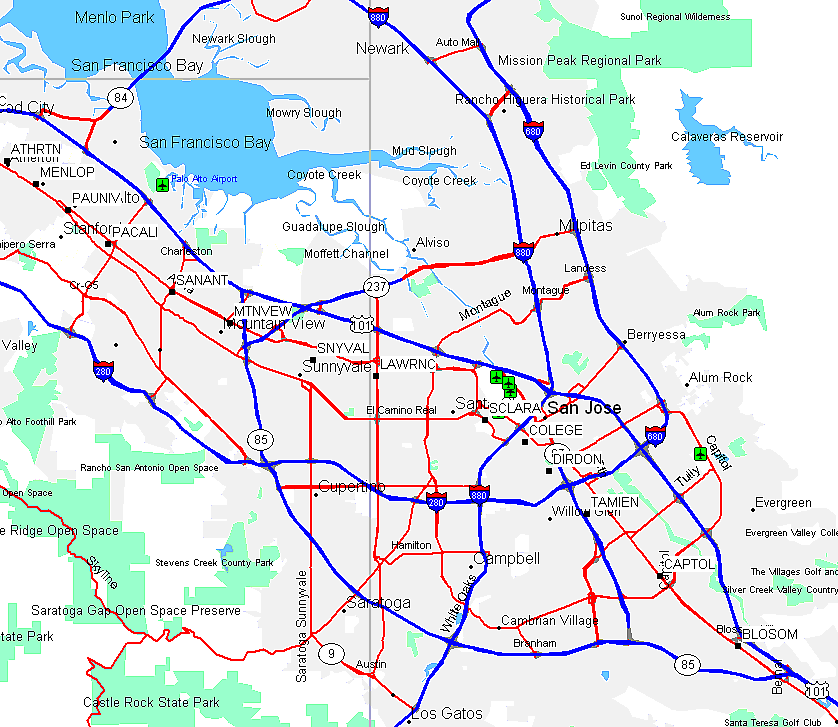
| 3 | Atherton | Fair Oaks & Dinkelspiel Station Lanes, Atherton At Fair Oaks, NE of El Camino. | ATHRTN waypoint |
| Menlo Park | Santa Cruz Ave & Merrill St, Menlo Park At Santa Cruz, NE of El Camino. | MENLOP waypoint | |
| Palo Alto | University Ave & Alma St, Palo Alto Waypoint is on the tracks, halfway between University Ave and Lytton Ave. The platform extends south over University and probably a bit beyond. The big station building is actually southwest across the tracks from Alma. (The old baggage shed is now a bike parking, rental, and fixing place during business hours.) The station is on the northwest side of University. If you drive southwest on Lytton you cross Alma and end up directly in ONE OF THE FOUR the parking lots. ANOTHER lot is directly across the tracks, accessed from University by turning northeast on Mitchell Lane (the only street between El Camino Real and Alma Street). There are actually 4 parking lots, one in each quadrant, but no one has sent a description of how to reach the southern two! You can't get from one lot to the other on the same side of the tracks without going out onto a street or walking down the loading platform. On the non-Alma side, the 'street' (Mitchell) is not very big, more of an access loop that just goes to the train station (and parking) and the Red Cross and McArthur's restraunt. There is a pedestrian tunnel (or two) under the tracks, and you can't see someone waiting in the other parking lot unless you go there. | PAUNIV waypoint | |
| California Ave | Park Blvd & California Ave, Palo Alto NW of Oregon Expressway / Page Mill, at Alma. | PACALI waypoint | |
| San Antonio | Showers Dr & San Antonio Rd, Mountain View SE of San Antonio (which connects to Hwy 101), at Central Expressway. | SANANT waypoint | |
| Mountain View | View St & Evelyn Ave, Mountain View This station connects to Santa Clara Light Rail for Silicon Valley destinations. East of Moffett/Castro, at Central Expressway. | MTNVEW waypoint | |
| Sunnyvale | Evelyn Ave & S Frances St, Sunnyvale On Evelyn, East of Mathilda. | SNYVAL waypoint | |
| 4 | Lawrence | Lawrence Expwy & Lawrence Sta Rd, Sunnyvale Under the Lawrence Expressway overpass, South of Central Expressway. | LAWRNC waypoint |
| Santa Clara | El Camino Real & Railroad Ave, Santa Clara South of Brokaw/Benton, on El Camino. | SCLARA waypoint | |
| College Park | Stockton Ave & Emory St, San Jose Watch out - only a FEW TRAINS stop here! SE of Hedding on Stockton. | COLEGE waypoint | |
| San Jose Diridon | Cahill & W San Fernando Sts, San Jose this is an AMTRAK station also | DIRDON | |
| Tamien | Alma & Lick Aves, San Jose | TAMIEN | |
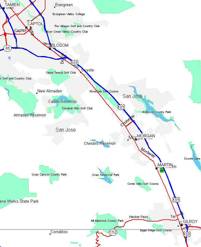
| 5 | Capitol | Monterey Hwy & Fehren Dr, San Jose | CAPTOL |
| Blossom Hill | Monterey Hwy & Ford Rd, San Jose | BLOSOM | |
| 6 | Morgan Hill | Butterfield Blvd & E Main Ave, Morgan Hill | MORGAN |
| San Martin | Monterey Hwy & San Martin Rd, San Martin | MARTIN | |
| Gilroy | Old Gilroy & Monterey Sts, Gilroy | GILROY |
Overview:
Northern Section (San Francisco to Menlo Park):
Middle Section (Menlo Park to San Jose):
Southern Section (San Jose to Gilroy):
Useful Links: