Nine of us participated in this late-August trip to the central Palisades, with four peaks on the agenda and everyone free to focus only on those peaks they "needed." Participants came from both the PCS and SPS, and included Lisa Barboza (trip leader), Daryn Dodge, Greg Gerlach, Sandra Hao, Corrine Livingston, Kathy Rich, Shane Smith, Bob Wyka, and myself (Jim Ramaker).
We met Friday morning at the Glacier Lodge trailhead for the short hike up to Willow Lake, followed by a brushy cross-country battle up the creek that runs due west. We were aiming for Lake 12,250 southeast of Mt. Gayley, but found a nice camp short of there in a split-level meadow, with a sandy upper meadow for camping, and a lush lower meadow with a creek for water. Late-afternoon happy hour was impressive, with brie, cheddar, and goat cheeses, assorted crackers, heirloom tomatoes from Lisa's garden, mozzarella with fresh basil leaves, and of course a choice of wine.
On Saturday we were up at 5 and rolling at 6, heading southwest up the talus and moraine basin toward Mt. Sill (14,160). A broken cliff rings this basin about halfway up, and we climbed it via a rubble-filled class-3 slot that was a bit dodgy for a group of nine at 7 a.m. Above that the scenery was amazing, with the Palisade giants of Norman Clyde, Pal Crest, Jepson, Sill, Gayley, and Temple Crag stretching from left to right in a vast semicircle.
Our route up Sill was the L-Shaped Glacier (LSG), which we hoped to climb via class-2 boulders on its right, avoiding the downsloping class-3 slabs on the left. But getting to the class-2 rocks required crossing the lower arm of the L, and after much pre-trip discussion about conditions in this low snow year, we had decided not to bring ice axes and crampons. Lisa and I clawed our way halfway across the icy lower arm of the glacier using ski pole tips (her) and a sharp rock (me), then realized that the entire group would not be into this and so gave up and went over to the left-side route.
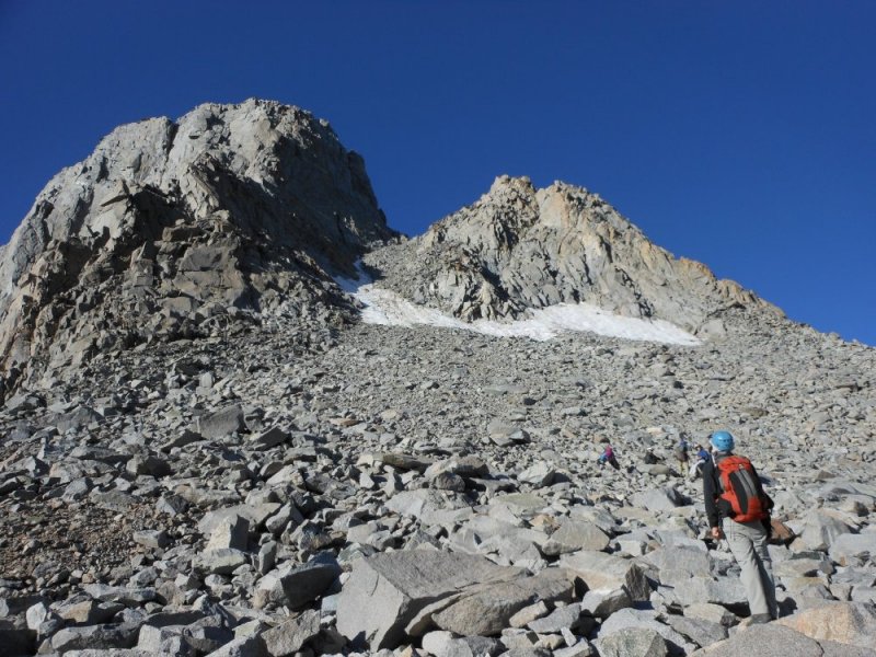
Here is the team approaching Mt. Sill (14,160). Our route went up the rocks on the left side of the snow to the prominent notch, then around to the left and up to the summit (photo by Kathy Rich):
Some care was required on the left-side slabs, as a fall would send you sliding down onto the glacier, but it wasn't really hard or unsafe. The LSG is a shadow of its former self, with the upper arm of the L now just a few feet wide. A few more years of global warming and the upper arm will probably disappear completely in the summer.
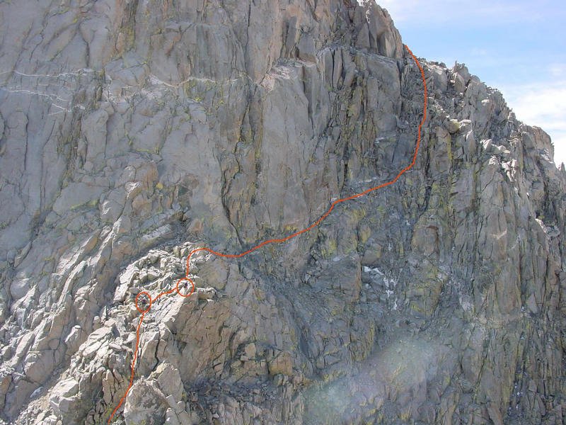
Above the LSG, we found the class-4 section above the saddle with Apex Peak to be overrated -- we thought it was all class-3 with maybe a couple of class-4 moves near the end (photo by Bob Burd from snwburd.com/bob):
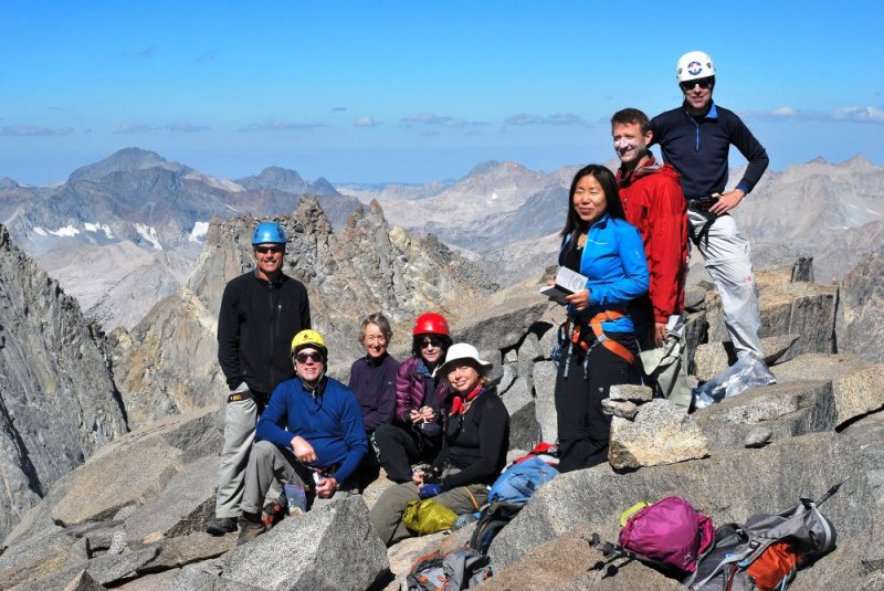
After rounding the corner, we climbed up and left on solid class-3 boulders to the summit, where we arrived at 10 a.m. Left to right: Greg Gerlach, Bob Wyka, Kathy Rich, Corrine Livingston, Lisa Barboza, Sandra Hao, Shane Smith, and Jim Ramaker (photo by Daryn Dodge):
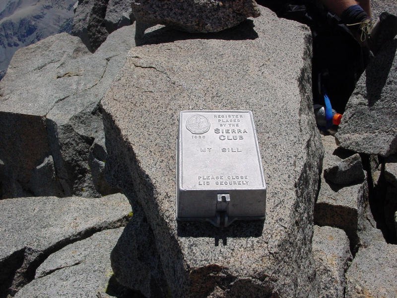
The mysterious scorched-earth campaign against Sierra summit registers has now reached Mt. Sill -- not only were all of the register booklets gone, but so was the classic aluminum register box, placed by the Sierra Club in 1935 (photo by Bob Burd in 2003 from snwburd.com/bob):
| Back down at the Apex saddle, five members of the team headed for Polemonium (14,080). Here is Daryn's report: |
| Greg, Sandra, Kathy, Shane, and I crossed the ridge between Sill and Polemonium with no difficulty until the last 100' or so, where a chasm separated us from the peak. We could not downclimb it, so we dropped a little off to the left (south) and found a narrow chute. We descended the chute for about 20', where we were able to climb out of the chute towards the peak via a tight class-3 chimney. Ducks marked the top of the chimney. From there we climbed to the base of the summit pinnacle, and about 15' of class 3-4 climbing got us onto the narrow ridge below the steep, short knife-edge leading to the top. At that point we roped up, and I led a short pitch of exposed class 3-4, going left around a small gendarme and on up to the summit, then set a fixed line for the others to join me. An aluminum register box placed in 1991 was bolted to the summit rocks, but nothing was inside it. The traverse from the Apex saddle to Polemonium and back took about 3.5 hours. |
After Daryn's party headed for Polemonium, Bob, Corrine, Lisa, and I descended the LSG and headed for the nearby "Yellow Brick Road" route on Mt. Gayley (13,510). On the way down, we chatted with a group of five young weight-lifter types storming upwards in tank tops. Bob didn't "need" Gayley, so he napped on the slabs at Glacier Notch, while Corrine, Lisa, and I headed up. We stayed well to the right of the ridge until we were about 3/4 of the way up, then eased onto the ridge crest to finish up -- a very short and pleasant climb on solid class-3 rock.
At the summit, we had one of those Sierra mountaineering moments -- we could clearly see our five friends a mile away on the summit of Polemonium, while the muscle-man team waved to us from the summit of Sill. We could also see climbers on the crest of the U-Notch, and a solo climber ascending the Palisade Glacier. After a long rest on the summit, Lisa, Corrine, and I started down about 1:30. We made a rookie mistake on the way down, staying on the ridge crest because it had nice rock, but failing to lose any significant elevation. We soon got cliffed out and had to reclimb about 100', drop down to the left (looking down), and get back on the correct route. After picking up Bob Wyka, we meandered our way back to camp enjoying the scenery, then washed up and took naps. Kathy returned around 6 p.m., and the remainder of the Polemonium team wandered in about an hour later, with Daryn having climbed Gayley on the way back to make it a three-peak day for him.
On Sunday, Lisa, Sandra, Bob, and I needed Temple Crag (12,976), and we again got up at 5 and got moving by 6, while the others slept in. The east-facing gully mentioned in Secor does not seem to exist, so we climbed an obvious short gully with a chockstone near the southeast base of the peak. From the top of this gully, we crossed a second gully, then crossed a class-3 rib into a third gully, where there was a cliff just below us. We climbed up this gully for 100' of class-3 until it steepened, crossed yet another rib, and finally arrived on the broad low-angle scree slope on the upper east side of Temple Crag.
We walked up this slope to the apparent high point, where we suddenly encountered some really big air, with the summit 40' away along a narrow, exposed ridge. Some parties have roped up here, but the rock seemed solid, so we proceeded. Halfway across, I looked down about 50' and the ridge seemed to be no more 10' wide at that point, and dropping away into oblivion below. While the holds are good in this section, I would not call it class-3 -- if you slip or if a hold breaks off, you're done for.
We topped out at 8 a.m., called down to our friends in camp, and then reversed our route. Hiking out to Willow Lake, we decided to stay on the south side of the creek as much as possible, which turned out to be a mistake. At times we found a good use trail, but it always ended quickly and gave way to nasty brush, often combined with big boulders and/or steep slopes. I think the deal here is just to stay on the large talus blocks on the north side of the creek. Strenuous, but at least you can see where you're going, plan a route, and for the most part, avoid the dreaded brush. At 2 p.m. we stumbled onto the South Fork trail with great relief, and by 3:30 we were at the cars.