|
Static map of the entire trip. Climbing waypoints are below, with GPX and interactive map links. |
See the trailhead page
for driving directions with maps and waypoints. See also my 2010 trip report for a snowy winter trip. |
|
|
Thursday, Jan 12
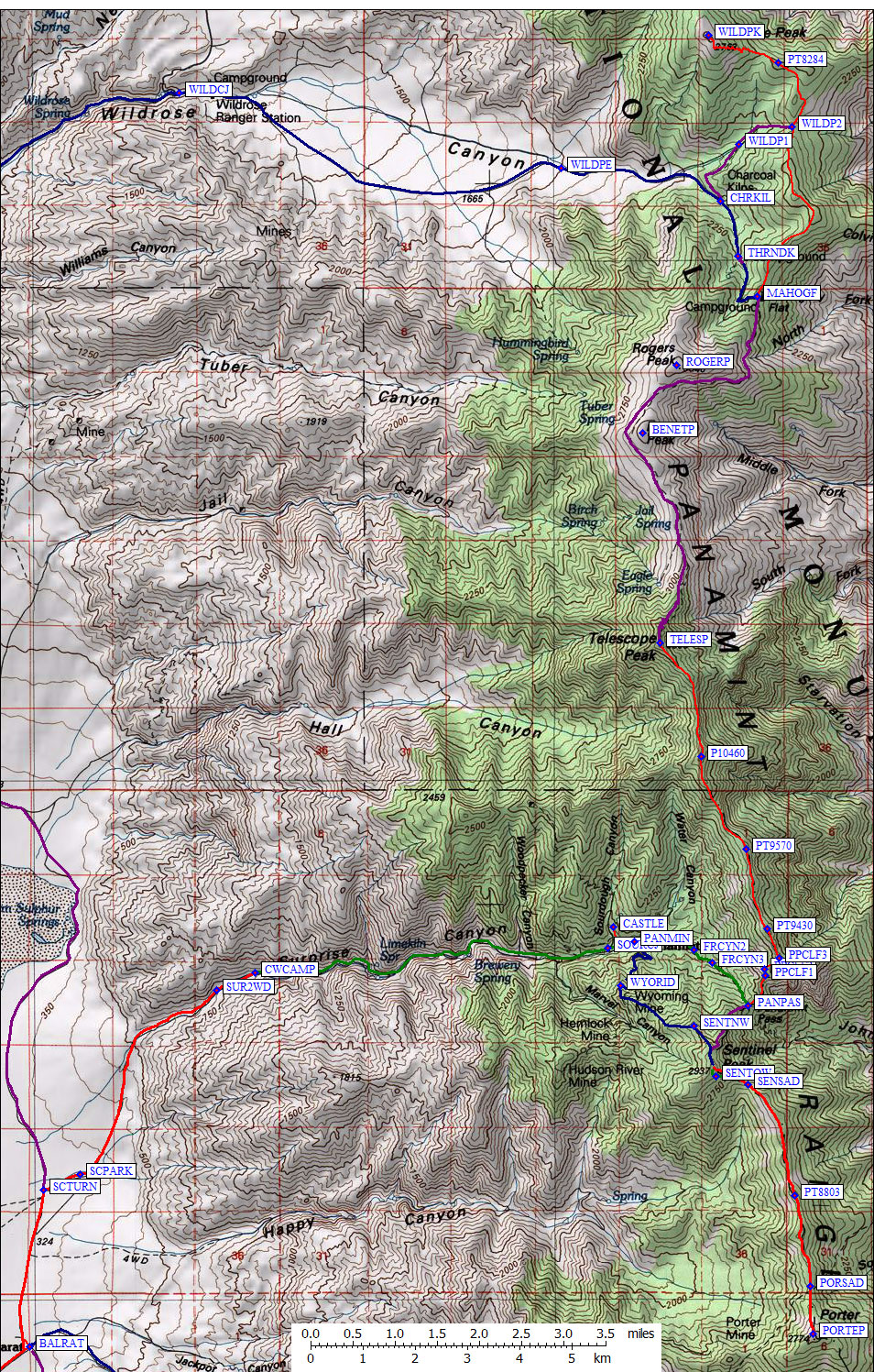
Matt scheduled a trip up Surprise Canyon, with time to poke around the mine ruins of Panamint City, and I figured this was my chance to finish connecting the high points of the Panamint Range (from Porter to Wildrose). The day before the group trip started, I dayhiked Wildrose Peak from the Thorndike Campground via Mahogany Flat (see the trailhead page). I couldn't drive all the way to the end of the road because there were patches of ice, but without the ice any passenger car would have made it. Running the ridge to Wildrose Peak (waypoint WILDPK) is uncomplicated but with lots of up and down. Eventually I intersected the trail from the Charcoal Kilns (waypoint WILDP2), which is about where I met a ranger (yes, they do patrol!) who asked if I had first driven over to Stovepipe Wells (an hour each way) to get the optional permit. Sorry, no. The top was cold and windy with no snow at all. There were patches up to a foot deep down to 7 or 8k, but only where the sun don't shine. Part of why I climbed Wildrose was to see how much snow there was on the shaded slopes of Telescope: Enough to melt for overnight drinking water? Enough to need an ice axe? |
Furnace Creek from the shoulder of Wildrose
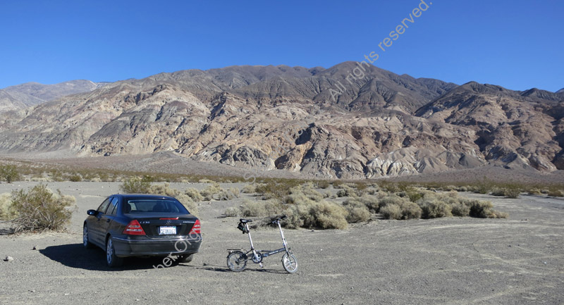
After my acclimatization and scouting hike, I cached a folding bicycle in the trees and drove down through Ballarat to Chris Wicht Camp where the road up Surprise Canyon now ends (see trailhead page). Jeeps used to winch themselves through the slot canyon above here in the early 80s, but Mother Nature and Big Brother together put an end to that with a flood and some stakes. It was pleasant to camp next to a running stream in the desert, nice that it stayed above freezing, and surprising to find that almost everyone had cancelled off the trip. This road was at the upper limit for passenger cars near the top, and I wished out loud that I had gotten a ride up instead of driving.
Friday, Jan 13
The three of us (Matt Hengst and Jack Kieffer) got a leisurely start the next morning. Jack was nice enough to shuttle me 4 miles down the hill in the morning, so I could easily reach my car with the bike later. There are lots of collapsed mine shafts and prospects to stick your head in along the canyon, but the main feature is how overgrown it has become. There are thorn bushes (I now have a manly scar on my cheek) and stickers (Matt was being re-stuck for the rest of the day) and slippery slopes (Jack danced down one slope like Neo in a Matrix clip), not to mention water running down the trail with tree branches interlaced "overhead" at chest level. There were plenty of stream crossings but only one place we had to turn back at a dead end because we missed a fork.
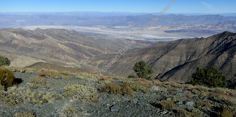
We got to Sourdough Canyon (a left turn at waypoint SOURCJ, just before Panamint City) in less than 6 hours, leaving plenty of time to search for Hanta Virus in the ruined cabins. The "surprise" of this canyon is how wide open and forested it is after the narrow slot canyon section (above 5500'). We met some hikers coming down who clued us in about the nearby accommodations: Sourdough Canyon features "The Castle" with running water and shade trees, while Panamint City features "The Hilton" which is more spacious and has more modern fixtures. These two cabins have been mostly sealed against rats by repeat-visit volunteers, the rest have piles of pellets everywhere. People sleep in them, as evidenced by sleeping bags and tarps, but I wouldn't risk it.
The Castle, in Sourdough Canyon
A nice foot path connects Sourdough to Panamint without going back down to the road fork. We poked into several cabins before climbing up to the Panamint Mine with it's tall (crumbling) brick smelter chimney and modern steel-frame buildings. The mine shaft is short and straight, which we thought might mean they filled in all the branches. Back to The Castle (waypoint CASTLE) for dinner and camp, we ate on the patio by the wood-fired bathtub and turned in early.
Saturday, Jan 14
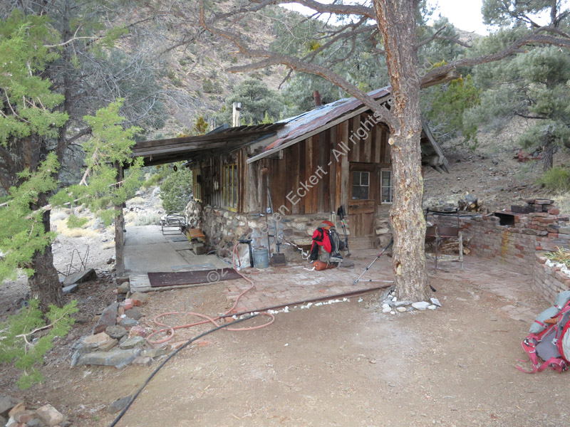
Mine Surfing in Wyoming
We left just pre-dawn, heading up to the Wyoming Mine for some deeper exploring. I weakly lobbied to get the peaks and save the mines exploring for later, but I'm glad Matt stuck to his plan. We explored two shafts, one of which involved a brisk 10-minute walk back out. The upper mine (waypoint WYOMHI) had a suitably dangerous entrance with suitably creepy bats and functional rail cars. We foolishly walked under ancient beams and pushed each other in the carts, but we did NOT descend the rickety ladder which had no visible bottom nor did we ascend a cable up what looked like a natural fissure in the rock. nor did we light a campfire at the end of the shaft as someone else had. A good time was had by all, but exiting into the colder outside air was eventually required.
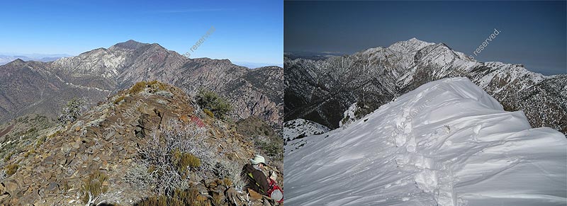
The mine road ends abruptly, and a short steep scramble put us on the ridge between Marvel and Magazine Canyons (waypoint WYORID). This ridge leads almost directly to Sentinel Peak (waypoint SENTIP), where once again the wind was fierce and the stay was short. I did manage to replicate a picture I took here two years ago, when the summit was encased in a corniced snow cap and there was no chance of digging out the register. Global warming!! (see my 2010 trip report)
Telescope behind Sentinel, as of January 2012 and February 2010
We hoped to come down via Frenchman's Canyon to make a loop out of the day and scout my ascent with a full pack the next day, after hearing that the route to Telescope from Sourdough Canyon was a "real bushwhack". Since it was well before noon we scooted down the north ridge of Sentinel with high hopes of bagging Porter and still getting back shortly after dark. The entire ridge from Sentinel to Porter is best if you stay doggedly on the ridgeline, where there is a faint use trail, except two main bumps near Sentinel.
The ridge is really easy walking. Most of it could be done on a mountain bike. But it's also longer than it looks. We crested the last bump before Porter around 130pm, well over a mile of down-and-up to from our second peak, and I did some mental calculations that convinced me to turn around. My feet were slightly sore, I was on day 2 of a 5 day trip, after dark it would be very slow going either down unfamiliar Frenchman or the ridge we ascended, and I'd already gone over Porter twice on my 2010 trip up Pleasant Canyon. I bailed. They pressed on.
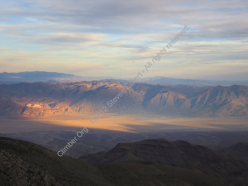
Sunset over the Amargosa River
I got back up to Sentinel at 345pm, and tried to follow the ridge to Panamint Pass. Gendarmes forced me onto the steep and somewhat loose west slope, but I got back on ridge around 9.1k and followed it to Panamint Pass (waypoint PANPAS, 8.1k). There is a use trail all the way up Frenchman Canyon, but it's vague at times and I didn't manage to stay on it after it got dark enough to need a headlamp (around 5pm). The trail is north of the drainage up high and south of the drainage below 7k, but walking in the dry streambed works OK when it's dark.
The one worrying part of the day was when I heard something snarling at me in the streambed well after dark. Two years ago I took a picture of a large paw print, almost as wide as my size 14 boot, that was not canine. This year we met someone who said they definitely saw a mountain lion in a side canyon. Hmmm. I assured whatever was out there that I was just passing through, and left without seeing so much as glowing eyes. Maybe it was a burro.
The old road comes out into Panamint between the large stone building and the steel frame shed (waypoint PANMIN), and I followed the footpath back to The Castle just in time for a civilized 6pm dinner. 12 hours, no sign of the others. I set my headlamp to flash and scanned the ridge we had climbed from time to time, finally getting a response around 10pm. Matt and Jack had several more miles to walk, and they got back to camp around 1130pm in good spirits but both limping. We stayed up to almost 1am while they had dinner and the rats scuttled around the tin roof of the cabin.
Sunday, Jan 15
It warmed up! We were much higher than the cars, but the temps were still in the high 30s overnight. I got up late, leaving camp at 8am and making my way back up Frenchman's Canyon with a full pack. Things are different going up, and different in daylight. The road crosses the streambed (just above waypoint PANMIN) and goes to Thompson Camp, quickly switching into the wrong drainage. Where the road crosses the streambed there is a mound of dirt obscuring the road on the south side of the drainage. At a jumble of very large boulders (waypoint FRCYN1), the road leaves streambed and climbs a little onto north side. Above here the road is well defined and sometimes over 100' from stream. It is overgrown in places (like waypoint FRCYN2) but you can pick it up again soon if you look. I missed it coming down because there are ducks everywhere, including the wrong places.
At about 7.1k (waypoint FRCYN3) the road gives way to a single track trail (such as it is) which goes directly up the drainage for a while and eventually stays on the left (north) side of the canyon. On the ridge at about 8.6k (waypoint PPCLF1) there were some cliffs which forced me to angle up and left (northwest) under granite faces. This is where the good footing ENDS! There is much tough brush to crash through (waypoint PPCLF2), relieved only by a field of huge boulders that avoids bush-whacking but is tedious slow climbing with a pack.
It took 5 hours to get from camp at 6.4k to the ridge at 9.5k (waypoint PPCLF3), where the trees were much less dense. The boulder field I climbed seems to define the transition from solid clothes-ripping trees to a boulder-and-tree mix on the ridge higher. No soil. The ridge is just boulders. Very slow going! The ranger I met on Wildrose mentioned a search and rescue in this area recently, where someone cliffed out going the other way. I've included these three PPCLF waypoints because when going downhill there would be no way to see and choose an efficient route.
The boulders finally eased off a bit after Point 9430, becoming simply talus as the wind gathered speed. Powerful gusts meant I had to stay on the east side of the ridge to avoid being knocked down. I should have stopped sooner, where there were some flat spots on the leeward side, but I ended up camping on the ridge near Point 9570, tying a silnyl tarp and trekking poles to a large bush to form a windbreak behind which I could at least keep my stove from being blown over while I melted meager patches of snow.
Windbreak on the ridge
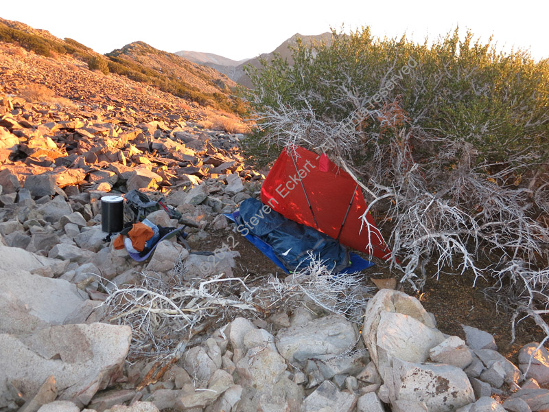
Lenticular clouds formed overhead as dusk faded to dark, the temperature dropped quickly, and the barometer fell the equivalent of 300 feet. Oops. On a ridge as a storm was blowing in? At least I was cozy behind my windbreak in a bivy bag with a zero degree sleeping bag. It was in the high teens with roaring (30 mph) wind all night. The wind got stronger after midnight and then mysteriously switched off at 8am, just as I walked away from camp.
Monday, Jan 16
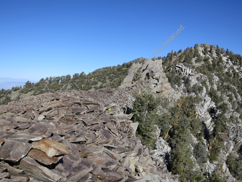
I kept thinking the ridge would be easy, like the trail side of Telescope or the traverse from Sentinel to Porter. Nope. Little cliffs and big boulders abound on the ridge, with brush on both sides to punish you for not climbing the gendarmes! Each bump seems to have a different sort of rock, but strangely none of them have worn down into soil. After a single-contour-line bump forced me down on the west side of the ridge, Point 10460 was about the first place I got to walk on dirt, and the first place with big trees. It didn't last for long, with more cliffs and steep talus between there and the final saddle.
Each bump had a different kind of rock, none of it friendly
I reached Telescope Peak at 1pm, and having spent 5 hrs to climb less than 3 miles to summit was a serious downer. It had taken me a day and a half to go roughly 7 miles! On the other hand, it was early enough to tromp all the way down the trail to the campground before dark. On the way down, I met 2 guys wearing plastic climbing boots, carrying ropes and ice racks, and actually wearing their climbing harnesses while walking on a dry dirt trail. They thought they'd get to practice snow climbing. Not this year!
I stopped at 230pm to melt drinking water from a snowdrift near the low point between Bennett and Telescope, then motored back to Thorndike by 5pm without needing a headlamp. It didn't seem cold at first, but the water I had cached with my bike was almost completely frozen and around 8pm a cold breeze started blowing down the canyon. There was lots of frost overnight, and it was only 5 deg in the morning, 20 degrees colder in the same campsite than a few nights earlier.
Tuesday, Jan 17
I coasted out of camp at 8am, bundled in fleece, down, goretex, face mask, bicycle helmet, and climbing boots (single digit temps were far too cold for my lighter shoes), all on a folding bike with 16" tires. The upper (dirt) road was so steep I had to hold my speed almost to a walking pace or the rims would overheat from braking. Once past the Charcoal Kilns and onto pavement I could have gone faster except that little bike isn't stable above 20-30mph. Sigh. Still, I made a few people smile by whizzing down a huge hill in the middle of nowhere on a toy bicycle!
How do to a loop trip in Death Valley without using a 4WD or car shuttle
It took almost 2 hours to coast 6000 feet and 18 miles down Hwy 178 to Panamint Valley Road, during which I pedaled only once for a few seconds. The last 5 miles I just sat up straight and let wind resistance slow me down. 30mph was cold with temps still only in the 20s, and scary fast on those tiny tires, but at least the rims were no longer hot! It was another 9 miles on pavement to the Ballarat turnoff, then another 6 miles of dirt road to my car. I got there before noon, very happy to be done bouncing on gravel. The little Dahon folding bike did its job without complaints (or flat tires). I celebrated by letting the Mercedes run free over Darwin Plateau...
Climbing Waypoints - see the
trailhead page
for driving/parking waypoints
![]() Download the Waypoint+ data below as a GPX file for your GPS.
Download the Waypoint+ data below as a GPX file for your GPS.
Datum,North America 1983,GRS 80,0,-1.6E-7,0,0,0
RouteName,1 ,SURPRISE CANYON
RoutePoint,D,BALJCT, 36.0336400270,-117.2815999985,01/30/2010,19:15:39,TURNOFF TO BALLARAT
RoutePoint,D,BALTRN, 36.0320770741,-117.2454816103,01/30/2010,19:35:53,
RoutePoint,D,BALRAT, 36.0476940870,-117.2240554094,01/30/2010,19:15:17,BALLARAT RD JCT WINGATE RD
RoutePoint,D,SCTURN, 36.0749647617,-117.2210577726,01/30/2010,19:14:59,SURPRISE CYN TURNOFF
RoutePoint,D,SCPARK, 36.0776499510,-117.2132999897,01/23/2012,16:42:29,SURPRISE CYN PARKING
RoutePoint,D,SUR2WD, 36.1096600294,-117.1840100288,01/06/2007,17:33:04,PASSENGER CAR TH 2300
RoutePoint,D,CWCAMP, 36.1125999689,-117.1758099794,01/30/2010,19:19:23,CHRIS WICHT CAMP 2WD TH 2600
RoutePoint,D,SOURCJ, 36.1168800592,-117.1003199816,01/08/2012,20:00:57,SOURDOUGH CYN JCT 6100
RoutePoint,D,PANMIN, 36.1180700064,-117.0947599411,01/30/2010,19:17:12,UPPER PANAMINT TO FRENCHMAN CYN
RouteName,2 ,SENTINEL TRAVERSE
RoutePoint,D,PANMIN, 36.1180700064,-117.0947599411,01/30/2010,19:17:12,UPPER PANAMINT TO FRENCHMAN CYN
RoutePoint,D,MAGCYN, 36.1149704456,-117.0910606384,01/30/2010,20:15:05,MAGAZINE CANYON
RoutePoint,D,WYOMLO, 36.1115499735,-117.0963599682,01/06/2007,17:33:04,WYOMING MINE SHAFT
RoutePoint,D,WYOMHI, 36.1100100279,-117.0965000391,01/30/2010,20:15:17,WYOMING MINE SHAFT
RoutePoint,D,WYORID, 36.1104799509,-117.0975199938,01/06/2007,17:33:04,RIDGE TO SENTINEL
RoutePoint,D,SENTNW, 36.1033650637,-117.0819704533,01/24/2012,03:02:00,NORTHWEST RIDGE SENTINEL
RoutePoint,D,SENTOW, 36.0946295261,-117.0771543980,01/06/2007,17:33:04,WHITE ROCK TOWERS
RoutePoint,D,SENSAD, 36.0932904482,-117.0702991486,03/24/2010,19:11:26,SADDLE S OF SENTINEL
RoutePoint,D,PT8803, 36.0739599466,-117.0603599548,01/30/2010,19:58:54,
RoutePoint,D,PORSAD, 36.0581803322,-117.0569877625,01/30/2010,19:58:34,SADDLE N OF PORTER
RoutePoint,D,PORTEP, 36.0499000549,-117.0564399958,01/26/2008,10:29:40,2_9 PORTER PK 9101
RouteName,3 ,FRENCHMANS CYNS
RoutePoint,D,PANMIN, 36.1180700064,-117.0947599411,01/30/2010,19:17:12,UPPER PANAMINT TO FRENCHMAN CYN
RoutePoint,D,FRCYN1, 36.1185628176,-117.0865366459,01/06/2007,17:33:04,HUGE BOULDERS
RoutePoint,D,FRCYN2, 36.1165767908,-117.0819401741,01/06/2007,17:33:04,ROAD COVERED IN BRUSH
RoutePoint,D,FRCYN3, 36.1144399643,-117.0780099630,01/06/2007,17:33:04,
RoutePoint,D,PANPAS, 36.1069999933,-117.0702999830,01/30/2010,20:07:52,PANAMINT PASS 8100
RouteName,4 ,TELESCOPE TRAVERSE
RoutePoint,D,PANPAS, 36.1069999933,-117.0702999830,01/30/2010,20:07:52,PANAMINT PASS 8100
RoutePoint,D,PPCLF1, 36.1121196747,-117.0666037798,01/06/2007,17:33:04,CLIFFS NEAR PANAMINT PASS 8600
RoutePoint,D,PPCLF2, 36.1133500338,-117.0667500496,01/06/2007,17:33:04,BOULDERS NEAR PANAMINT PASS 8700
RoutePoint,D,PPCLF3, 36.1151399612,-117.0637300014,01/24/2012,05:09:47,CLIFF BYPASS RIDGE AT 9200
RoutePoint,D,PT9430, 36.1202700138,-117.0662399530,01/08/2012,19:59:51,PT 9430
RoutePoint,D,PT9570, 36.1340800524,-117.0707299709,01/08/2012,19:59:31,PT 9570
RoutePoint,D,P10460, 36.1502699852,-117.0804100037,01/08/2012,19:59:05,PT 10460
RoutePoint,D,TELESP, 36.1698900461,-117.0891699791,01/26/2008,10:29:40,2_7 TELESCOPE PK 11048
RoutePoint,D,BENETP, 36.2064399719,-117.0929000378,01/08/2012,19:56:29,BENNETT PK 9980
RoutePoint,D,ROGERP, 36.2181472778,-117.0856620073,01/08/2012,19:56:59,ROGERS PK 10000
RoutePoint,D,MAHOGF, 36.2300797701,-117.0683296919,01/08/2012,19:55:04,MAHOGANY FLAT 8100
RoutePoint,D,WILDP1, 36.2565392256,-117.0723011494,01/10/2012,21:49:59,
RoutePoint,D,WILDP2, 36.2594717741,-117.0608705282,01/10/2012,21:50:46,
RoutePoint,D,PT8284, 36.2706887722,-117.0638262033,01/10/2012,21:50:28,PT 8284
RoutePoint,D,WILDPK, 36.2754541636,-117.0788156986,01/10/2012,21:49:34,WILDROSE PK 9064