See the trailhead page for driving directions and waypoints all the way to the summit. The 4WD trailhead is 5.2 miles from the freeway, at 2500' (waypoint ORO4WD) where wilderness stakes and a turnaround loop mark the current end of the road. Most of the group camped at that turnaround, which has plenty of room for parking but only a few tent sites.
Starting before 7am, we walked up the now-closed road on the east bank of a wash. The road crosses over a shoulder (waypoint OROC03) and sidehills down a bit. We left the road at waypoint OROC04, where it crosses a small dip and heads southeast. Minor route-finding is required here to go southwest to the wash, but not DIRECTLY to the wash, working through some steep gullies. OROC06 is where we entered the wash, just above a waterfall.
We followed the wash south and up, scrambling over two class 2-3 waterfalls. The footing isn't bad and the Cats Claw Acacia is avoidable but there's nothing memorable about this canyon. I think the DPS Guide wants you to take the right fork of the wash, but we went straight up onto a ridge (waypoint OROC08) from the end of the canyon rather than angling right toward a saddle for lower angle slopes. The ridgeline took us over a false summit (waypoint OROC09) where we were finally sure we could see the peak. It is possible to bypass the false summit (waypoint OROC09) with a use trail on the west side, but it only saves you about 30' of gain and the footing is good everywhere.
New Kids on the Block (Left: Stella and Steve. Right: Gabe, Abraham and David, Viviane and Steve)
Photos by Asher Waxman
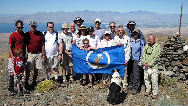
We reached the 3815' summit of Orocopia (waypoint OROCOM) around 10am, a little over 3 hours from the car. A nice breeze dispelled our fears of broiling on such a low elevation peak on the hot end of May, and we broke out the cookies and champagne to celebrate my list finish. There's a nice view of the Salton Sea from here, but in terms of peakbagging Orocopia was sort of anticlimactic compared to Dubois (13.6k) a few weeks earlier.
The return to the trailhead was uneventful, except the large desert tortoise we saw, following which we had a happy-hour-style lunch. Unusual to see a bunch of climbers sitting in lawn chairs holding umbrellas in one hand and champagne in the other, but given the rising temperatures no one wanted to hang out all afternoon waiting for the cooler evening temperatures.
"Thank You" to everyone who came, and to everyone else who contributed to my peakbagging experiences. Especially to Dan and Asher, the leaders, who demonstrated their generosity (if not their wisdom) by agreeing to give up their holiday weekend and lead a trip that could have been really hot. Even on this little bump I learned something: The best way from Joshua Tree to Bakersfield is through Apple Valley, which totally avoids the whole I-10 nightmare. Thanks for the tip!
| Steve making sure he actually steps on the high point. | Our Climbing Route. |
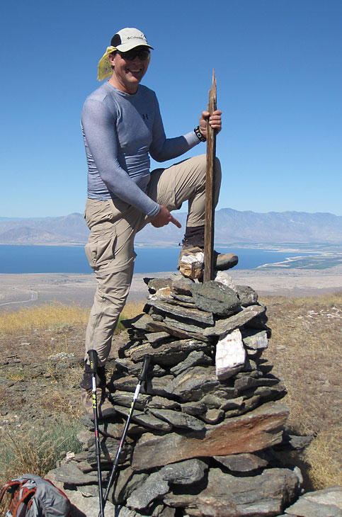 Photo by Dan Richter. | 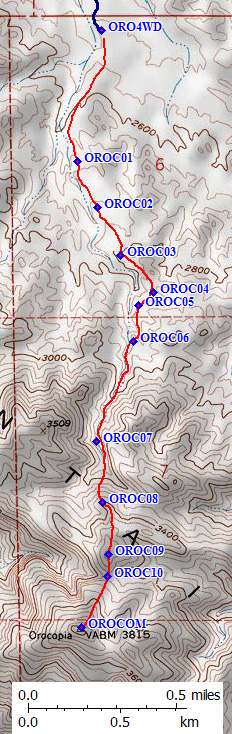
|
I've already done the "why I climb" story
(for my SPS List Finish on Kern Peak) and you know you're getting old when your attitudes don't change for a decade. The best reason to climb from a list is to explore (e.g. to make sure you don't get stuck doing the same thing over and over). The worst reason to climb from a list is to check off the peaks, rushing up and down without stopping to smell the Saguaros.
But seriously, the point of saving this spectacular (read "easy") bump for last was
to allow old and new friends and family to join me.
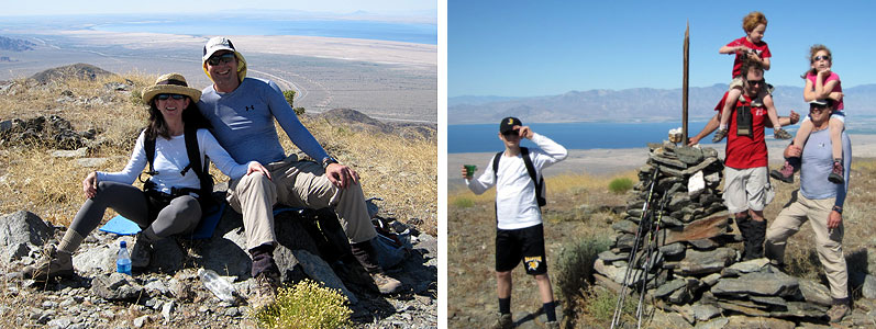
The youngest climber was Abraham, age 4:
he wasn't yet born when I last climbed with his father David.
The oldest climber was Warren, who stopped counting at 80:
he encouraged me to start leading trips with the Loma Prieta Chapter almost 20
years ago when my knees were so bad
that a 5 mile day really challenged me. Warren also got me started on continental
high points like Elbrus and Aconcagua, and he was at my
SPS List Finish
so it was a real treat to have him at the top again. It's a pity Dale Van Dalsem
couldn't be here, since he was the one who convinced me to go through the
LTC/ALTC training with the Angeles Chapter in the 80s. Stella and the kids
(age 9 and 13) made this their 3rd DPS summit ... meaning I guess I'll
have to do the list at least once more if they decide to get serious!
Each generation follows in the footsteps of those who teach them.
I can't talk about DPS peaks without mentioning my buddy and climbing partner
Daryn Dodge. I couldn't get him on this trip, but his interest in "doing the list"
and his willingness to scratch up his Jeep are the only reasons I seriously
took on the challenge of finishing. It's hard to find people willing and able
to travel for the peaks out of CA, especially when you live in Northern CA
where people only ski in the winter, and it's even harder to find people who
put in the effort to make every trip work even when things don't work perfectly.
We did 37 list peaks together in just two seasons, including most of
the technically difficult peaks, plus other summer trips both in and out of CA.
This winter, since I ended up mostly climbing alone, I had the schedule flexibility
to drive to the mountains DURING a storm, to climb as soon as it cleared, and to drive
home in the NEXT storm. This produced some memorable trips, like sloshing through standing mud and running water on the roads around Chuckwalla, then sitting out an
entire day of heavy rain and a flash flood at Granite Pass (I knew it was coming
but wanted to experience it), then shoveling dirt into the freshly eroded washes
so I could drive out.
Sometimes I failed to find registers buried in snow, but some peaks on the
list are more interesting as snow climbs. Backpacking in the desert works when
snow can be melted for water.
Porter, Sentinel, and Needle
as a 5-day backpack from a passenger car? Yep. A one-way traverse of the
Inyo Range? Sure. Snowshoes required for peaks
in Death Valley? Definitely. More than once! Getting away from the car-camp
saturday-party standard was nice, and while sometimes the silence of climbing solo
got old I also got to hear and see wildlife that would have hidden from a group.
People always want to know what peaks I consider to be the best, the worst, the hardest,
the prettiest...
Really having to think hard might be the best part of doing desert peaks.
Almost every DPS trailhead is an adventure unless you're with a group of people
who've been there before, and neither the driving nor the climbing details
in the DPS Guide are always right. I had the extra constraint of trying to
do as many peaks as possible from a passenger car road. Tree-huggers unite!
Leave that SUV at home and carpool in a higher-mileage car! (Here, let me
help you with those Joshua Tree spikes. I didn't mean to LITERALLY hug a tree.)
I learned I should prepare by reading the guide AND old trip reports,
but only use them as suggestions when I looked at the map to decide what
made sense to me. As RJ Secor told me in Cloud Canyon, a GPS can tell you
where you are but it is not capable of navigation (which he defined as
finding a safe and efficient route from point to point). A GPS frees you
to THINK about navigation, but used properly it doesn't damage your ABILITY
to navigate. Strangely, many who don't like the whole concept of a GPS and
make fun of those who carry one tend to ask for directions when the clouds
drop and there are no reference points, or when the leader has gone the
wrong way and the group needs to get back on track quickly.
I've collected waypoints from trailheads for most of the peaks on the list, and
am building trailhead pages
as I have time. Not to replace the DPS Guide, but to add a new resource that
backs up the Guide. Please help me improve and keep these pages up to date by
sending additions and corrections.
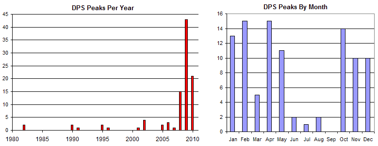
I'd like to end ("finally" they all sigh) with a couple of charts
("spreadsheets are to engineers like bottles are to alcoholics" they all scream).
Daryn did something like this for his SPS List Finish, and it made me think
about Consistency vs. The Big Push. The 5-year oscillation amused me when
I saw it on the chart.
See you in the mountains, and be sure to let me know if you want company mid-week!
List Finisher Essay
Everyone who finishes one of these lists is expected to have something profound to say.
I say "Open that other bottle of champagne!"
(which often depends on the weather, the route, or in some cases the group)
Dumbest peak to have on the list? Navajo.
Peaks you can drive to the top of? Navajo.
But oh my god, there are some sights to see around there if you just take a few
extra days to explore
Muley Point, Betatakin, Monument Valley, Goosnecks, Natural Bridges, Canyon de Chelly, etc.