Sandy Point is class 1 except for a few short rises on the north ridge. The hardest part of this climb is finding the
trailhead
and/or the entrance to the drainage that leads you to the north ridge. On the other hand, I demonstrated on my way down that it's not that important to find the right drainage!
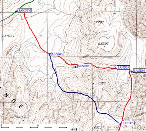
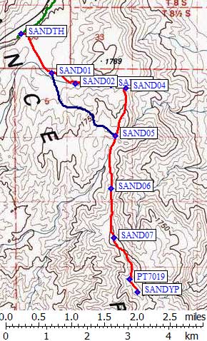
From the wide spot on Death Valley Road (waypoint SANDTH), walk east between the bump and the base of Point 5165 then turn southeast across a wide plain toward waypoint SAND01. If you have a GPS, this is a no-brainer. If not, even a cheap compass will do. Large groups should probably spread out here, to avoid tramping a path into the crusty (cryptobiotic?) soil.
The DPS route takes you east up a drainage to the ridge (wayoint SAND04) at about 5500 feet. Turn south and walk to the peak. There will be a couple of steep spots, which you can easily bypass on the left, and you'll have good cell phone reception along the whole ridge so you can check your messages while strolling to the top.
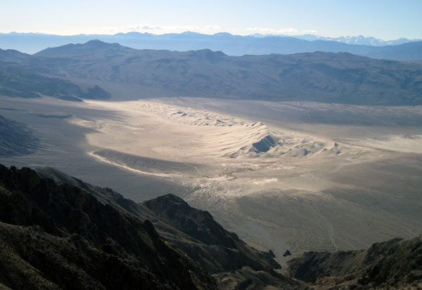
OK, so I'm a bit "down" on this peak. But it does have a really swell view of the Eureka Dunes! Let's just say "it's suitable for first-timers" and leave it at that.
On the way down I wanted to see if I could shave off some mileage and/or make the climb more interesting. I skirted around Point 6277 around 6000' elevation (the blue line from waypoint SAND05 to SAND01) and dropped very steeply into the drainage south of the climbing route. It works fine, but probably doesn't save any time since the footing is worse on the steep part.
Sandy Point - picture of Eureka Dunes from the summit
Sandy Point static maps - see also waypoints and interactive map
|
|
The Last Chance
trailhead
needs high clearance but not 4WD. Even in a regular passenger car
you can get close enough to make the peak a reasonable dayhike.
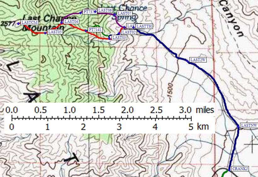
Park below mine, at waypoint LAST2WD or LASTTH depending on your vehicle.
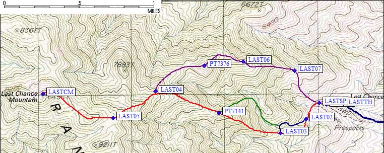
Walk into the narrow canyon and peer down the open mine shafts (one at an angle and one vertical). At LAST01 there is a junction going up to the left, but stay in the canyon. At LASTSP you'll find the actual Last Chance Spring, where water was flowing even in December of a dry year. Part of it is fenced, but the number of animal tracks calls the water quality into question.
Go left at first canyon divide above spring, then right at the second divide (LAST02) if you want to do the canyon scramble. From the same waypoint you can also go up the ridge between these two divides. I stayed in the canyon and enjoyed the mini-waterfalls which are class 2-3. Actually, I stayed in the canyon too long! Instead of following the blue line, I went up the purple line. It works, but the red line would probably be better since the approach to Point 7141 (waypoint PT7141) is less steep from the southeast.
I didn't walk the ridge between LAST03 and PT7141, but I think that part of the route would be easier and it's how the DPS guide directs you. I came down an entirely different route, so if you're not locked into DPS routes please keep reading. By Point 7141 you should be on a use trail. It's not trivial to follow, but it's worth finding again when you lose it. You'll avoid bumps on the ridge and brush on the sides.
Even with scouting a new route and breaks every hour, plus walking from the 2WD trailhead, it was only 3.5 hours to the top. The wind was really kicking up but there was shelter behind some low junipers near the summit. The Sierra Nevada was already shrouded in cotton candy as the approaching storm blew in. The desert east of me had a monolithic dust cloud sweeping across it. I decided it was time to go!
On the way down, I decided to try avoiding Point 7141. I left the climbing route at waypoint LAST04, turning NE toward Point 7376. Descending this ridge involved 100' of extra climbing (past waypoint PT7376) but in general had far better footing than the official route and the same or less brush on average. Once the angle eased off (around 6400', waypoint LAST07) I followed an easy (class 1) rib down to the springs. Be careful not to descend too far on the main ridge or you'll end up in the cliffs by the mine or below the 4WD trailhead! This ridge made a nice loop out of the trip, and I think it is the better of the two approaches.
Back to the car around 1pm, 6.5 hours including a lazy stay at the top, I managed the drive through Bakersfield and back to the Bay Area the same day... but I got rained on while doing it. This really was the last chance to do a dry peak before winter set in.
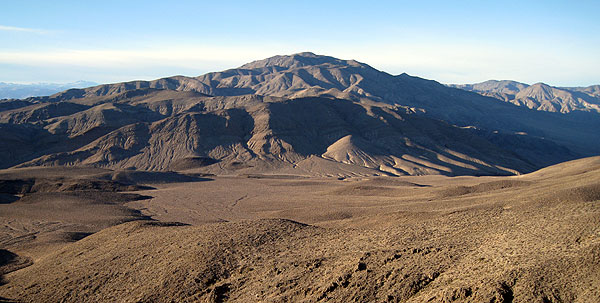
Last Chance - picture of the summit from near the base of Sandy Point
Last Chance static maps - see also waypoints and interactive map
Waypoints for Sandy and Last Chance - see above for maps
![]() Download the Waypoint+ data below as a GPX file for your GPS.
Download the Waypoint+ data below as a GPX file for your GPS.
Datum,North America 1983,GRS 80,0,-1.6E-7,0,0,0
RouteName,1 ,SandyPoint
RoutePoint,D,SANDTH, 37.2086561918,-117.6510314941,12/02/2008,19:41:49,SANDY PT TH 4900
RoutePoint,D,SAND01, 37.1999156475,-117.6426391602,01/22/2009,21:31:13,ROUTES SPLIT
RoutePoint,D,SAND02, 37.1974699497,-117.6360199451,12/02/2008,19:48:12,ENTER DRAINAGE
RoutePoint,D,SAND03, 37.1971541643,-117.6260375977,01/12/2009,00:55:07,
RoutePoint,D,SAND04, 37.1965399981,-117.6218899488,12/02/2008,19:48:30,ON RIDGE
RoutePoint,D,SAND05, 37.1859600544,-117.6247899532,12/02/2008,19:49:04,ROUTES SPLIT
RoutePoint,D,SAND06, 37.1741600037,-117.6260999441,12/02/2008,19:49:17,
RoutePoint,D,SAND07, 37.1631599665,-117.6252700090,12/02/2008,19:49:33,
RoutePoint,D,PT7019, 37.1540000439,-117.6208499670,12/02/2008,19:49:42,POINT 7019
RoutePoint,D,SANDYP, 37.1511274576,-117.6185795069,01/26/2008,10:29:40,2_2 SANDY PT 7062
RouteName,2 ,LastChance
RoutePoint,D,CRANKJ, 37.2432700396,-117.6330499649,12/02/2008,19:32:22,CRANKSHAFT JCT
RoutePoint,D,LASTNW, 37.2542699575,-117.6303000450,12/02/2008,19:36:03,NORTHWEST ON POOR ROAD
RoutePoint,D,LAST2W, 37.2709200382,-117.6462999582,12/02/2008,19:36:43,2WD LAST CHANCE TH 4800
RoutePoint,D,LASTTH, 37.2793929577,-117.6633549929,12/02/2008,19:37:27,LAST CHANCE SPRING TH 5600
RoutePoint,D,LAST01, 37.2793799639,-117.6654100418,01/12/2009,00:55:08,JCT ABOVE MINE
RoutePoint,D,LASTSP, 37.2795100212,-117.6662900448,01/12/2009,00:55:08,LAST CHANCE SPRING WATER SOURCE
RoutePoint,D,LAST02, 37.2779300213,-117.6678899527,01/12/2009,00:55:08,WASH TO RIGHT OR RIDGE TO LEFT
RoutePoint,D,LAST03, 37.2765599489,-117.6710000038,01/12/2009,00:55:08,RIDGE AND WASH JOIN NEAR HERE
RoutePoint,D,PT7141, 37.2785300016,-117.6784399748,12/02/2008,19:46:32,POINT 7141
RoutePoint,D,LAST04, 37.2806299925,-117.6861000061,01/12/2009,00:55:08,RIDGE SPLIT ON THE WAY DOWN
RoutePoint,D,LAST05, 37.2780227661,-117.6912503242,01/12/2009,00:55:08,
RoutePoint,D,LASTCM, 37.2803889513,-117.6997265816,01/26/2008,10:29:40,2_1 LAST CHANCE MTN 8456
RoutePoint,D,LAST05, 37.2780227661,-117.6912503242,01/12/2009,00:55:08,
RoutePoint,D,LAST04, 37.2806299925,-117.6861000061,01/12/2009,00:55:08,RIDGE SPLIT ON THE WAY DOWN
RoutePoint,D,PT7376, 37.2831200361,-117.6801799536,01/12/2009,00:55:08,HIGH POINT ON ALT RIDGE
RoutePoint,D,LAST06, 37.2835265398,-117.6754928827,01/12/2009,00:55:08,
RoutePoint,D,LAST07, 37.2826600075,-117.6692600250,01/12/2009,00:55:09,LEAVE RIDGE ON THE WAY DOWN
RoutePoint,D,LASTSP, 37.2795100212,-117.6662900448,01/12/2009,00:55:08,LAST CHANCE SPRING WATER SOURCE