Official PCS trip, lead by Aaron Schuman with one lone participant (me).
Back in late 1995, as a warm-up for climbing Telescope Peak from below sea level, I did a solo loop that included Lamont, Spanish, and Sawtooth. It was a long hard day that convinced me I didn't need to be in that area again... but when Aaron planned a trip there and agreed to climb Spanish from the hard side, I agreed to go. Later we found out that Eric Beck climbed Spanish Needle two days after we did (pity - we could have used the company).
(Part of my reason for going was to see if my fear near the top of Spanish had been justified, or just because I was alone and climbing wet rocks in the fog. Mere is my old trip report.
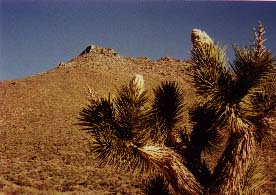
Aaron checked with some friends via email and called a ranger or two, and we decided the road to Rodecker Flat (mentioned in the Jenkins guidebook) was open far enough to give it a try. (Turn west from 395 onto Sand Canyon Road at waypoint SND395, at the sign showing Brown Road to the east.) SURPRISE! The road is well-maintained and quite drivable even for little cars, but it ends at the edge of the Owens Wilderness. Joshua Trees outnumber all other tall plants here, and you're about 3 miles short of the nice campsites at Rodecker Flat (see waypoint SNDCAR, below).
Joshua tree in bud at Rodecker Flat
A warm but windy night departed as we ditched our extra sweaters and started wondering if we had enough water bottles. It's an easy road walk to waypoint RODECK (the flats), then a bit of trail, then you either sidehill in sand or fight scrub in the drainage. Alarming tales of loose boulders with bad attitudes can't be ignored, but the main problem with the South Fork of Sand Canyon is the brush. We tried to cross the canyon around 5500' (waypoint CROSS), thinking we would sidehill up toward the peak, but soon found ourselves picking our way over rock ribs in third class crud. Your best bet is to stay in the drainage until 6000', then angle southwest in the gully that leads directly to the low point (waypoint SADDLE) between the obvious pinnacles overlooking the PCT and the true Spanish Needle. Don't go TOO FAR south, or you'll climb Point 7800 a quarter mile away (as at least one register entry moaned about).
We hit the saddle around 2pm and headed south toward the peak by kicking steps through a few patches of snow on the north face and by running the knife edge ridge in places. You know you're approaching the peak when both the east and west faces are cliffs. The Jenkins instructions may leave you thinking "the first keyhole" is near the saddle, but it's not... it's right under the 100' vertical monolith that comprises the summit. By the time you reach the keyhole, you've already had to do a bit of easy third class and you're less than 50 yards from the summit. Then the fun starts!
(By the way, looking from the saddle down toward the PCT to the southwest, I can't help thinking that climb would be easier than the traverse that Beck describes well in his trip report. Jenkins has you approach the saddle from the northeast, but someone ought to try it from the southwest to avoid the nasty traverse.)
From the boulder that creates the first keyhole, face south and tremble at the thought of climbing the sheer and featureless face looming above you. Turn to the west and wonder if that class 5 crack would be better than the Jenkins route. Then turn to the east and find his first "sapling" - well, OK, it's not a sapling anymore. It's the 10" diameter tree level with where you are. (Jenkins wrote the book a few decades ago, you see.) We had to kick steps in the snow over to that tree, wondering where the blocks he describes are. No blocks, just a set of parallel cracks that rise from the tree onto the smooth shoulder Jenkins calls a "ledge". Right. Think downsloping exposed no hand holds lichen covered (oh, and THIS time a patch of SNOW on it) granite. My fear in 95 was justified. There isn't much of a way to protect this stretch, and there are no handholds while you cross the shoulder to the boulder which Jenkins calls a gendarme (at 4' high, it's a little short cop, eh?). Now turn southwest and spot the second "sapling", actually an 8" tree, blocking the best route on the ridge. Once you're under it, the rest is easy (even the second keyhole and the 3' step-across to the summit itself). Just don't look down.
We found a plastic tube register found lying near the first keyhole, and carried it to the top where we encountered the metal ammo box with the REAL register in it. Victory! Uh, but now we gotta get back down that slab and it's almost 3pm. Fortunately the weather was perfect and the wind had died down, so we picked our way down 1000' of basket-sized rocks to the welcome sand of the north side of the south fork of sand canyon (say THAT 5 times fast, or see waypoint SAND below). We made it to the car before dark, and had a relaxing dinner with lukewarm beer and a bright sliver of moon before driving to the Chimney Peak campground (waypoint CHIMNY) for a below-freezing night.
Sunday morning we waited around for an SPSer who was supposed to join us on Sawtooth, but no one showed up. Off we went, south on the PCT from Canebrake Rd (waypoint CANPCT), to the saddle (SAWTRL) where we could see the lower reaches of Sand Canyon. Some brush along the ridge gives way to a few summit blocks (and the famous register where someone wrote "blah, blah, blah" all over a multi-page entry by Pat Ibbetson). We lazed around for a while, then tried to remember which canyon Jenkins recommends descending. Sadly, I think we took the wrong one (from waypoint SAWJCT, you should probably go due west whereas we went southwest into the gully just north of Point 6919). Our gully went as second class, but was not the beautiful draw I remember from the last trip. Getting old, or getting lost? Next time I'll go for the most sheer canyon with the highest spires guarding the entrance.
Mark Adrian adds:
Steve, you're slacking off, surprised you didn't throw Owens in too. :>>
Anyway, when Sue Holloway and I did SN a couple seasons ago, we took the approach starting from Lamont Meadow and it was a simple hike east/southeast to the PCT. But, we did encounter that hideous rib slog, what a mess that is when you try to stay too high. On return, we went painfully low to bypass the ribs. The third class was fun too but I don't recall using a rope. However, on return, we took a different route. If you view the URL map below, we took the PCT south to where in makes an abrupt bend around point 7354. Here, we found a great use trail (not shown on the map) that heads northwest to point 7475 which is also known as East Lamont and there was a very old register there with a handful of signins. Then we continued on to SPS's Lamont Peak where the trail fizzled towards the summit and a brush whack ensued. From there, we backtracked a short distance then hiked north into the flats and back to Sue's van parked near Lamont Meadow. It was a hard day and we ran low on water. Western approaches to SN seem to funnel to the saddle to its north. It seems prudent to drop below the ribs before contouring south. Otherwise, you're sure to be frustrated.
Datum,North America 1983,GRS 80,0,-1.6E-7,0,0,0
RouteName,1 ,SAWTOOTH PEAK
RoutePoint,D,9MI395, 35.8420833408,-117.8748666401,04/12/2000,21:17:47,9 MILE CYN RD AT HWY 395
RoutePoint,D,CAN9MI, 35.8692833238,-118.0131166467,04/12/2000,21:17:48,CANEBRAKE RD AT 9 MI CYN RD
RoutePoint,D,CHIMNY, 35.8388436207,-118.0431156754,04/12/2000,21:17:48,CHIMNEY PEAK CAMPGROUND
RoutePoint,D,CANPCT, 35.8357166574,-118.0439833127,04/12/2000,21:17:48,CANEBRAKE RD AT PACIFIC CREST TR
RoutePoint,D,SAWTRS, 35.8188999909,-118.0162833124,04/12/2000,21:17:49,LEAVE TRAIL FOR SHORT SAWTOOTH
RoutePoint,D,SAWTTH, 35.8230500074,-117.9986166400,04/12/2000,21:17:51,SAWTOOTH PEAK S
RoutePoint,D,SAWJCT, 35.8207666576,-118.0056666458,04/12/2000,21:17:48,CHOOSE CANYON - EASIER TO SOUTH
RoutePoint,D,SAWTRL, 35.8115333243,-118.0089666456,04/14/2000,00:48:55,LEAVE TRAIL FOR LONG SAWTOOTH
RoutePoint,D,CAN178, 35.7487333250,-118.1124666443,04/12/2000,21:17:46,CANEBRAKE RD AT HWY 178
RouteName,2 ,SPANISH NEEDLE
RoutePoint,D,SND395, 35.7761666741,-117.8722166401,04/12/2000,21:17:47,SAND CANYON RD AT HWY 395
RoutePoint,D,SNDENT, 35.7750833408,-117.8955166401,04/12/2000,21:17:47,SAND CANYON ENTRANCE
RoutePoint,D,SNDCAR, 35.7781833408,-117.9240666400,04/12/2000,21:17:47,SAND CANYON TRAILHEAD
RoutePoint,D,SNDJCT, 35.7829666741,-117.9434833067,04/12/2000,21:17:47,SOUTH FORK SAND CANYON
RoutePoint,D,RODECK, 35.7676000075,-117.9668999733,04/12/2000,21:17:47,RODECKER FLAT CAMP
RoutePoint,D,CROSS, 35.7778333408,-117.9947833066,04/12/2000,21:17:47,BAD CHOICE TO CROSS STREAM HERE
RoutePoint,D,CLIFF, 35.7759000075,-117.9967833066,04/12/2000,21:17:47,HAD TO CROSS BTWN GULLIES
RoutePoint,D,GULLY, 35.7757499914,-118.0009166450,04/12/2000,21:17:48,STAY IN GULLY NORTH OF HERE
RoutePoint,D,SADDLE, 35.7739333247,-118.0032333116,04/12/2000,21:17:48,SHOULD HIT RIDGE SE FROM HERE
RoutePoint,D,SPANSH, 35.7713833247,-118.0013833116,04/12/2000,21:17:51,SPANISH NEEDLE
RoutePoint,D,XCJCT, 35.7770999913,-118.0011833117,04/12/2000,21:17:48,BEST APPROACH FROM EAST OR WEST
RoutePoint,D,SAND, 35.7796666741,-117.9892999733,04/12/2000,21:17:48,STAY ABOVE BRUSH ON SANDY SLOPE