We got a couple of calls from people who wanted to train for an expedition or scout some other trip in the area, even a couple of people who didn't realize how far in the peaks were, but in the end it was just Steve Eckert (leader and scribe), Erik Siering (coleader) and Eric Lesser (brave participant). I can't decide whether to be frustrated about all the cancellations or glad that people knew their limits. Both, I guess.
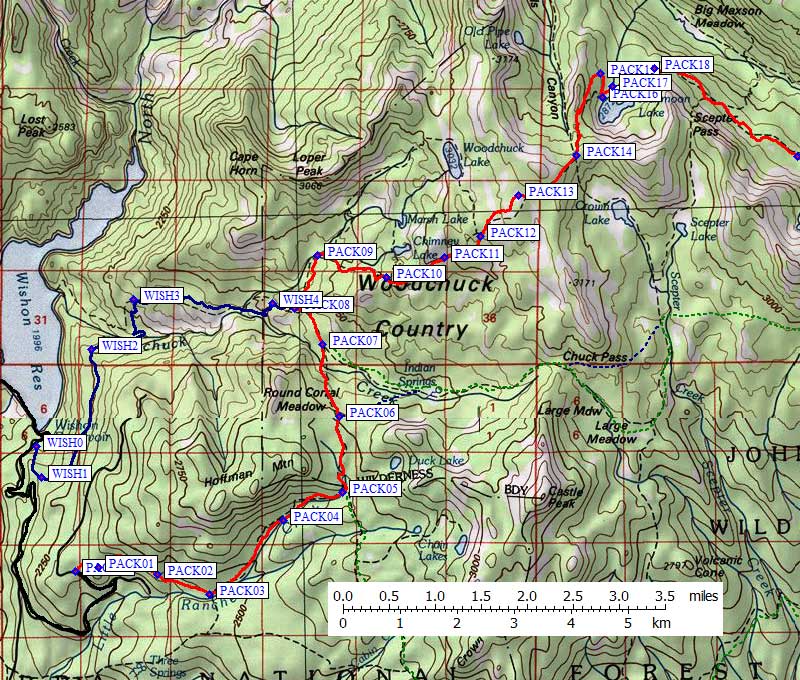
We met at the east end of the Wishon Dam spillway for the short drive to the Rancheria trailhead. (See the trailhead page for details.) We chose Rancheria (waypoint PACK00) over the Woodchuck trail (waypoint WISH0) because it's 800' higher and about the same distance (but it has a little bit of uphill on the way out). There are no trailhead quotas here, and a ranger told me on the phone that no permit was required.
The hike in was surprisingly nice, with good shade and good trail along a dry ridge to Crown Pass (PACK14). The woodchuck/rancheria junction (PACK08) is extremely vague and we marched a few minutes in the wrong direction before figuring out there had even BEEN a junction! The trail to the pass wanders a lot more than indicated on the 7.5' topo, so it's probably a bit longer than you think (the John Muir Wilderness map seems more accurate).
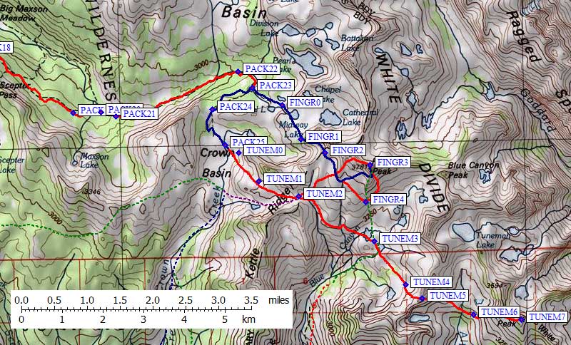
We hit our first real mosquitoes at Halfmoon Lake, and they continued all along the North Fork of the Kings River. The trail down here is hard to follow at places (between PACK17 and PACK20), but the excellent shade makes the low elevation temps bearable even in mid-summer. Most of the people we met were week-long backpackers carrying lawn chairs and/or fishing poles. Van Dalsem wrote (in 1990) that everyone who comes here wishes they had come a different way. Most people hike out a different route than they hiked in... but we actually think we got it right! Waypoints are below, and we went out the way we came in. The pack in was about 20 miles, with 4200' of gain, 12 hours.
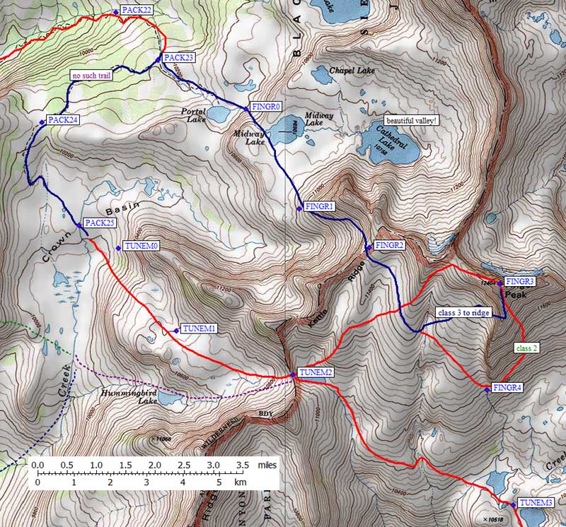
We camped two nights at the 10200' trail "junction" for Portal Lake or Crown Basin (PACK23). There is a sign, but no apparent trail to Crown Basin. The use trail to Portal Lake is well worn, and we saw a bonfire somewhere up there our first night. We were also charged by a dozen horses in Crown Basin! The horse packers use this place more than the backpackers, and unfortunately bring their high impact lifestyles such as campfires that are too big and too high to be legal, trampling the meadows, etc. Still, it's remote enough that the damage is not overwhelming.
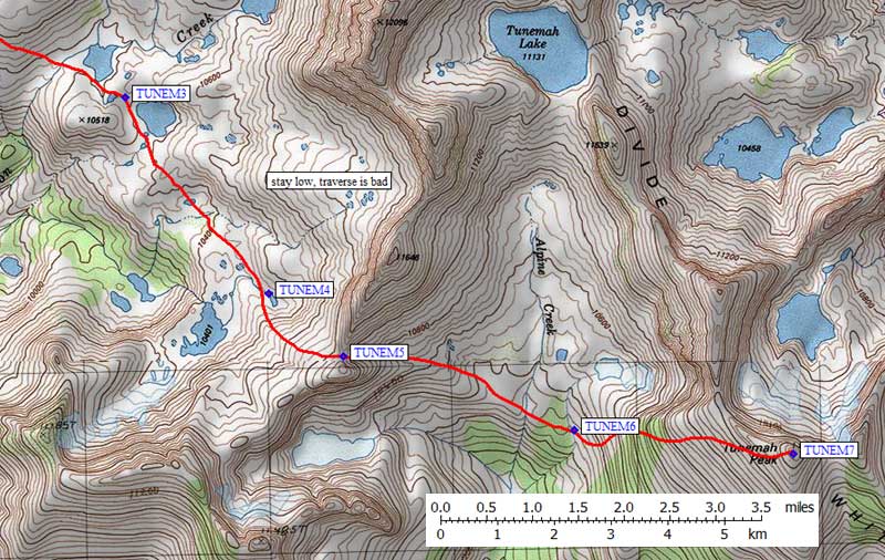
Saturday Lesser decided to rest up in camp while Siering and I headed off for Tunemah. I've heard that Tunemah is a Chinese profanity, and below is a quote purporting to explain it. If you climb this crud heap you'll probably curse the route in, but the actual climbing isn't too bad if you choose your route carefully. From Crown Basin, we hiked up easy slab/tundra terrain (TUNEM0), crossing the 11k saddle in Kettle Ridge (TUNEM2). We intended to stay high, but wound up dropping to 10.3k before climbing back up to another 11k saddle (TUNEM5), back down to 10.2k, and finally up to the peak at 11.9k. Ugh. The last grind up to the peak is best done close to the cliff (go only as far south as you need to get around) followed by a long sidehill to the summit. The ridge is boulders with pine shrubs, the sidehill is reasonably good sand between boulders.
Siering took off near the cliffs, and topped out at least 20 minutes before I did. The view is OK, but Finger is better. Still we had plenty of time so I forced him to hang around on the summit and we took some long breaks on the way back. We ran up in 5 hours and took over 6 hours to return, leaving Finger for the next day. (Our Tunemah dayhike had 3700' of gain to the peak, 5200' total for the day, 11 miles round trip.)
Sunday morning we took a side trip past Midway Lake to Cathedral Lake, intending to climb the north side of Finger's west ridge to a pass Siering found in Secor's book. Well, it turns out that's NOT where the pass is, but the valley is beautiful and I'm not sorry we visited it. There were barefoot tracks in the sand by the lakeshore, but the cirque seemed deserted. We sidehilled back around the west end of the ridge and climbed to the correct saddle at 11.6k (waypoint FINGR2). Dropping a few hundred feet, we headed for the west side of Finger's south ridge, gaining the ridge at somewhere around 12k with a few class three moves required. The return route was down the sandy SE face, crossing around the south ridge at 11k (FINGR4) and over the same 11.6k saddle to Midway, Portal, and our camp.
NOTE: I went back in 2005 and went around Cathedral to traverse the north side of Finger. See the Climb-O-Rama X trip report for pictures.
Finger is the better peak by far! The sheer north cliff tempts one to trundle, the register entries are few enough to let you know you've gotten somewhere unusual, and there's less up-and-down to get there and back (Finger was only 6 miles and 3300' of gain round trip).
Back in camp in the early afternoon, we packed up and headed down the trail. A long grind got us back to Crown Pass (with almost half the miles and 1100' of the uphill behind us) before dark. There was water and flat sand near waypoint PACK13, so we crashed and finished the 11 mile walk out in about 5 hours the next morning.
I'd like to thank Erik Siering for helping me get closer to finishing the list (as of this writing only 9 peaks remaining!), and Eric Lesser for hanging in there while we cracked the whip on the long backpacks. Hopefully the route details above and the waypoints below will take some of the mystery out of these remote peaks... add a few days to your schedule and this area could be both beatiful and relaxing.
|
Postscript, from "Place Names of the Sierra Nevada", by Peter Browning:
"There was once a 'Tunemah Pass' and a 'Tunemah Trail' - long abandoned. It was the latter that gave birth to the dreadful name, as a herd of sheep belonging to Frank Dusy and Bill Coolidge was forced down a preciptous trail into Simpson Meadow, in 1878. "Two Chinese herders - appalled by the awful chasm confronting them - worked to a point of exhaustion by their desparate efforts to force the massed and balking sheep onward - cursed the sheep, the dogs, the trail and all other related factors, in the most forcible epithets known to the celestial vocabulary. Above the bleating of the sheep and the barking of the frantic dogs, from the enveloping clouds of dust, there repeatedly and wrathfully resounded 'Teu-na-mah-ne! muck-a-hai! Yeu-nicky-shee-fut! Teu-na-mah-ne! Teu-na-mah-ne!' - a thousand times... Peck and Nye (Dusy's head packers) agreed to call the sheep plunge 'Teu-na-mah-ne'. "And what does it mean? It means something as horrible as 'You sleep with your grandmother.' It might even mean something worse than that. Consult your local authority." |
Gee, I don't know, perhaps I just violated a couple of obscenity laws!
Waypoints
![]() Download the Waypoint+ data below as a GPX file for your GPS.
Download the Waypoint+ data below as a GPX file for your GPS.
Datum,North America 1983,GRS 80,0,-1.6E-7,0,0,0
RouteName,1 ,PACK IN PREFER
RoutePoint,D,PACK00, 36.9754904509,-118.9561147690,07/28/1999,17:44:11,
RoutePoint,D,PACK01, 36.9762136936,-118.9515455961,07/28/1999,17:44:11,
RoutePoint,D,PACK02, 36.9750665426,-118.9399517775,07/28/1999,17:44:12,
RoutePoint,D,PACK03, 36.9719070196,-118.9296574593,07/28/1999,17:44:12,
RoutePoint,D,PACK04, 36.9835692644,-118.9148570299,07/28/1999,17:44:12,
RoutePoint,D,PACK05, 36.9880278111,-118.9031555653,07/28/1999,17:44:12,
RoutePoint,D,PACK06, 37.0002204180,-118.9038599730,07/28/1999,17:44:12,
RoutePoint,D,PACK07, 37.0116895437,-118.9071053267,07/28/1999,17:44:12,
RoutePoint,D,PACK08, 37.0173721313,-118.9126960039,07/28/1999,17:44:12,
RoutePoint,D,PACK09, 37.0257550478,-118.9082318544,07/28/1999,17:44:12,
RoutePoint,D,PACK10, 37.0222467184,-118.8944131136,07/28/1999,17:44:12,
RoutePoint,D,PACK11, 37.0254492760,-118.8829494715,07/28/1999,17:44:12,
RoutePoint,D,PACK12, 37.0289146900,-118.8759006262,07/28/1999,17:44:13,
RoutePoint,D,PACK13, 37.0353949070,-118.8682401180,07/28/1999,17:44:13,
RoutePoint,D,PACK14, 37.0416818857,-118.8568193913,07/28/1999,17:44:13,
RoutePoint,D,PACK15, 37.0548301935,-118.8519324064,07/28/1999,17:44:13,
RoutePoint,D,PACK16, 37.0509785414,-118.8516051769,07/28/1999,17:44:13,
RoutePoint,D,PACK17, 37.0527327061,-118.8495398760,07/28/1999,17:44:13,
RoutePoint,D,PACK18, 37.0555168390,-118.8413107395,07/28/1999,17:44:13,
RoutePoint,D,PACK19, 37.0415693521,-118.8128794432,07/28/1999,17:44:13,
RoutePoint,D,PACK20, 37.0417571068,-118.8050795794,07/28/1999,17:44:13,
RoutePoint,D,PACK21, 37.0408451557,-118.8010400534,07/28/1999,17:44:13,
RoutePoint,D,PACK22, 37.0507478714,-118.7671101093,07/28/1999,17:44:14,
RoutePoint,D,PACK23, 37.0470893383,-118.7630707026,07/28/1999,17:44:14,
RoutePoint,D,PACK24, 37.0423310995,-118.7742072344,07/28/1999,17:44:14,
RoutePoint,D,PACK25, 37.0344024897,-118.7706828117,07/28/1999,17:44:14,
RouteName,2 ,WISHON TRAIL
RoutePoint,D,WISH0, 36.9954298735,-118.9638930559,07/28/1999,17:44:11,
RoutePoint,D,WISH1, 36.9904732704,-118.9629060030,07/28/1999,17:44:11,
RoutePoint,D,WISH2, 37.0108258724,-118.9530355930,07/28/1999,17:44:11,
RoutePoint,D,WISH3, 37.0188671350,-118.9446241856,07/28/1999,17:44:11,
RoutePoint,D,WISH4, 37.0181723833,-118.9171605110,07/28/1999,17:44:11,
RouteName,3 ,FINGER PEAK
RoutePoint,D,FINGR0, 37.0433434248,-118.7546747923,07/28/1999,17:44:14,
RoutePoint,D,FINGR1, 37.0356453657,-118.7495992184,07/28/1999,17:44:14,
RoutePoint,D,FINGR2, 37.0327107906,-118.7428791523,07/28/1999,17:44:14,
RoutePoint,D,FINGR3, 37.0299071074,-118.7303586006,07/28/1999,17:44:14,
RoutePoint,D,FINGR4, 37.0217351913,-118.7316001654,07/28/1999,17:44:14,
RouteName,4 ,TUNEMAH PEAK
RoutePoint,D,TUNEM0, 37.0326349735,-118.7668930292,07/28/1999,17:44:15,
RoutePoint,D,TUNEM1, 37.0262707472,-118.7613475323,07/28/1999,17:44:15,
RoutePoint,D,TUNEM2, 37.0229169130,-118.7502098083,07/28/1999,17:44:15,
RoutePoint,D,TUNEM3, 37.0128939152,-118.7291094065,07/28/1999,17:44:15,
RoutePoint,D,TUNEM4, 37.0032521486,-118.7203211784,07/28/1999,17:44:15,
RoutePoint,D,TUNEM5, 37.0002043247,-118.7157565355,07/28/1999,17:44:15,
RoutePoint,D,TUNEM6, 36.9965444803,-118.7016174793,07/28/1999,17:44:15,
RoutePoint,D,TUNEM7, 36.9954031706,-118.6882210970,07/28/1999,17:44:15,