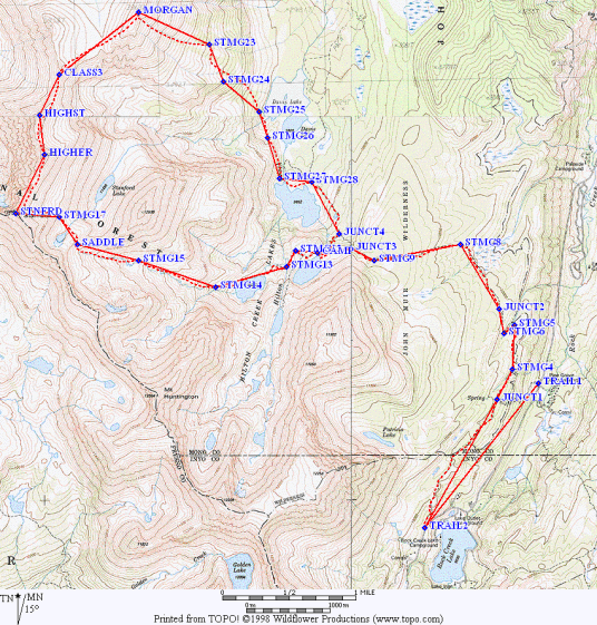
We decided to assault the east side of Stanford and Morgan, the ones near Rock Creek, as a Memorial Day ski trip. Uh, well, that was before the little girl (La Nina) dried up all the snow. It turned out we didn't need the snowshoes OR crampons we carried, and much of the route was dry. (I should note that the OTHER Morgan is just 8 miles away, and a much better ski peak for non-experts like me - my report on Morgan South in 1997 is on the web.)
Not only was the Sno Park closed (no permit required) the gate was open and the road was clear all the way to the gates just above Rock Creek Lake (at the pack station). A quarter mile below those gates (waypoint TRAIL2) is the well marked trailhead for Davis and Hilton Lakes, where the parking spaces were open but the outhouse was locked. Less well marked, but visible if you look for it, is the trail (waypoint TRAIL1) that goes from Pine Grove campground up the hill to join the flatter but longer trail we took. The junction (waypoint JUNCT1) is marked only for the lakes, and does not indicate where the eastbound trail goes (to Pine Grove).
We left late and walked slowly, and still only managed to take 4 hours getting to our campsite at the lake east of Lake 10353 (waypoint CAMP). Near the lake outlet there are campsites in abundance, and also trash. We carried out old water bottles, batteries, lollypop sticks, and a length of clothesline. It's too easy to get there, I suppose, so people don't take care of it? We considered climbing something that afternoon, but sat around in the warm sun talking instead. Early season trips are more fun if you wait for your body to adjust to altitude, and we all wanted to do the ridge traverse between the peaks the next day. It turned windy just before dinner time, and went dead calm right after we hit the sack - a coincidence?
Day Two dawned clear and mild (in the high 20s overnight), and we swarmed up the drainage west of Lake 10353 on hard snow that didn't quite require crampons. Secor's book is vague on which drainage to take, but skirt 10353 on the north and then head for the saddle above the Stanford Lake drainage (waypoint SADDLE). It was covered with snow, but looks to be nice terrain in all seasons. We ignored Secor's advice to stay west at the saddle, choosing the lower angle snow to the low point and then down a bit to the 12000' lake which drains into Stanford Lake. Perhaps the low point of the saddle is not the best place in the summer, but it was great for us. We also ignored the advice about going over a false summit, angling up to a point due east of Mt Stanford (waypoint STMG17), and then straight up the bowl to the summit (waypoint STNFRD).
Mike correctly pointed out that the named summit of Stanford was chosen because it's on the crest between east and west side drainages... the bump north of it is higher by 50 feet, and the NEXT bump is even HIGHER at about 100 feet over Stanford. The highest bump (waypoint HIGHST) has a tiny sardine can register, and is the easiest way to get to the tiny bit of third class on the traverse. Between the high point and the broad saddle southwest of Morgan is mostly second class but if you stay right on the crest you get a bit of fun third class scrambling. We're not sure, but we suspect it can be done entirely second class if you are willing to sidehill 50 to 100 feet down from the crest and hunt for easy routes.
By now it was mid afternoon and the snow was rotten mush. Snowshoes would not have helped, and the patches of snow were too small for skis to be efficient (but too large to avoid). Grunting down to the saddle SW of Morgan, we started putting on extra clothes as the clouds blocked the sun and a few snowflakes drifted by. We saw evidence of showers in the distance on every side, but so far we were dry and visibility was perfect. (But you know what's coming when someone writes that in a trip report!)
With our less-than-stunning pace, we sat on top Morgan at 4pm and worried about the clouds. There are two summit bumps, with the north one being higher. A short downclimb of the southeast chute (closest to the summit) lead us to almost 1500' of soft steep snow. My Avocet registered a descent rate of 14000 feet/hour, a new personal record (5000 is normal). Drying off, we crossed into the southern chute just below 11000' (waypoints STMG23 and STMG24). If you head too far south while still too high, you'll hit cliffs. If you follow the northern chute you'll hit cliffs. Secor says to choose carefully, but doesn't indicate which choice to make - cross around 11k, and then head straight for the western inlet to Davis Lake. The route has a lot of room, so it's not necessary to choose very carefully - just follow the southern of the two big chutes all the way to the shore of Davis Lake if you have any doubts.
There are logs which look like they used to be part of a bridge at the outlet of the upper Davis Lake (waypoint STMG27), which makes crossing the stream easy even in high water. By now it was 7pm and raining lightly, the peaks were out of sight in the clouds, and we had to tromp through the snow 500' uphill to camp. Fortunately, the wind and rain quit just before dark, but the rain drops on my bivy bag froze before they dried.
Monday was a 2.5 hour hike out and a 7 hour drive home, which was fortunately completed before the mad rush of homeward bound holiday traffic hit. We didn't start very early after a 4800' summit day that took 13-14 hours. The most dangerous part of the trip (for me) was driving home: Mike had to thread the needle between the left shoulder and a Volvo who whipped into a U-turn (without looking back) after apparently stopping on the right shoulder. Nice driving for a SUV land yacht, but I longed for my nimble CRX at the moment.
Everyone made both summits, and for the most part we enjoyed June conditions in May. Thanks to Charles Schafer for leading, and to Tim Hult, Mike McDermitt, and Bob Suzuki for making it an enjoyable trip.
Datum,North America 1983,GRS 80,0,-1.6E-7,0,0,0
RN,10 ,STANFORD MORGAN
RP,D,TRAIL1, 37.470910550,-118.7254393939,12/31/1989,00:00:00,UNSIGNED TRAIL
RP,D,TRAIL2, 37.455246449,-118.7408299092,12/31/1989,00:00:00,DAVIS LKS TRAIL
RP,D,JUNCT1, 37.469231487,-118.7310183886,12/31/1989,00:00:00,TRAILHEAD CHOICE
RP,D,STMG4 , 37.472503782,-118.7289262656,12/31/1989,00:00:00,28-MAY-99 16:29
RP,D,STMG5 , 37.477267385,-118.7286419515,12/31/1989,00:00:00,28-MAY-99 16:29
RP,D,STMG6 , 37.476350070,-118.7300688867,12/31/1989,00:00:00,28-MAY-99 16:29
RP,D,JUNCT2, 37.478989364,-118.7307608966,12/31/1989,00:00:00,UNMARKED TRAIL J
RP,D,STMG8 , 37.486070395,-118.7360341195,12/31/1989,00:00:00,28-MAY-99 16:29
RP,D,STMG9 , 37.484316231,-118.7477714662,12/31/1989,00:00:00,28-MAY-99 16:29
RP,D,JUNCT3, 37.485582233,-118.7509203795,12/31/1989,00:00:00,XC TO CAMP
RP,D,CAMP  , 37.485158444,-118.7554318551,12/31/1989,00:00:00,GOOD CAMPING
RP,D,STMG12, 37.485346199,-118.7584573869,12/31/1989,00:00:00,28-MAY-99 16:29
RP,D,STMG13, 37.483592034,-118.7596536521,12/31/1989,00:00:00,28-MAY-99 16:29
RP,D,STMG14, 37.481381894,-118.7692881469,12/31/1989,00:00:00,28-MAY-99 16:29
RP,D,STMG15, 37.484316231,-118.7797863130,12/31/1989,00:00:00,28-MAY-99 16:29
RP,D,SADDLE, 37.486070395,-118.7881118897,12/31/1989,00:00:00,LOW POINT
RP,D,STMG17, 37.489004732,-118.7905687932,12/31/1989,00:00:00,28-MAY-99 16:29
RP,D,STNFRD, 37.489390970,-118.7965125684,12/31/1989,00:00:00,STANFORD NAMED
RP,D,HIGHER, 37.495828272,-118.7925482634,12/31/1989,00:00:00,50 OVER STANFORD
RP,D,HIGHST, 37.500060798,-118.7932724599,12/31/1989,00:00:00,90 OVER STANFORD
RP,D,CLASS3, 37.504518629,-118.7905902509,12/31/1989,00:00:00,3RD CLASS PART
RP,D,MORGAN, 37.511261702,-118.7797594909,12/31/1989,00:00:00,NORTH BUMP HIGH
RP,D,STMG23, 37.507796288,-118.7701249961,12/31/1989,00:00:00,28-MAY-99 16:29
RP,D,STMG24, 37.503719331,-118.7682152633,12/31/1989,00:00:00,28-MAY-99 16:29
RP,D,STMG25, 37.500441671,-118.7633980159,12/31/1989,00:00:00,28-MAY-99 16:29
RP,D,STMG26, 37.497619987,-118.7622071151,12/31/1989,00:00:00,28-MAY-99 16:29
RP,D,STMG27, 37.493199707,-118.7606299762,12/31/1989,00:00:00,28-MAY-99 16:29
RP,D,STMG28, 37.492856384,-118.7562633399,12/31/1989,00:00:00,28-MAY-99 16:29
RP,D,JUNCT4, 37.487180830,-118.7525189761,12/31/1989,00:00:00,JCT CAMP OR CAR
Owen Maloy adds:
>We decided to assault the east side of Stanford and Morgan, the ones near
>Rock Creek, as a Memorial Day ski trip. Uh, well, that was before the little
>girl (La Nina) dried up all the snow. It turned out we didn't need the
>snowshoes OR crampons we carried, and much of the route was dry. (I should
>note that the OTHER Morgan is just 8 miles away, and a much better ski peak
>for non-experts like me - my report on Morgan South in 1997 is on the web.)
From a skier's point of view, in a good snow year Stanford (the north one) has a nice east facing bowl and valley with good corn snow, and it's pretty easy to get to and not steep. We had good corn there in '96. South Morgan, on the other hand, usually has rocks on top showing on account of the wind, even though it's north-facing. It's more of a winter bowl ski.
At Sonora Pass there was plenty of snow.
It has been snowing for four days in Mammoth, and we have 8 inches of freshies at 8300' right now (9 AM 6/4). Heard in the supermarket:
"Welcome to Juneuary!"
"I just love living where the seasons change!"
"I'm sure glad summer didn't last forever! Two days is plenty!"