We had meant to climb Cartago Peak from Horseshoe Meadows trailhead, but the extraordinary snowfall of 1998 left that road closed. So like the mountaineers of Norman Clyde's generation, we climbed all the way from the desert to the summit. Our group consisted of Steve Eckert (leader), Arun Mahajan, Dee Booth, Bob Evans, David McCracken, and co-leader and chief trip report exaggerator, Aaron Schuman.
The water that once irrigated Owens Valley and fed Owens Lake is now diverted to the swimming pools of Los Angeles. We parked alongside the L.A. aquaduct (3700') and walked through the sand and the sage brush. Stepping tall and slipping backwards on the soft surface, we painstakingly walked into a higher region of joshua trees, then gnarled cedars, and then up to pinyon pines. We crossed a band of granite boulders, challenged by the weight of our weekend backpacks, and reached the first level area (8400'). The first goodly patches of snow were here (but not even a trickle of running snowmelt); we could melt some snow on our camp stoves for drinking and cooking water. We made camp.
We set out for the summit on Saturday afternoon, but after gaining another 500 feet, we admitted how tired we were from the backpack to our camp. We returned. A strong south wind had picked up. Far below, we could see the salts of Owens Lake being whipped upward into a huge alkali storm. I had read about how the L.A. Department of Water and Power had created this particular environmental disaster by draining the lake, but I had never before seen it. I hoped there would still be paint on my car when I returned. We huddled in what meager shelter we could find, behind snags and boulders, ate and rested. Arun dined on couscous, the national dish of ancient Carthage and the co-located modern state of Tunisia. During the night the half gale roared: Our tent poles shook and our tent flies pounded like the oars and sails of Roman warships, but the sky was clear and the stars were dazzling.
Sunday at dawn we set out for the mountaintop. The merciful wind had calmed. Though we quickly came into the area with heavier snow cover, we found no place on the mountain where there weren't substantial patches of bare rock and gravel. Four of our number carried snowshoes, but never needed them to cross the shallow, hard frozen snowpack. We found other good campsites up above, including a flat, wooded (but waterless) one around 9200 feet.
Cartago Peak is not shown on any published map; it is informally named by climbers. We wondered if such an unknown destination could be worth climbing, but we were not disappointed. The complex summit and fine views more than made up for the difficulty in finding a route to an unmarked point.
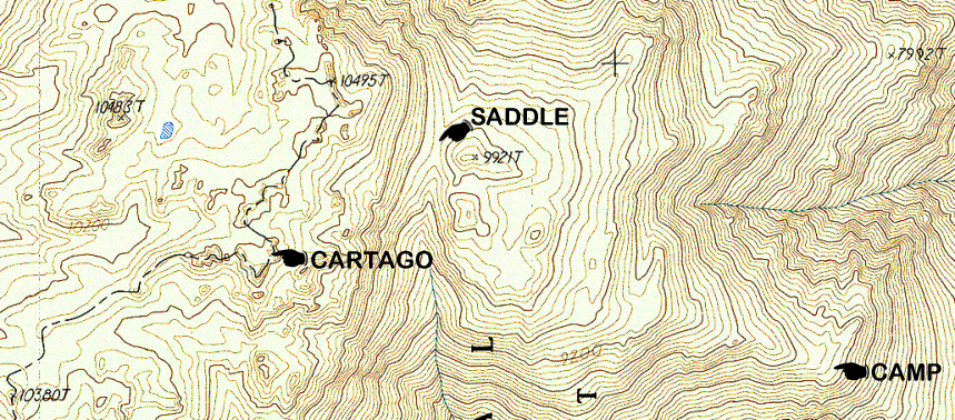
We dropped a couple hundred vertical feet to cross a small saddle, then gained the summit plateau. As our friend Owen Maloy had promised, it was "a wonderland of rocks". On a flat area of sand and snow, there were a dozen towers each rising one hundred to one hundred and fifty feet. Just looking at them, we couldn't tell at all which was the tallest summit. Owen had described it as the southernmost tower. Mark Adrian had supplied us with UTM (Universal Transverse Mercator) coordinates for the true summit, accurate to within ten meters. Steve's GPS (Global Positioning System) locked on to seven satellite signals and correctly pinpointed the 10480' peak. Getting guidance from outer space sure made the mirage of the ancient Mediterranean disappear like Caesar's ghost!
Bob remained behind on the plateau taking photos while the rest of us scrambled over the boulders to the top. There was a stunning view of the precipitous north face of Olancha Peak, especially interesting since several of us had made an easy climb up Olancha's southeast slopes last year. We also saw the snowy summits of Kern Peak, Mount Muah, Owens Peak, and Mount Langley, and across the desert to White Mountain Peak and Telescope Peak. "Delenda Est Cartago," vowed Roman Senator Cato the Elder, "Carthage must be destroyed," and memorializing the absolute Roman devastation, Arun sprinkled a small package of salt on the topmost rocks.
After returning to camp, we tried a different route to avoid the rocky band, but ended up instead in a patch of dense brush. We broke through, then plunged down the sandy east flank, past the wildflower strewn homes of roadrunner and snake, all the way to the aquaduct and the ruins of the ancient civilization we left behind. No, wait! It was back to the ruins of the modern civilization ... and really, it wasn't even ruined, just a little dusty.
Steve Eckert adds a detailed route description, waypoints and map:
(see the link below for an interactive map with all the waypoints)
We had some trouble meeting, since the writeup said to meet at the Cafe in Cartago... the Ranch House Cafe is actually in Olancha, 2 or 3 miles south of Cartago (see waypoint CAFE). We drove to the north end of Cartago and turned west on a dirt road (see waypoint 395JCT) that crosses the aqueduct via a quite drivable bridge (see waypoint BRIDGE). (Not sure why others have crawled across in a tunnel or footbridge or whatever!) We went south roughly half a mile on the aqueduct access road (see waypoint CAR) and parked off the road in a wide spot. 4WD vehicles can drive a bit further and turn west again up a short spur road that leads to a use trail (see waypoint 4WD).
The use trail peters out where the pine trees start, and it's pretty much up to you which sand you walk in. The terrain is clumps of plants in loose soil, and washes might be slightly looser than ridges. We headed more or less for the peak, angling left (south) because it looked lower angle than straight up the draw (see waypoint RIDGE). There were a few third class moves with packs before we broke through the rock band to camp at 8400' (see waypoint CAMP). We came down to the south of this band, bushwhacking a bit instead of doing 3rd class. It's possible there is an easier way slightly north, and the campsites are bigger and sandier over there (see waypoint ALTCAMP).
We followed the ridge up past some more great campsites around 9300' to the saddle between Point 9921 and the Cartago plateau. Stay to the south of 9921 but north of the other bumps, since the south drainage has very steep sides. >From the saddle, we angled up west-southwest, avoiding rock faces well above us. At waypoint TRAVRS we thought we could see the peak, but could not. Going through a minor saddle, we followed Mark Adrian's GPS coordinates to a flat sandy area ringed by crags. From here it's a 5-minute scramble to the top first on boulders under the west face of the peak and then cutting left on third class with good holds to the summit. There is no need for a rope, and we found several routes with varying exposure.
The summit is in the southeast corner of the flat sandy area, and the sandy area is distinguished by far fewer trees and a flatter surface than we had seen in other areas. Approaching from the west, your observations may vary! The summit area is the north wing of a small L-shaped ridge, at least that's how it appears from the northwest. The web version of this report has a scanned 7.5' map with pointers showing our camp, the saddle, and the peak. I've included waypoints MUAH and KERN below, picked off the map, just in case you wonder where those little bumps are when you're on top of Cartago.
See waypoints CARTAG and MACART for my GPS entry and Mark Adrian's entry. We were both sitting on the summit at the register, but the readings are about 0.1 mile apart. The government can diddle the signal by 100 meters, to prevent accurate missile targeting, and that's about 0.06 miles. It appears that Mark and I were there under different error conditions (e.g. the signal was intentionally in error one direction for him and the other direction for me), so our readings are off by more than you would expect when comparing coordinates from the TOPO! software to field observations.
NOTE: More accurate waypoints and better maps are available!
See Steve's 2003 report
for a different route, or
Daryn's 2006 report
on this route.
The best waypoints are on the
trailhead page.
![]() Download the Waypoint+ data below as a GPX file for your GPS.
Download the Waypoint+ data below as a GPX file for your GPS.
Datum,North America 1983,GRS 80,0,-1.6E-7,0,0,0
RN,1 ,OLANCH TO CARTAG
RP,D,CAFE , 36.286565066,-118.0108828191,12/31/1989,00:00:00,RANCH HOUSE
RP,D,395JCT, 36.324169637,-118.0258817319,12/31/1989,00:00:00,DIRT FROM 395
RP,D,BRIDGE, 36.330199243,-118.0301518086,12/31/1989,00:00:00,CANAL BRIDGE
RP,D,CAR , 36.323633195,-118.0353982095,12/31/1989,00:00:00,BEFORE 4WD JCT
RP,D,4WD , 36.324834824,-118.0423826817,12/31/1989,00:00:00,4WD ROAD TO TRAIL
RP,D,RIDGE , 36.320108772,-118.0701542739,12/31/1989,00:00:00,POINT ON RIDGE
RP,D,CAMP , 36.320634485,-118.0729920510,12/31/1989,00:00:00,OUR CAMP
RP,D,ALTCMP, 36.321321131,-118.0728203896,12/31/1989,00:00:00,BETTER CAMP
RP,D,SADDLE, 36.330311895,-118.0931676272,12/31/1989,00:00:00,BELOW PLATEAU
RP,D,TRAVRS , 36.328927875,-118.0977702979,12/31/1989,00:00:00,PLATEAU EDGE
RP,D,CARTAG , 36.324802638,-118.1038857345,12/31/1989,00:00:00,CARTAGO ECKERT
RP,D,MACART, 36.325011850,-118.1019277219,12/31/1989,00:00:00,CARTAGO ADRIAN
RP,D,MUAH , 36.399909855,-118.1245172862,12/31/1989,00:00:00,MUAH MTN
RP,D,KERN , 36.307636500,-118.2876224164,12/31/1989,00:00:00,KERN PEAK