People kept telling me that Warren was a slag pile, a broken down heap, and so forth. But when someone called him a scree slog with a brushy bottom, I realized we were talking about Mt Warren and not Warren Storkman (my good friend and the esteemed Chair of the Peak Climbing Section). The only reports on the PCS or SPS websites indicated an overnight climb from Lundy Canyon??? With all of the discouraging comments, I decided to solo dayhike Warren so as not to expose any of my friends to such a terrible experience.
NOTE: I returned in 2011 to climb Warren in mid-winter from the Lee Vining Ranger Station, another route I hadn't seen written up before.
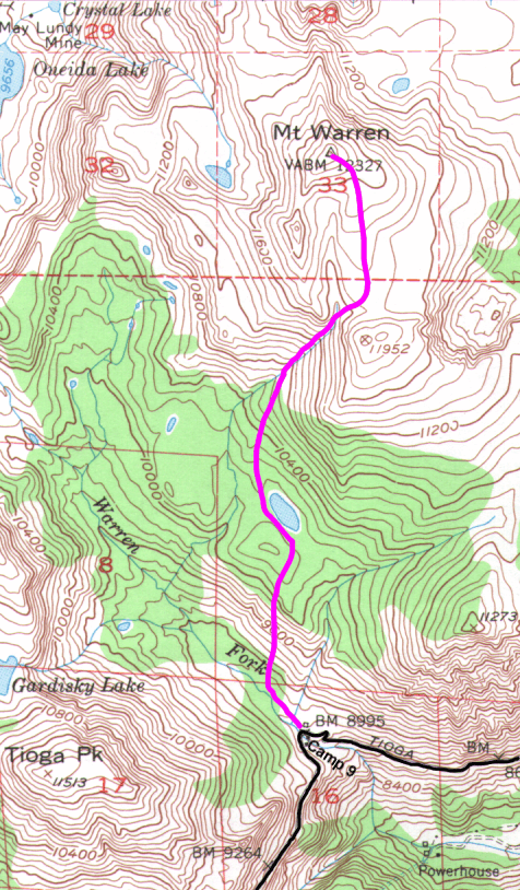
On my way home from Onion Valley I stopped off at Camp 9 (the 9000' elevation major hairpin turn between Tioga Pass and Lee Vining) to see whether the brush was as bad as had been predicted. I noticed that the usual "Camp 9" was marked "No Camping", but right across the road you can walk 2 minutes past the "road closed" sign and be in the Warren Canyon camping area with picnic tables and free numbered campsites. Why take the risk on a citation for camping illegally when you can just walk into the trees and camp in comfortable flat sites with no road noise?
There's a trail up the Warren Fork of Lee Vining Creek, but I only stayed on it for about 10 minutes. Bugs and mud motivated me to seek drier ground. Other PCS groups have gone up the canyon and looped around the west or north side of the peak, but I wanted to shave off a couple of miles. An SPS member warned me that the ridge from the trailhead was brushy, so I cut off the trail and went through a couple hundred feet of moderate brush to a low-hanging talus slope (below some minor pinnacles) that cuts through most of the brush and small trees. I angled left at the top of the talus where fairly stable footing could be found. This brought me to the south and east sides of a little bump behind which there is a good sized lake (10100') on the 15' topo. The lake is now a meadow, but the walking in that whole area is great - pine needle duff and no brush, boulders, or fallen trees to work around. A small stream not on the 15' map drains the southwest corner of the lake.
Continuing up through the trees in easy terrain, I hit the drainage between Mt Warren and Peak 11952 somewhere around the 10600' level. The 15' topo (made before I was born) shows a stream all the way to the crest, but in the 90s that stream ducks under the boulders below 10400'. It rumbles and gurgles, taunting you all the way up, but never shows itself. Imagine my surprise to find a reasonable use trail pounded into the large talus and boulders of the drainage! From 11700 to the summit (12327) is back to class 1 where the register indicates bighorn sheep can sometimes be seen.
The register also indicates that many people climb from Lundy Canyon, but I can't figure out why... it's more elevation gain, and looks like you miss the wonderful forest walking (which reminded me of Chagoopa Plateau). A small plane was doing acrobatics in Lundy, which would have really made my day had I been hiking there. There is a radio repeater on the summit, and every helicopter crew that works on it signs the register (some laughing at hikers who don't fly there), so it's not a real wilderness experience at the top. On the other hand, the view of Mono Lake is well worth the effort.
The climb took about 2.5 hours, and the return was about 1.5 hours, making this a good halfdayhike to include if you're burning a day driving from the eastern Sierra to the Bay area. (Your time may vary, depending on route finding skills and conditioning!) It could also be made into an easy overnight trip since there are an infinite number of great campsites around the "lake". Including breakfast at Schat's in Bishop, the climb, a leisurely lunch, and the drive, I got from Onion Valley to Belmont in just over 12 hours. The early talus was the only bad footing of the route, and that's only about 400' out of 3400'. So you see, Warren's not as bad as you may have heard!
PS: There is (or will be) a scanned route map with this report on the PCS website in case my route description is vague. New leaders might consider this as a place to build their confidence, since a route mistake merely lengthens the trip and can't really get you in trouble. Keep in mind that you are in the trees part of the way, and you never see the summit until the crest at 11700, at which point the antenna and solar array make it pretty obvious. Oops - too big of a hint. Sorry!