Big Meadow (Sirretta, Taylor, Rockhouse)
Revised Oct 2007 - please send updates to the webmaster
Note: If you're headed to Bartolas Country to climb the north ridge of Pilot Knob (S) (which Daryn Dodge and Steve Eckert climbed in 2007), avoiding the private land south of the peak, follow the directions below to LNGJCT and then continue south following the directions on the Pilot Knob (S) directions page.
If you're headed to Big Meadow (half-day hikes to Taylor Dome and Sirretta from here, a full day hike to Rockhouse), take the Sherman Pass road to the Big Meadow turnoff (waypoint BIGJCT), then go south past Poison Meadow (waypoint POISON) and Horse Meadow. Part of the road is dirt, but regular passenger cars can drive it without any problems (as of 2005). It's 12 miles from Sherman Pass Road to Big Meadow, mostly uphill.
The road circles Big Meadow, and you'll enter the loop at waypoint BIGMDW. There are formal campsites at the north end with horse trailers and radios everywhere or you can just walk into the trees most anywhere. There is a road that continues south to Long Meadow from the Big Meadow loop at waypoint LNGJCT, leading you to Bartolas Country and the northern approach to Pilot Knob (S). All the Big Meadow trailheads are on the eastern half of the loop, which is a left turn as you reach BIGMDW, and they're all about 7800' elevation.
For Sirretta, go about half a mile northeast from BIGMDW to waypoint SIRETH. This is a MOTORIZED VEHICLE trailhead, and you may see dirt bikes on the trail.
The next trailhead you come to is for Northern Mantern Meadow (waypoint MANTRN), and it's not the best way to get to any peaks. Keep going.
The third trailhead you see will be Southern Manter Meadow (waypoint MANTRS), and this is the one people usually use for Rockhouse... unless they're climbing it from the east via Long Valley and Rockhouse Basin. This trail takes you to the southern edge of Manter Meadow, where you can loop around to Manter Creek. There's a horse loading ramp and plenty of manure here.
The last trailhead is almost invisible, just a few yards south of the corral and loading ramp, at waypoint TAYLTH. This is the most efficient way to get to Taylor Dome, if you don't mind following a faint trail. There is a nice cross-country route which takes you directly to Manter Meadow from Taylor Dome, as detailed in this 2005 Trip Report, just in case you want to bag Rockhouse on a one-way trip to Canebrake Road or just dayhike both peaks from Big Meadow.
Useful Links:
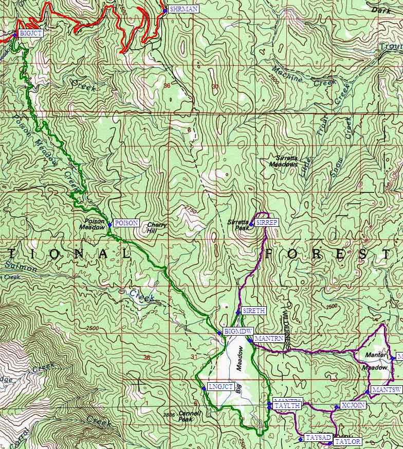
Big Meadow area map:
Go south from LNGJCT to reach Bartolas Country and the northern approach
to Pilot Knob (S).