|
|
|
We had often thought about a trip to Peru to visit Machu Picchu, the famous archaeological site. We flew to Lima and spent two days in Cuzco before taking the train down to Machu Picchu. Machu Picchu lies on a ridge formed by a U-bend in the Urubamba river, one of the tributaries of the Amazon. The site is at about 8,500' and consists of a mixture of agricultural, domestic and ceremonial areas. It is one of the few Inca sites not plundered by the Spaniards and was only rediscovered in the early 20th century. The overgrowth has been cleared, but the site is maintained mostly as it was found, with very little reconstruction or restoration necessary. |
|
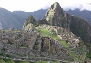
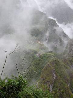
Near the end of the ridge, to the south of Machu Picchu, a spire rises nearly 1,000' above the ruins. Huayna Picchu is the sunlit peak in the upper center part of the photo above, and the central feature of the closer photo to the right. Amazingly, the Inca developed and farmed this spire, as well. Huayna Picchu translates as "Young Peak", complementing Machu Picchu, or "Old Peak." The first afternoon we spent in Machu Picchu, we watched in fascination as people made their way up Huayna Picchu. Our tour guide, Jaime, cautioned us that it was steep, difficult and dangerous. That was enough to convince me to try it the next morning. One other couple from the tour group decided to do likewise, but the remainder of the group either stayed down in Aguas Calientes or hiked north up the Inca Trail with Jaime the next morning. |
|

|
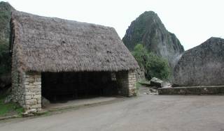
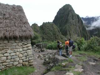
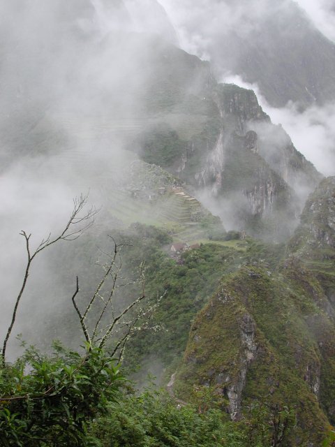
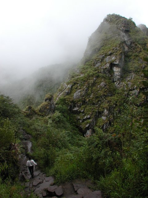
The morning arrived overcast and damp. Catching the first bus up to Machu Picchu at 6:30, I wandered up to the north end of the site briefly to take a few more photos under vastly different lighting conditions from the afternoon before. The clouds, mist and fog that drifted over the site leant an appropriately mysterious air to the scene. Temperatures were comfortably in the 60s (F) but the occasional mist and drizzle lobbied for a waterproof shell. The approach to the trailhead is visible in this photo, between the two thatch-roofed shelters in the center left, in front of the rocky ridge leading south to Huayna Picchu. |
|
The trailhead itself is through a gate in the fence in the lower center of the photo to the right. A small hut is normally occupied by a worker who requires that you sign in and out from the trail (so they can notify the next-of-kin, I suppose). The trail opens at 7:00, and when I got there about 7:10, the gate was open but there was no sign of a worker nor a sign-in book, so I left a business card stuck between two boards of the counter and headed onto the trail. About five minutes after passing through the fence, I met a British family who had started down the trail but turned around after about ten minutes in, having been spooked by the exposure along a knife-edge ridge that must be traversed between Machu Picchu and the start of the climb up to Huayna Picchu. |
|

|
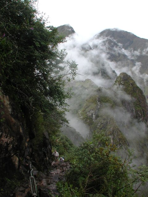
Shortly after meeting the British family, I could appreciate why they might have been spooked. The trail ahead dropped 100 feet and the exposure to one side was significant, although the trail was comfortably wide and not particularly threatening, unless you don't like looking 1,000' down to a jungle river. Once past the ridge, the trail rises steeply up the slopes of Huayna Picchu, alternating between switchbacks and stretches of Inca or modern steps. The steepest pitches are provided with either rope or steel cable handrails for stability. With the morning drizzle, the rocks were wet and a bit slick, so the handrails were appreciated for safety's sake as well as assistance in the climb. |
|
|
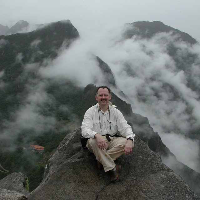
Near the summit, there is a grotto formed by several house-sized boulders leaning together. It takes a bit of hands-and-knees crawling to traverse the grotto, and you are then left in a gap among the summit boulders. The scramble to the summit itself involves a couple of third-class moves, mantling up on a 20 sloping slab of granite with several hundred feet of air under its downhill edge and then scrambling up to the perch carved out of the summit boulder itself. It is a comfortable seat, probably carved by the Incas so a lookout could stand there and survey the whole of Machu Picchu and the Inca Trail leading down from the Sun Gate in the saddle a couple of miles north of Machu Picchu. I ran into three other intrepid souls, variously from Britain, Singapore and Germany, at the summit, so we shared photo duties (and a hand to the least-accomplished of the three, who was a bit overwhelmed at the thought of sliding off the slick stones). The weather then closed in for a while, totally obscuring Machu Picchu, so we headed back down. |
|
Shortly after leaving the summit, you run into the only other third-class move of the climb. A large boulder bisects the trail, and passing it requires hanging onto the shoulder-height edge of the boulder and swinging a leg around the corner to the continuation of the trail, with your nether parts briefly hung out in space. Not the spot to let go, but merely a sporty spot to overcome. |
|
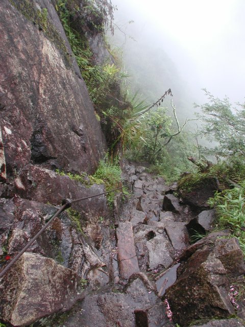
The trail then meanders around the far side of Huayna Picchu until you reach this Inca storehouse. The view down into the Urubamba valley is outstanding. Just below the storehouse is the toughest pitch of the whole trail. As evident from the two people climbing up from below in the photo to the left, it is steep, with six-inch-wide steps having eight to ten inch vertical spacing. There is no handrail on this pitch and I was happy to have my hiking staff along. Descending the steps required side-stepping because they were simply too narrow to walk straight down, especially still wet from the occasional mists. |
|
|
The steps then widen out a bit and the rest of the trail becomes easier, but still exposed to one side. The United Nations flair to the eclectic mix of climbers was further enhanced as I met a young man from Kenya on his way back down from the summit. |
|
|
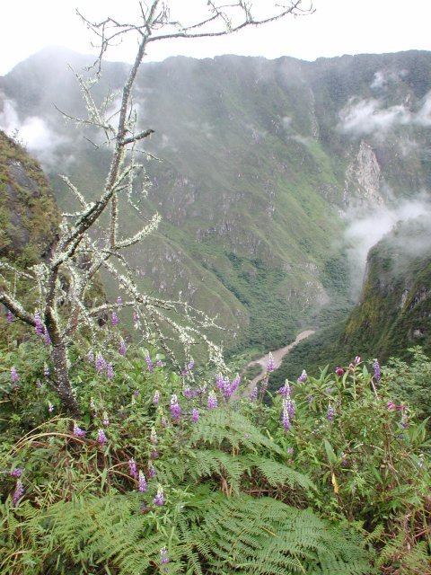
The Kenyan outpaced me on the way back to the knife-edge ridge. The cloud-forest nature of the area was emphasized by this moss-laden tree and the lupines which grow at this altitude. Interestingly, the Incas took advantage of the different microclimates at varying altitudes and with different solar exposure. At the level of the Urubamba river, below, it is quite tropical, making cultivation of bananas possible. From there upwards, the crops were matched to the changing conditions, with corn, then squash and finally potatoes grown on the terraces at different levels. |

|
|
Once again back safely to the trailhead. I had started at 7:10 and reached the summit of Huayna Picchu at 8:05, so just under an hour on the way up. We had waited a while on the summit for the weather to clear, but it wasn't promising. I returned to the trailhead about 9:45 after several photo-op stops and conversations with other folks just setting out for the summit. One of the resident lawn mowers greeted me upon my return, posing nicely for a photo after her(?) morning dust bath.
|
|
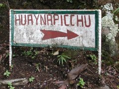
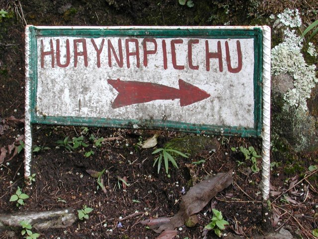
This sign marks the trail to Huayna Picchu.
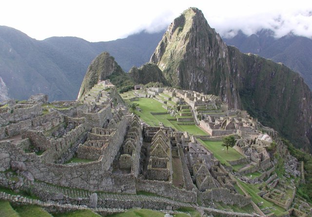
The postcard view of Machu Picchu looks from the slopes above it
and to the north toward the south. Huayna Picchu is the tall
sunlit spire in this photo.
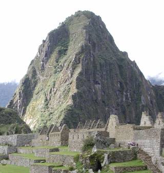
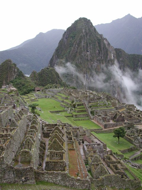
A closer look at Huayna Picchu shows that it is a steep pinnacle,
but one that the Incas domesticated five hundred years ago. Note
the agricultural terraces near the summit of the peak, in the
sunlight. Another even steeper set of terraces is visible in the
shadows to the left of the sunlit face. The ruins of a storehouse
are visible on the ridge above these shaded terraces. The crux pitch
of the descent follows the edge of the shaded terraces, in the
corner between them and the sunlit area.
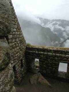
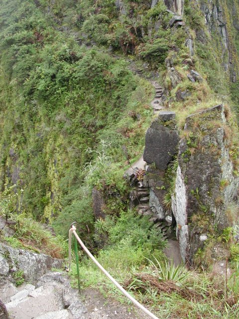
Morning light and drifting mists lend a different feel to
Machu Picchu. A light rain blew up (literally) occasionally
to punctuate a steady drizzle. The trail to Huayna Picchu
leads from the south end of Machu Picchu, between the two
thatch-roofed shelters immediately in front of the ridge
in the center left of this photo.
Looking past the shelters, you can see the gate and hut where
the signin log is kept. If you get there early, there may not
be anyone to record your name, but no one said anything when
I walked out a few hours later and explained that there had
been nowhere to sign in when I left the trailhead at 7:10 a.m.
Can you say "airy traverse?" Ok, by mountaineering
standards, it's a sidewalk, but for some of the tourists, this
marked their "I think it's time to turn around" revelation.
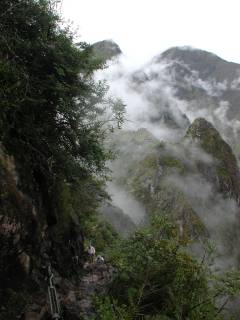
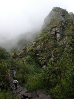
As the trail snakes its way up Huayna Picchu, the vista shifts
from the Urubamba river to a view back to Machu Picchu. Lost in
the mists of time, it seemed to await rediscovery despite the
fact that busloads of tourists would invade as soon as the morning
train from Cuzco arrived about 11 a.m.
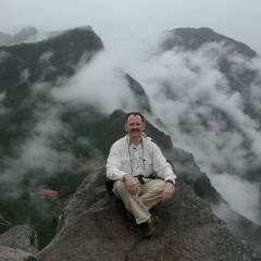
A bit of scrambling brings you to this boulder. I am sitting on
a nicely-carved platform that affords a panoramic view of Machu
Picchu, the Urubamba river far below, and a plethora of peaks
in all directions. Unfortunately, the clouds were closing in
by this time, limiting the vista significantly.
The red tile roof to the left of my perch is the restaurant and
visitor's center for Machu Picchu. Barely visible in the lower
left corner is one of the many switchbacks in the road leading
from Aguas Calientes up to Machu Picchu.
This Inca storehouse is the one visible in the shots of
Huayna Picchu from Machu Picchu. It commands an impressive
view of the Urubamba river valley below.
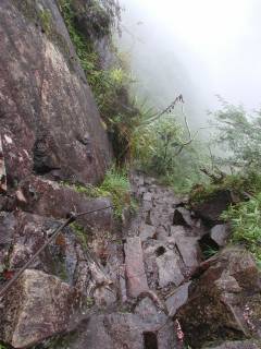
Just below the Inca storehouse, the steps become extremely
steep. Looking at the two climbers below, it is easy to
see just how steep, as the second climber is only 3 or 4 feet
behind the lead climber, but his head is below the level of
his partner's feet. These steps are narrow enough that it
was necessary to sidestep down them.
Below that one very steep pitch, the steps become more
gradual, leading to a few relatively flat spots in the
trail before you rejoin the stretch back across the
knife-edge ridge.
Once again, the backpacker's nightmare of "what goes down
must come back up" applies, as you drop well below the
level of Machu Picchu before crossing the ridge and ascending
100' or so back to the level of the trailhead.
The cloud forest nature of the area is apparent as moss
encrusts this dead tree. The lupines were actually cultivated
by the Incas as a food crop, requiring special preparation
since they are normally inedible.
Back safely to level ground. Huayna Picchu bids adios
in the background.
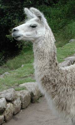
Trailhead welcoming committee and lawn mower. A small herd of
llamas patrol the ruins, cropping grass on the terraces and posing
for photos. Be aware that the Department of Agriculture inspectors
will insist on disinfecting your shoes when you return to the U.S.
after visiting Machu Picchu. It pays to have your shoes packed where
you can get to them so the inspector can spray them and get rid of
any (suspected) hoof-and-mouth contamination.
Machu Picchu and the Huayna Picchu Trailhead
Machu Picchu and the Huayna Picchu Trailhead
Machu Picchu and the Huayna Picchu Trailhead

The Upward Path - The Trail up Huayna Picchu
The Upward Path - The Trail up Huayna Picchu

The Upward Path - The Trail up Huayna Picchu
The Upward Path - The Trail up Huayna Picchu
The Return Path - Returning from Huayna Picchu

The Return Path - Returning from Huayna Picchu
The Return Path - Returning from Huayna Picchu
The Return Path - Returning from Huayna Picchu
The Return Path - Returning from Huayna Picchu
The Return Path - Returning from Huayna Picchu

The Return Path - Returning from Huayna Picchu