Since Richard Stover and I had climbed Triple Divide Peak (N) in the Clark Range on the southern border of Yosemite in June, we just had to balance things up by climbing the more impressive Triple Divide Peak, south this August. We left from the Horse Corral/Marvin Pass trailhead climbing 1000 feet in the first mile. Then we dropped 2000 feet to the Sugarloaf Creek drainage.
We were hot and tired and started a pattern that worked well for the duration of the trip. At about 2 or 3 in the afternoon most days we took a break, jumped in a creek, soaked off the trail grime, and rinsed out our clothes. Ahh, refreshing. Most days we put our clothes back on wet to protect ourselves from the hot sun. They dried very quickly.
Every creek or river crossing was easy this August, a major contrast to our backpack on the same trails to Colby Lake in 2005. The Brewer Creek Crossing was rebuilt by a trail crew about five years ago, eliminating a deep hole which made the crossing difficult. The log spanning Brewer Creek, however has broken, and I am not sure what one does during high water. In July of 2005 the Roaring River was up to my thighs, and I spilled all our maps as I crossed with difficulty above Big Wet Meadow.
We had planned to hike to Glacier Lake below Triple Divide Peak in three days, which seemed entirely reasonable since the distance is about 25 miles. However, on the third day we either overestimated our speed or underestimated the steep and rocky terrain. We started up the slope toward Glacier Lake at 4:20 p.m. By 7:30 we were not yet at the lake (about a 1500-foot gain). Prudence dictated that we set up camp in the best spot we could find. Not ideal, but safer than continuing in the dark.
At dawn we walked the remaining 20 minutes to the lake and got much needed water. That was supposed to be our climb day, but fate was looking out for us. By the time we had our tent set up, it was raining, so day four became a layover day.
Glacier Lake is very beautiful, and there are only a few small snow patches left where the map shows a permanent snow field. It is populated by a flock of American Pipits and one American Dipper.
Although there were clouds building in the morning of the fifth day, we started up the drainage toward Triple Divide Pass. The pass is easier than it looks, but I would not enjoy crossing it with a full pack. Once we gained the East Ridge, the climb was for the most part a fun third class scramble. In a few places we temporarily dropped to the south side of the ridge for easier passage.
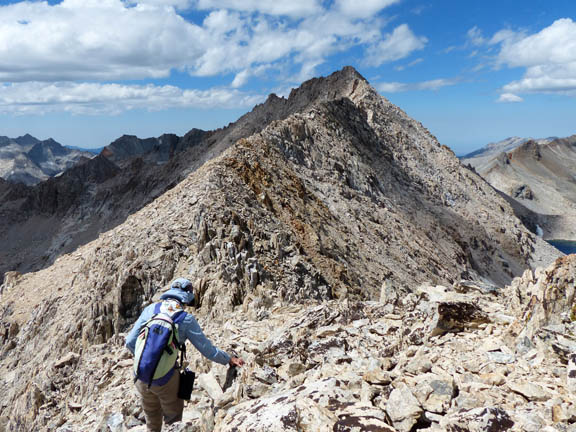
The sky was becoming increasingly more threatening as the day wore on, so we moved as quickly as we could. The view from the top of this special peak is awesome: Wilderness in every direction.
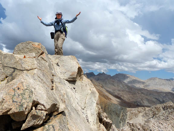
Because it was starting to rain, I spent only a few minutes with the summit register, then headed back. When the hail started, we dropped off the ridge for a few minutes, but the quickest way down was to stay on the ridge, so we did.
At times the lightning was blinding, brighter than usual. Especially bright flashes were followed by ear-splitting thunder which usually made me startle even though I knew it was coming. We had donned our rain jackets, but foolishly had not put on our rain pants. By the time we reached our tent, our pants were soaked through.
But our sleeping bags were warm and dry. Our tent vestibule held a pile of wet clothes as we warmed up and listened to the storm around us. At last we had a chance to eat most of the lunch we had neglected in our haste to descend.
It rained into the evening. The next morning we had lots of warming soup and tea while we dried out our gear, a process that took us until after noon. We then descended to Cloud Canyon where we managed to pitch our tent with minutes to spare before the rain started again, but not before we were treated to one of the best light shows we have ever seen. There was to be yet another rainy day before we could hike out.
As we neared the confluence of Roaring River and the creek that comes down from Colby Lake, we looked for Shorty's Cabin. Shorty Lovelace was a fur trapper who worked in Sequoia and Kings Canyon in the 1920s and 1930s before they became National Parks. He built as many as 37 cabins, each a day's ski apart, which he visited in winter.
Richard and I had searched for Shorty's Cabin on Roaring River in 2005 for over half an hour. It turned out that the cabin is not at the spot where it is indicated on the map. With new directions we found it in short order this time.
Below is a photo of me from Aug, 2013. The photo is looking south toward Cloud Canyon (uphill).
I am pointing to the turnoff spot for Shorty's cabin. The cabin is just a short distance from
the trail.
And here's the cabin! It is not visible from below hiking up.
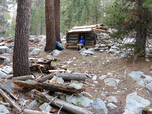
FYI, Shorty's cabin is at N 36 38' 49.4" / W 118 32' 05.3"
Cindy, the ranger at Roaring River, told us the cabin had been carefully disassembled and restored in the fall of 2012. It sported a new shake roof crafted on site as well as other repairs. Cindy also entertained us with stories of the "Grand Hotel" above Big Wet Meadow and other tales, but that's another story we don't have time for here.
Between visiting on Cindy's front porch and cleaning/swimming in the river, we didn't get very far that day. On day nine we hiked back to our vehicle (after climbing Mitchell Peak) having had one of our best adventures yet: A special peak, a found cabin, five lost balloons, and many interesting birds including the Pipits and Dipper, White-headed woodpeckers, Wrentits, Rufous hummingbirds, various Warblers, White-breasted Nuthatches, and a Brown Creeper.