Peak 12,774 is located 1 mi south of Mt McDuffie and 1 mi northwest of Wheel Mtn (UTM 11 353962E, 4102532N, NAD27). It is as high as the latter and clearly visible from Bishop Pass. Its southeast slopes are class 2, the summit block is class 3, and other routes are class 4-5. The access to the peak involves a major effort: From the east it is a 12-hour roundtrip from Ladder Creek (which is what we did). From the west it would be a heroic climb out of the Enchanted Gorge. A traverse from the south via Wheel or from the north via McDuffie would involve cl 4 terrain. Since it also takes two days to get even close to the peak it is no wonder that this unnamed peak is rarely, if at all, climbed. The lack of knowledge about this peak attracted me and there was only one way to find out whether R.J. was right, i.e., to look for a summit register.
On Tue, 8/31, we drove from L.A. to South Lake, picked up a wilderness permit on the way, and hiked to camp at the Bishop Lakes.
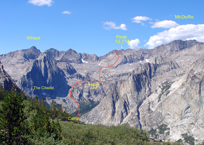
On Wed, 9/1, we climbed over Bishop Pass, descended Dusy Basin to LeConte Cyn, hiked down the John Muir Trail toward Ladder Creek. We found a suitable crossing of the Kings River at 8700' and started a diagonal XC ascent toward Ladder Creek. In retrospect, this was a mistake since it only prolonged the painful effort of uphill bushwhacking. To minimize the pain it is best to go straight uphill parallel to Ladder Creek on its north side at a suitable distance from the cl 3 slabs adjacent to the creek. The south side is not recommended because of steep cliffs. After ascending some 600' through chaparral the terrain changed to pleasant open forest and meadows. At about 9500' we set up camp since the further ascent to Ladder Lake would involve a steep climb with full packs.
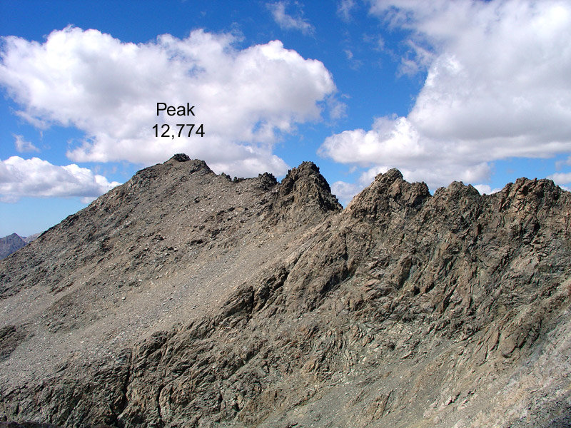
On Thur, 9/2, we were on our way by 6:45am. A predicted cold front had moved in with high winds and low clouds. We ascended steep slabs between Ladder Creek and the impressive north face of The Citadel. Then we contoured around the north side of Ladder Lake (10,498') since cliffs blocked the shorter south side. At the west end of the lake we turned south to a small, unnamed lake and followed the intermittent inlet stream in the SW direction. The stream comes from snowfields in a large cirque with a moraine. There is one obvious low col (12,100') on the west side of the cirque leading in the direction of our destination, but the chute is definitely cl 4 terrain. We left the cirque, turned NW and ascended from about 11,400' the cl 2 slopes toward the unnamed Lake 12,050' (UTM 11 354823E, 4103108N, NAD27). There were snowfields on its south shores and a sandy chute on the SW side of the lake. We decided to climb a cl 3 ridge SE of Lake 12,050' which got us into the 12,400' col at the top of the sandy chute. About 1/4mi to the south is another unnamed lake at 11,700' (11 354575E, 4102524N), which drains into the Enchanted Gorge. We descended SW toward Lake 11,700', staying above the lake but below the cliffs on its west side. We found a cl 3 chute that lead to the easy cl 2 east slopes of Peak 12,774. We aimed for the high point west of the lake and reached it at about 1pm. Unfortunately, it was the 12,720' sub peak about 0.1 mi NE of the true summit. There is a whole string of subpeaks along the NE ridge. After climbing for over 6 hours and 4000' up, Leslie decided to save her remaining energy for the long return. But she was essentially at our destination.
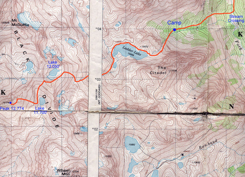
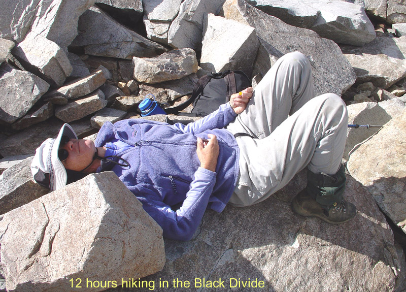
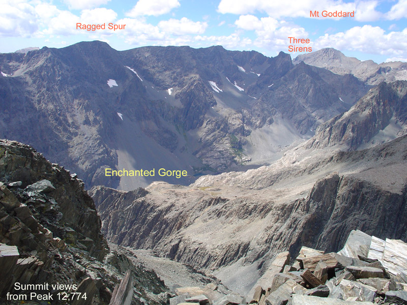
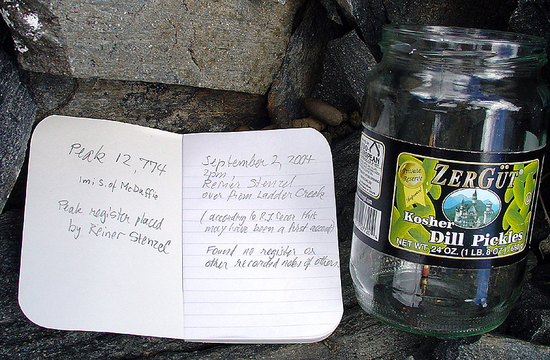
I dashed over to the high point (11 353946E, 4102505N), which had a nice cl 3 summit block. By 1:45pm I stood on Peak 12,774 and found a small pile of rocks on the top, which looked more man-made than natural. There was no register under it or elsewhere on the summit. Thus, the question of whether the peak was unclimbed is a matter of definition: Possibly a person placed a cairn on the summit but left no permanent record there. I would be very interested if anyone knows who might have been there. But from now on the peak does have a register book in a glass jar placed under a newly built summit cairn. Hopefully someone else will sign it some day. Although in a hurry, I took some pictures of the fine views from this peak. Nearby one could look down into the Enchanted Gorge, on Charybdis, Scylla and The Three Sirens, McDuffie, Goddard, Wheel and Devils Crags. Further to the west one could look over the Ragged Spur and Goddard Creek toward the White Divide and beyond. To the east was the Palisade Range and Bishop Pass we had crossed earlier.
By 2:30pm I was heading down and soon rejoined Leslie for our long hike out. It added another 600' climb up from about Lake 11,700' to Col 12,400'. This time we descended the sandy chute to Lake 12,050' and carefully crossed the snowfields on its south side. I looked back to the cl 4 ridge that we had once crossed with full packs to climb McDuffie and shook my head.
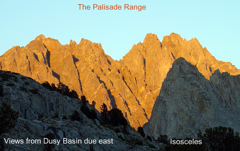
When descending from Lake 12,050' due east we dropped down too far and encountered cliffs below 11,200'. We had to reclimb some 200' up into the correct chute leading down along the creek to the small Ladder Lake. Shows that careful navigation is vital in this terrain. We contoured around Ladder Lake where we saw the last sunlight on the vertical walls of The Citadel reflecting in the lake. By 7:30pm we were back in camp, exhausted from climbing + - 5000' of talus in the Black Divide. I am sure the new peak register won't be filled for many years.
On Fri, 9/3, we made a rest day in the morning. When the weather deteriorated, we decided to hike down to the Kings River and up into Dusy Basin. It snowed intermittently. At night the water bottles froze.
On Sat, 9/4, we headed up to Bishop Pass. The cold front had moved through and left a spectacularly clear and calm day. Instead of hiking out we decided to climb in the Inconsolable Range. From Bishop Pass we found a fine trail heading east toward the chutes between Aperture and Agassiz. The trail ends near a moraine (11 363484E, 4108746N, 11,998') below the easiest-looking right (south) chute. This chute leads to a col (11 364045E, 4108565N, 12,941') which provides a XC route to Sam Mack Mdw. It is also the boundary between the Palisade Range and the Inconsolable Range. There was a fresh duck on the col indicating that people travel over it. The left (northern) chute leads to Jigsaw Pass (11 363864E, 4109119N, 12,756'), which provides a cl 3 ascent of Aperture Peak that we climbed last year. The middle chute is cl 4 on both sides. We climbed the "easy" chute to the col where Leslie found a peak register can hidden under rocks. It was a fine SRC canister for Aperture Peak! The book had one single entry from 10 years ago by a 71-year old man who had apparently delivered the can but not climbed the peak. In fact, from the pass it would be a technical climb to both Aperture and Agassiz. Since it was obviously at the wrong place we packed it up for proper placement. We dropped down the east side of the col, circumnavigate Aperture Pk and reclimbed Jigsaw Pass from the east.
There are large snowfields and a long moraine on the rugged northeast side of Agassiz and Aperture. Below the steep east face of Aperture we stumbled upon the next surprise: On top of a flat talus block there was an abandoned campsite (11 364265E, 4108687N). Everything was left behind: Two tents, backpacks, clothes, stoves, pots, shoes, ice screw, rope, slings, fishing gear, etc. Judging from the decay it must have been there for one season or more. I saved a tape recorder from the debris to do some further research. Hoping to find no more surprises we contoured around the long NE ridge of Aperture and climbed Jigsaw Pass. Since time was running short we deposited the Aperture peak register at Jigsaw pass with a note for the next climbing party to bring it up to the summit. Then we descended, retrieved our packs, and headed down to the Bishop Lakes to make camp just before darkness. Next day we hiked out and drove home after an adventurous trip in the Sierra backcountry.


Steve Eckert adds:
>The access to the peak involves a major effort: From the east it is a 12-hour roundtrip from
>Ladder Creek (which is what we did). From the west it would be a heroic climb out of the Enchanted Gorge.
Not so heroic on snow! We came down Enchanted Gorge and climbed McDuffie in 1995, then exited past Ladder Lake and Bishop Pass.
Your report stirred up great memories, but reminded me that I need to go back when there's not so much snow if I want to know what the terrain is really like. We glissaded Enchanted Gorge on the 4th of July weekend... and saw someone telemark from the summit of Goddard the day after we were there. Big snow year!
Debbie Bulger adds:
Perhaps the abandoned campsite belonged to the 2 members of the yellow-legged frog survey team. (working for F&G). One of them was killed in a fall in that area a couple of years ago when they went climbing on a non-working day. I met them behind Mt.Wynne earlier in the season.