I set out to climb Mt Baldwin as a day hike. The trail along the eastern shore of Convict Lake was barely painted by the light of the waning crescent. I didn't bother switching on my headlamp. I splashed across Convict Creek in the first light of day, and continued up to Lake Mildred. I turned southeast, cross-country, at Mildred Lake, but I learned later that there is a better route. I stamped up to the alluvial fan below the north face of Mt Baldwin.
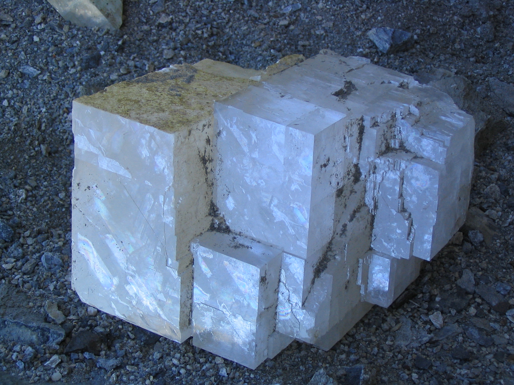
In the fan, I met two geologists from Mammoth Lakes, Doug Jung and Brigitte Berman. They gave me some accurate directions and asked me to explore an old mine on the upper slopes. They explained that Bausch & Lomb used to collect optical grade calcite there. I recalled from my school days that calcite is the textbook example of a birefringent crystal, one capable of splitting light rays into two components that travel at different velocities and are polarized at right angles to one another. (You should have gone to my school.) Calcite is calcium carbonate, chemically just like chalk, but very different from chalk in its crystalline structure and optical properties.
I walked north up a use trail toward Bright Dot Lake, and then turned southeast cross-country up a ramp that led to a deep gully on the face of the mountain. There is a pinnacle in the center of the gully, barely visible from outside, and the calcite diggings are on the south side of the pinnacle. The gully is too shallow and the pinnacle too short to appear on the 7.5 minute map of the area. Doug and Brigitte requested a waypoint:
N   37 deg 31 min 59.6 sec
W 118 deg 51 min 16.9 sec
11783 feet
NAD27 CONUS
The mine wasn't a deep pit at all. The calcite was gathered primarily at the surface. There were substantial piles of crystals that were left behind, presumably because they lacked the prized transparency. But I did find several specimens, 3 or 4 centimeters long on each rhombic edge, and as clear as glass. I could read my map through them and I delighted in the curious optical effects they made. I found some less transparent crystals as big as 15 centimeters on the side.
Above the mine, the mountain is bare and smooth. It rounds gently to a summit at 12615 feet with a photogenic view of the neighboring peaks in this geologically fascinating area.
On descent, I discovered that there is a use trail all the way to the summit, but I didn't see it on the way up. The trail drops down further south from where I climbed, passes by the mine, traverses a slope to the east of the ramp, and joins the Bright Dot use trail. At the alluvial fan, I saw that the trail continued down to a point in the Convict Creek hanging valley considerably further than Mildred Lake. If I had continued up the valley almost all the way to where the valley ends in a headwall, my hike would have been easier.
On the bank of Convict Creek, I came upon the campsite of Doug and Brigitte. I gave them my best calcite samples. I didn't know how to evaluate the quality of the stones, but Doug said they were as good as calcite gets. They warmed my bones with some tomato soup and sent me on my way back down to the Convict Lake trailhead with what remained of that crystalline day on Mt Baldwin.