clyde min-a-ret: n. 1. A tall, slender peak south of Ritter/Banner, having steep 3rd to 5th class faces from which a register summons the people to climb.
My prior attempt on this peak (in 1998) had gotten us all to the summit but ran so late as to endanger everyone's safety. This time I needed to carry if off "in good style" if only to settle the score with myself. This time we allowed three days instead of two. Click on the pictures below for larger images.
| Less than six hours of hiking got us past Ediza Lake to Cecile Lake, so even with frequent breaks we were there by mid-afternoon. |
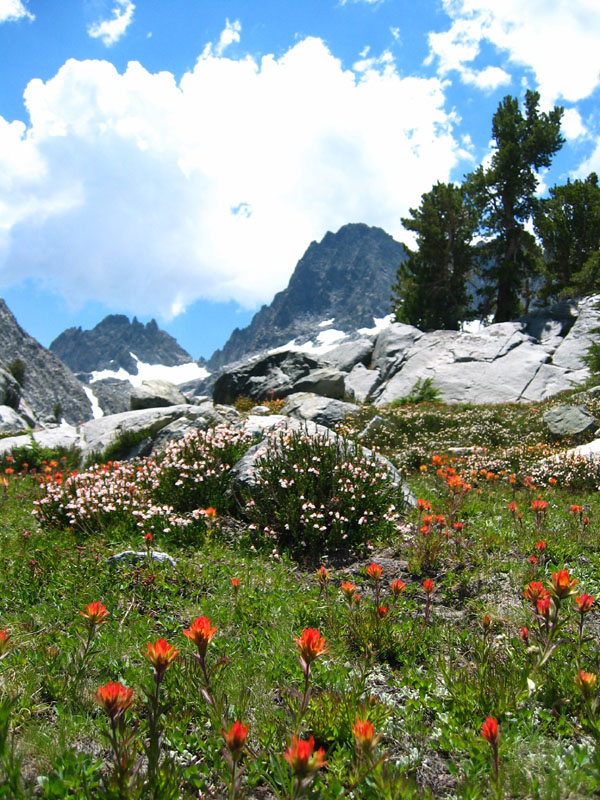
| The classic views over Ediza and the wildflowers above it went well with the growing clouds, but I remembered the hours-long rain storm from the day before and wondered what our chances were. |
|
The clouds huffed and puffed and went away. We lazed around our cluster of campsites (in the trees west of Cecile's outlet) and wondered where all the snow had gone. No bergschrund like the last time, but since it was July instead of October there were a lot more people in the area. We heard barking dogs down at Iceberg Lake, we saw horses go off-trail around Ediza Lake, and perhaps a dozen hikers came up to Cecile just to look around. We saw no other climbers.
Saturday morning dawned clear and warm and calm. 10000 feet and I hadn't even zipped up my sleeping bag. Monsoon clouds still lurked over the desert. We headed up the slope shortly after 6am, getting to the polished slabs hours earlier than my last attempt. The snow was hard, and everyone ended up putting on crampons even though you could kick into it if you tried. (I broke my leg just four months ago, this being my first post-break-peak, and I wasn't in the mood to kick hard or fall!)
Ditching crampons and ice axes, we eased up the rubble above the snow and onto the Rock Route Ramp. Piece of cake. Looks like coming up the glacier to the north end of that ramp would be even easier, and we saw some footsteps in the snow where someone had checked out that approach, but we never found out who.
Turning up the obvious chute to the right of that famous gendarme that separates the Rock and Starr routes, we had trouble figuring out exactly where previous groups had hit what they called fourth class. There were tough spots, but we generally managed to work around them with careful scouting. I'm a wimp when it comes to 4th class, but no one asked for a rope the whole way up. As we got high enough that the gendarme LOOKED like a gendarme (instead of a rib as it appears when starting the route) we shifted to the right (down from the rib) a bit to avoid the larger blocks to our left.
| Thinking we needed to angle left into some sort of bowl, and seeing a steep headwall above us, we hit the rib 200 feet below the summit. The next chute left was, I now believe, the top of the Central Route. The notch at the top looked less tough than what was above us to the right of the rib, and there was a Class 2-3 ramp that lead down across the otherwise Class 5 rib edge into the chute, so we went for it. |
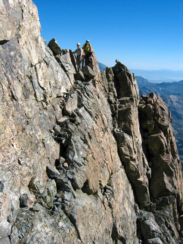
| Sure enough, the top of this chute was the square "gunsight notch" you can see all the way from Cecile. Crossing the rib where we did connected the Rock Route to the summit without that standard "10-foot Class 4 move along the ridge", and we thought climbing directly up to the notch was Class 3 (no rope used on the way up, but we did rappel one pitch where there were old slings when coming down). If we were in the Central Chute, the part below where we crossed into it looked like damn loose rubble. The square notch is 50' below the summit. |
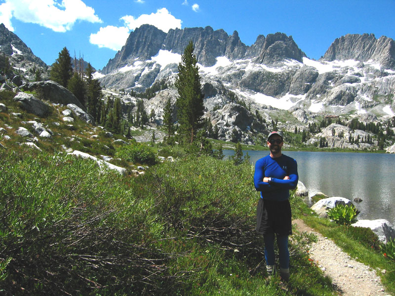
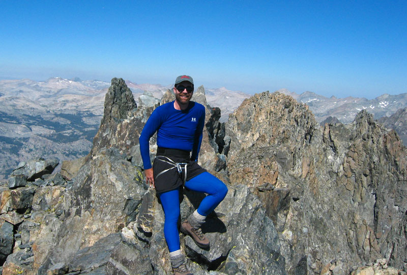
| Imagine my happiness to summit at 9:30am instead of 3:30pm like last time! We hung out for almost an hour, enjoying mild temps and a gentle breeze and the flush of a perfect climb. No tempers, no ropes, no rockfall (unless you count that one that came down by itself while we were still on the snow), and no one left behind. Cool. 3.5 hours for 2000' of 3rd class is no record, but we enjoyed it. (That's me on the summit with my one-biner one-sling "rap harness".) |
|
We found a 1988 register entry from Schuman and Head that said "attitude over altitude", and mentioned something about 17 hours from Ediza Lake. Aaron says they were back in camp by midnight but it must have been an epic! I think camping at Cecile is the only way to go...
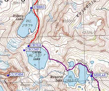
As always, downclimbing sustained 3rd class takes longer than going up, but we were back in camp by 2:30pm and only used the rope for the first pitch down from the square (Central Chute) notch. We decided to break camp, turning it into a two-day loop trip by hiking out past Minaret Lake (don't follow the inlet to Minaret Lake, go past the small lake east of Cecile - see map below) and catching the Devils Postpile bus (at 7:15pm) back to the cars at Agnew Meadow before dark. Old reports indicate problems crossing the stream near the Postpile trailhead, but the new steel-and-wood bridge fixes that. Free bus ride, free hot springs shower at Red's Meadow Campground, cold beer from Red's Meadow General Store, pizza in Mammoth for dinner, a moonlit night in the tall trees near Deadman Summit, home the next morning.
Thanks to all participants for making this a wonderful return to the mountains for me - and for helping erase the memory of my bad judgements on the prior trip.
Waypoints and a link to an interactive map are below, here's a static map:
![]() Download the Waypoint+ data below as a GPX file for your GPS.
Download the Waypoint+ data below as a GPX file for your GPS.
Datum,North America 1983,GRS 80,0,-1.6E-7,0,0,0
RouteName,1 ,SOUTHERN ENTRY
RoutePoint,D,MSCAMP, 37.6543800831,-119.0611381531,07/29/2004,22:02:16,MINARET SUMMIT CAMPING SPOT
RoutePoint,D,DPPCAR, 37.6319226027,-119.0829441547,07/27/2004,03:40:13,DEVILS PP OVERNIGHT PARKING
RoutePoint,D,DEVILS, 37.6297399998,-119.0846999884,10/16/1998,09:00:18,DEVILS POSTPILE TRAILHEAD
RoutePoint,D,DPPBRG, 37.6268270016,-119.0856814384,07/29/2004,22:46:25,DEVILS PP FOOT BRIDGE
RoutePoint,D,JOHNST, 37.6471600533,-119.0998699665,10/16/1998,09:00:18,JOHNSTON TR JCT
RoutePoint,D,MINETR, 37.6523799896,-119.1340299845,10/16/1998,09:00:18,MINE TR JCT
RoutePoint,D,MINLAK, 37.6602300406,-119.1533600092,10/16/1998,09:00:18,MINARET LAKE
RoutePoint,D,CECILE, 37.6662100554,-119.1689100266,10/16/1998,09:00:18,CECILE LAKE 10.2K
RoutePoint,D,CECCMP, 37.6654000282,-119.1699600220,07/27/2004,03:29:47,CECILE LAKE CAMPSITE
RoutePoint,D,CLYDEM, 37.6604199409,-119.1739699841,10/16/1998,09:00:18,CLYDE MINARET 10.3K
RouteName,2 ,NORTHERN ENTRY
RoutePoint,D,MSCAMP, 37.6543800831,-119.0611381531,07/29/2004,22:02:16,MINARET SUMMIT CAMPING SPOT
RoutePoint,D,AGNWRD, 37.6812000275,-119.0805799961,05/26/2004,18:24:54,AGNEW MDW ROAD TURNOFF
RoutePoint,D,AGNWHI, 37.6827399731,-119.0846400261,10/16/1998,09:00:18,AGNEW MDW HIGH TRAILHEAD
RoutePoint,D,AGNWSR, 37.6820927858,-119.0861274004,07/29/2004,22:08:30,AGNEW MDW SHADOW AND RIVER TRAILHEAD
RoutePoint,D,AGNWHC, 37.6827700138,-119.0919699669,07/27/2004,03:40:13,AGNEW MDW HORSE CAMP TRAILHEAD
RoutePoint,D,AGNMDW, 37.6820600033,-119.0943200588,07/27/2004,03:29:47,AGNEW MEADOW USE TRAIL
RoutePoint,D,AGNCUT, 37.6820805073,-119.0957540274,07/27/2004,03:29:46,AGNEW MDW SHORTCUT JCT
RoutePoint,D,AGNEWJ, 37.6871900558,-119.1059700251,10/16/1998,09:00:18,AGNEW MDW JCT 8K
RoutePoint,D,RIVSHD, 37.6966600418,-119.1162500381,05/26/2004,18:15:42,RIVER SHADOW JCT 8.1K
RoutePoint,D,SHADWL, 37.6946600676,-119.1284527779,05/26/2004,21:14:07,SHADOW LK 8.7K
RoutePoint,D,MUIRTJ, 37.6909300089,-119.1453800201,10/16/1998,09:00:18,MUIR TRAIL JCT
RoutePoint,D,EDIZAL, 37.6871399879,-119.1643799543,10/16/1998,09:00:18,EDIZA LAKE 9.3K
RoutePoint,D,ICEBRG, 37.6737881899,-119.1682715416,05/26/2004,21:08:27,ICEBERG LK  9.8K
RoutePoint,D,CECILE, 37.6662100554,-119.1689100266,10/16/1998,09:00:18,CECILE LAKE 10.2K
RoutePoint,D,CECCMP, 37.6654000282,-119.1699600220,07/27/2004,03:29:47,CECILE LAKE CAMPSITE
RoutePoint,D,CLYDEM, 37.6604199409,-119.1739699841,10/16/1998,09:00:18,CLYDE MINARET 10.3K