|
Utah/Idaho |
| Utah -- Idaho |
Saturday, June 26, 2004
Time once again for another highpointing
epic. With just a week to spend, we picked Kings Peak, Utah and Borah Peak,
Idaho as reasonable goals.
We flew to Salt Lake City and after a stop at REI to pick up a butane canister
for my new stove (no more packing my old Svea with post-9/11 controls in place),
we headed up to Evanston, WY, for the night.
Sunday, June 27, 2004
We drove east, then south down to Mountain View, WY, and headed off on
the Forest Service roads toward the Henry's Fork campground and the
trailhead for Kings Peak. We met up with Jerry Bresnahan, a fellow
highpointer on his way through the West to the Club konvention at
Mt. Rainier. An omen of things to come, we were pleted with slushy
hail and rain for a couple of hours, so we waited in the cars for
things to clear. Around 2 p.m., we decided that it was time to
head in, weather or not, so we shouldered our packs and hit the trail.
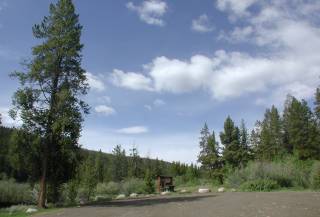
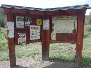
We signed in at the trailhead and headed up along the Henrys Fork drainage.
The trail climbs steadily, with just a couple of minor downhill pitches (that
would prove annoying coming back out in a few days). Near the Elkhorn Crossing,
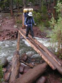
an intersection of several main trails, you have to cross this log footbridge.
With the rain and less-than stable logs, we were taking our time crossing the
snowmelt-swollen Henrys Fork. The bridge is high enough above water level that
a fall would be dangerous, plus the fast-running water would pose a significant
threat if you fell in.
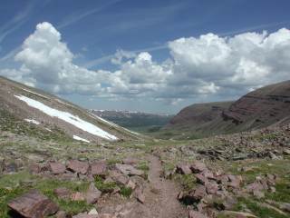
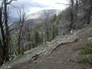
After the footbridge, we continued up the other side of the Henrys Fork
valley. The rain finally let up, improving our spirits if not the
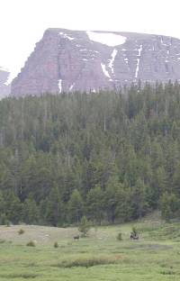
footing on the muddy trail. Across the valley, we saw our first moose of the
trip, two cows and a bull barely visible near the bottom of this view.
We had heard from Kevin Baker that the trail turned very nasty just before
our planned campsite at Dollar Lake. Kevin was all too right, as the
trail cut through a willow swamp. The trail (if you can call it that) had
been so torn up by horses that it was knee-deep in mud. We opted for
bush-whacking (quite literally) through the chest-high willows to find
enough hummocks that would hold our weight without sinking into the marshy
ground and flowing sheets of water. It took an hour to negotiate less
than half a mile of that stretch, and we were more than glad to put that
particular pitch behind us (although we knew we'd have to do it all over
again in a few days!).
Monday, June 28, 2004
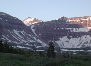
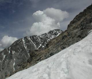
The sun rose as we hiked up the trail toward Gunsight Pass, revealing
Kings Peak through a notch leading up to Anderson Pass. At that point,
things looked promising...
The route up to Gunsight Pass was easy enough...a few patches of snow, but
nothing requiring us to break out ice axes and crampons. We took a brief
break at the pass and I spotted what I thought was the use trail described
in the Wingers' book. At least it was a clear trail with a couple of
cairns visible before it headed across some rather blocky talus.
After an hour or more of tough rock-hopping, we realized we were not making
progress at the rate we needed to. Plus, there were building puffs of
cumulus over the Painter Basin below us. We finally rounded enough of
the curve in the hillside and saw that the clouds were, indeed, building
over Kings Peak. At that point, we realized that the summit would not
be ours that day, so we descended to the base of the talus and picked up
yet another use trail back toward Gunsight Pass.
Looking back along the talus slope toward Gunsight Pass, we should have
headed uphill instead of trying to contour along the side of the hill.
Indeed, re-reading the Wingers' route description back at camp that night,
I realized that we had headed basically due south from Gunsight Pass,
rather than southwest as they directed. What I did not see from
the pass was any trace of a trail heading up and southwest. Hindsight
being 20/20, I should have stopped and re-read the route description and
consulted my compass instead of accepting the obvious use trail as the
right one.
When we got back up to Gunsight Pass, we took a break and ate
an early lunch. The view to the south/southwest from the pass
showed South Kings Peak in the distance with clouds building
over and to the north of it. Looking the other way, the clouds
were already building rapidly by 11:00 a.m.
We stopped at the bottom of the snowfields below Gunsight Pass
to pump water for the hike back to camp. As we did so, the
thunder started overhead and we were pelted by snow pellets,
further confirming that we had made the sensible decision not
to try to continue up Kings Peak that day.
When we got back to camp, Jerry was waiting for us, having opted to
sleep in and recover from the previous day's hike. It rained on and
off most of the afternoon, but never hard enough to penetrate the
overhanging trees, so we discussed options for the next day.
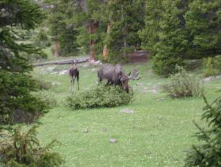
As we were preparing dinner, we noticed some visitors about a hundred
yards from our tents. Two bull moose (where's Teddy Roosevelt when
you need him?) and a cow were grazing on the shrubs in the meadow
between our campsite and Dollar Lake. As I walked down to pump water
after dinner, I found that they had taken up residence at an unoccupied
campsite nearer the lake. Leaving a prudent distance between them and
me, I carried full Platypus water bags back up to camp.
We planned another early start the next morning, once again hoping for
better weather. The clouds cleared overnight and the stars were bright
when I looked out about midnight.
Tuesday, June 29, 2004
Getting up at 3:45, there were still stars visible, but by the time
we hit the trail by headlamp at 4:00, there was a moderate haze
obscuring most of the stars. We continued to a point about 2/3 of the
way toward Gunsight Pass and, as the sky began to lighten with the
impending dawn, saw that the clouds were once again building. We waited
a half-hour or so, hoping that sunrise would bring better views and
better news, but were sorely disappointed. There was not just a layer
of high clouds, but already building cumulus coming over the ridge.
So much for a better weather day.
We turned around and headed back to camp. We had used our weather day
for Kings Peak and decided that we might as well head back to the trailhead
and try again another season. The thunder started behind us as we made our
way through the willow swamp (which was only marginally easier now that we
knew what we would face) and rain showers hit us sporadically as we made
our way back to the trailhead.
Once back to the car, we loaded up our backpacks, left Jerry a note saying
when we had gotten to the trailhead and headed over to Logan, Utah for the
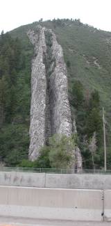
night. Along the way, we passed an area with multiple volcanic dikes exposed
along a hillside, one of which is referred to as the "Devil's Slide."
Wednesday, June 30, 2004
We slept in a bit on Wednesday and visited the Tyco printed circuit board
facility in Logan, where the division of Bausch & Lomb that I work for buys
their blank PCBs for our surgical equipment. After lunch, we headed north
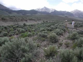
into Idaho, heading for the thriving metropolis of MacKay, Idaho.
After checking in at the Wagon Wheel Motel, we drove the 20 miles to
reconnoiter the Borah Peak trailhead for the next day. It is well marked,
and the gravel road to the trailhead is a bit rough but easily passable in
a normal car.
Thursday, July 1, 2004
Once again, we arose at 4:00 a.m. and headed up to the trailhead. We
were on the trail by first light at 5:30 and quickly found out why Borah
Peak is rated "strenuous" by both the Wingers and Holmes.
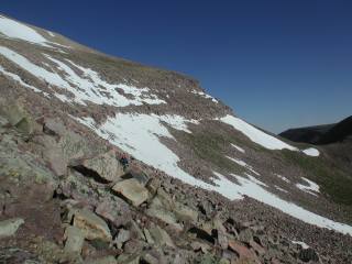
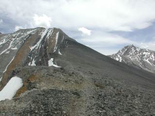
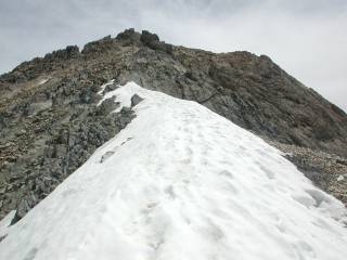
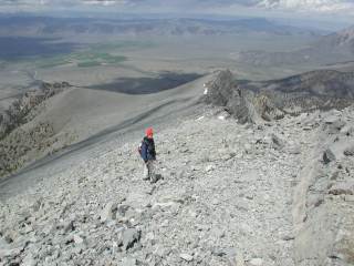
Looking over even the lower parts of the trail, the grade is ridiculously
steep, something approaching 40% for long stretches. Once you get above
timberline and onto the ridge, it's a little less brutal but still
definitely goes "up" quickly. The image to the right was actually shot
on our way back down, but gives a good sense of the trail as it skirts
the ridge. To the left, the drop is precipitous down into the valley,
and most of the remnant snowfields are corniced and definitely not safe to
walk out on.
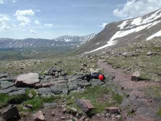
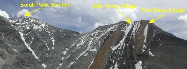
We thought we were doing fairly well until we got to this spot just
below Chicken-Out Ridge. We had expected the main snow bridge after
Chicken-Out Ridge, but this one was a surprise. The patch of snow
was only 50' or 60' long, but its top sloped up at a 20-degree angle
and looked pretty icy. To the left was a very steep (60) snow
chute that dropped far off into the valley. To the right, there was
a patch of gravel at first, but then the snow continued 20 or 30 feet
down to a cliff. There was an area perhaps 10 or 15 feet long that
was exposed to both hazards simultaneously.
I set up a belay spot for Nathan and went up with ice axe and crampons,
finding a fairly stable spot from which to belay him as he climbed up.
Fortunately, the surface turned out to be firm but not as icy as the
reflections had led me to believe and neither of us had any problems
getting up the snow, although we both were relieved to get past the
most-exposed parts.
Once above the snow, the use trail became jumbled and ran out,
leaving us faced with some steep third-class climbing to get
up to Chicken-Out Ridge. I scrambled up high enough to look
over the ridge to the summit and was greeted by a huge pile of
cumulus clouds building just behind Borah Peak. At that point,
it was clear that we would not have time to safely reach the
summit, especially considering we had another patch of very
exposed snow to cross.
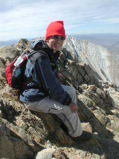
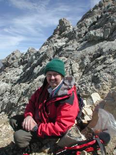
At that point, we took a couple of photos to show how high we
had managed to get and began our retreat back to the car.
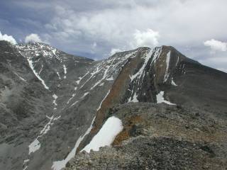
The salient features are identified in the photo above. The snow bridge
and its exposure are visible on the right. Chicken-Out Ridge is between
there and the main (expected) snow bridge, which obviously has its own
"interesting" exposure. From there, the summit is up and along the
remaining ridgeline. I figured it would have taken us at least an hour-and-a-half
up to the summit from the beginning of Chicken-Out Ridge, and at least an
hour back to where we were. Given the rapidly-building clouds, there was
no way we would be back off the ridge and below timberline before the storms
started, so the only prudent thing to do was to back down and leave Borah
Peak for another day.
Back across the snow bridge, we could see just how rapidly the
weather was building over the peak. Definitely not the time to
be up there on an exposed ridge or the summit!
As we retreated, we continued to watch the clouds build and drift
over Borah as we looked across the valley between the approach
and summit ridges. (Basically, you walk in a large 'U' to get
to the summit. The trail circles around skirting the ridge
most of the way, although Chicken-Out Ridge is literally along
the top of the knife-edge ridge.)
We hadn't yet made it down off the ridge when we were pelted
by snow pellets. Fortunately, the clouds that dropped the
snow on us weren't building into thunderheads (yet), but we
wasted little time on this relatively easy stretch of the
trail.
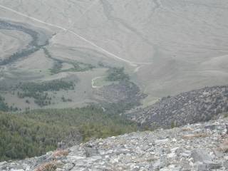
Just before you drop off the ridgeline and back into the really
steep part of the trail, you get a view back into the Lost River
valley. The car is tantalizingly visible, a small white dot in
the center of this shot at the wide area at the end of the road.
You're probably only a mile, line-of-sight, from the car at this
point but have the hardest hiking yet to do, even though it's
all downhill from there. Nathan was prompted to wish for a
hang glider...not a bad idea if you had a friendly pack animal
to haul it up for you!!
Stormed off our second planned highpoint, wandered a bit farther up
highway 93, to a site where the fault scarp from the 1983 magnitude 7
earthquate is particularly visible on the surface. The fault shifted
Borah Peak up a foot or so, and the neighboring valley down several
feet. At this point, the scarp appears as a square ditch with a larger
bank on the mountain side of the ditch. The Borah Peak access road
crosses the scarp in a large switchback, although the original route
of the road is still visible where it dead-ends in the scarp.
After marveling at Mother Nature's handiwork, we returned to MacKay for
the night, eating dinner at the Bear Bottom Inn (no, I'm not kidding!).
Decent Mexican food, kitschy atmosphere, and good beer! We repacked
for a possible second try at Borah the next day, but also packed the
rest of our gear, planning on departing the area either way.
Friday, July 2, 2004
I woke up early Friday morning and looked outside to see clouds
already gathering at 4:00 a.m. Between that and a less-than-promising
weather forecast, I decided it wasn't worth even trying Borah Peak
a second time, so we slept in a bit, finished loading the car and
headed back toward Salt Lake City.
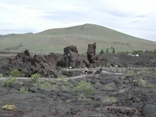
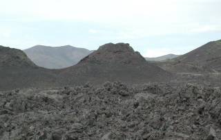
Not far south of the town of Arco, Idaho, is Craters of the Moon National
Monument. The site of repeated lava flows covering over 80 square
miles of territory, it has an incredibly varied volcanic topography,
including cinder gardens, cinder cones, aa (rough extruded lava) and
pahoehoe (smoother flowing or ropey lava). There are several lava
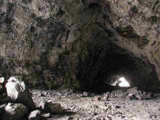
tubes or tunnels that are open and accessible, as well. Some of these
require a flashlight to explore while the largest, Indian Tunnel, has
enough openings in the roof that you can wander its length by available
light.
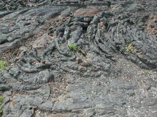
The blocky, aa, lava is extruded at a lower temperature and breaks
into chunks as it cools. The more fluid, pahoehoe, lava flows out
at higher temperatures and forms tunnels, smooth surfaces and occasionally
this taffy-like ropey surface.
Craters of the Moon is one of those spots where I could spend several
days with my cameras and come back with hundreds of shots of different
landforms and details of the lava. The lava tubes, or tunnels, vary
from low-ceilinged crawls to this, the "Indian Tunnel" which is large
enough in diameter to hold a good-sized house and is accessible for the
better part of a mile. I took a couple of panoramas, one of the interior
of Indian Tunnel, the other of the Devil's Orchard,
an area of cinder gardens with bizarrely-twisted trees. (Note that the
image files for the pans are in excess of a half-meg, so they will take a
while to load on dial-up lines!)
After Craters of the Moon, we stopped at Pickles Place (yes, that's the name!)
in Arco, Idaho, for a late lunch. On the way out to MacKay, I had noticed
a sign for the EBR-1 reactor site, so as we made our way from Arco to Pocatello
for the night, we stopped at the site of the world's first fast-breeder
reactor, now operated as a museum documenting some of the early efforts in
fission power plants. Indeed, Arco boasts of being the first town in the
United States illuminated by power generated in a nuclear plant.
Saturday, July 3, 2004
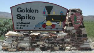
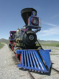
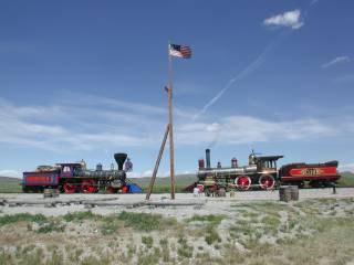
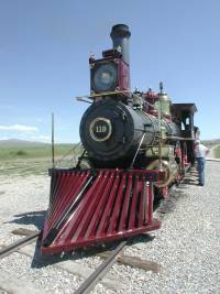
When we first set out from Salt Lake City, Nathan had asked whether the
Golden Spike had been driven in Utah? I replied that it had, at Promontory,
and suggested he look it up on the Utah map. It turns out that our
return route to Salt Lake City would take us within 20 or 25 miles of
the site, so we stopped off there on our way back.
We're a railroad family, with three generations having worked for the
Missouri Pacific, Frisco and KATY over the years. Nathan has started
volunteering at the Museum of Transport
here in St. Louis this summer, so he has become interested in railroads,
as well. The Golden Spike site was a natural spot for us to visit.
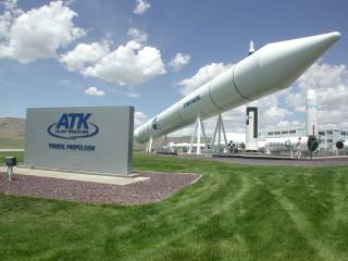
On the way to the Golden Spike site, we saw signs for a "Rocket Garden."
Intrigued, we followed them to the ATK Thiokol (formerly Morton Thiokol)
facility nearby. There is a static display of a number of different
Thiokol rocket mockups, including a full-size mockup of a Space Shuttle
solid rocket booster. Worth a few minutes on a sunny day, anyway...
From there, we headed on into Salt Lake City, settling into the airport
Holiday Inn as a convenient spot from which to get to the airport for
our flight home the next morning.
Sunday, July 4, 2004
The flights home were uneventful, and we arrived back in St. Louis
in time for dinner and Fourth of July fireworks. The weather did
not treat us well on either Kings Peak or Borah Peak, but we came
back in the same number of pieces as we started, so the trip met
the primary requirement for climbers. We'll try again in a few
years and, with better awareness of the routes and probable difficulties,
we will be better prepared for both peaks.
Even an unsuccessful trip is an opportunity to get up into the
mountains again, explore some new territory and enjoy time away from
the demands of work.
Respectfully submitted by
Alan Ritter, July 2004

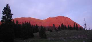
Arriving at last at Dollar Lake, we set up camp and waited for Jerry to
catch up with us. As he arrived, we were treated to the alpenglow on
the ridge above our campsite. We prepared dinner in the gathering gloom
and sacked out, our alarms set for 4:00 a.m. the next morning in the
hopes of waking to improving weather.
The Eclectic Traveler
To file a trip report, please fill in the Report Entry form or contact the webmaster.