Tim Hult and I, being unemployable, decided to take a week off from our duties and busywork. Archived trip reports indicate northeastern Nevada is most often done later in the season when the snow is gone, but I'd highly recommend re-thinking the timing in light of the great snow conditions we found. Earlier seemed easier to us.
We drove east on I-80, dropping onto US-50 at Fernley NV. This is a pretty fun place, where there's a three-way intersection where all highways are US-50, two parallel US-95's 20 miles apart, and several intersections between 50 and 95. Just keep following signs to Fallon and Ely, and perhaps keep an eye on your GPS or compass. US-50, once you get on it, is a great 2-lane highway. We spent the night just off a dirt road near Austin Summit, which was high enough to get some altitude acclimatization overnight, then drove on through Ely to the park.
Great Basin National Park is a refreshingly undeveloped place with no entrance fees, no backcountry permits, deserted campgrounds (at this time of year), and a fresh foot or two of snow from a recent storm. The snow basically melted off in the 3 days we were there, and we never used crampons/axes/snowshoes. The visitor center sells a very nice topo map of the park for $4, which even marks trailhead elevations.
We picked the Baker Lake trail from Michael White's backpacking guide book, planning to do a loop and come out past Johnson Lake and some mining ruins. The pack in from the Baker Creek trailhead (waypoint BAKETH, 8000') took only 4.5 hours (2600' gain), through wonderful birch and aspen and pine groves. There is a rushing stream the whole way, some meadows, and a spring or two. Beautiful! We matched the scenery to various Sierra Nevada trails, but the mix was always a bit different.
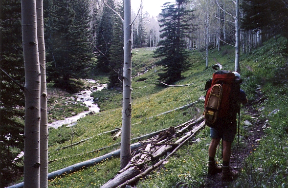
Mixed forest at about 9200', following Baker Creek on the Baker Lake trail.
We hit the first patches of snow around 9100', and it was nearly continuous in the trees by 10400'. The nature of the trail changes above the spring and stream junction at about 9400' - it becomes more alpine with evidence of moraines. There are lots of use trails in addition to the main trail, and I ended up waiting for Tim at 9900' as he walked right past me down in a ditch. We re-grouped near Dieshman Cabin (10300') when I was unable to find his tracks anymore: He had doubled back to look for me, and my super loud Storm Whistle did its job well.
The trail disappeared under snow at this point, but staying to the right of the drainage bypasses most of the snow. We went cross-country to Baker Lake without much trouble. No underbrush, but some boulder-hopping near the lake. We had to pick our way between deep and soft snow patches but there was semi-dry ground to camp on.
Baker Lake lies in an impressive cirque, mostly surrounded by cliffs that had small snow avalanches running almost down to the lake. We camped on the other side (at waypoint BAKELK, 10600'), well protected from overnight winds by substantial trees. The next morning we left camp at 7am (3 hrs after first light) and headed up the block and talus slope directly toward the higher of the two Baker Bumps.
The named summit is a few feet lower (waypoint BAKERP, 12298'), but visited about 5 times per year. The high point (waypoint BAKEHP, 12305') had a register (just in a chewed-up plastic bag) with no entries for the last SEVEN YEARS. We spent over an hour on top, but still it was only 9:30am when we left.
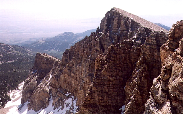
Looking at the higher summit of Baker Peak from the named summit.
Dropping to the saddle between the two Bakers (12100'), we got a nice view of the cliffs between them and Wheeler. Then we followed the ridge over the named Baker Peak (half an hour from the high point) and turned north to Wheeler, dropping to 11800' along the way. This route is also mostly talus, with some large blocks, in spite of the ranger's scary warning about it being scree and really hard to climb. They are trying to protect inexperienced tourists, and only relented when we told them we had climbed Denali together. The best footing is on or very near the ridgeline, which isn't obvious on the way up.
Wheeler Peak (the high point of Great Basin and the Snake Range at 13063') is sort of just another bump on the ridge. The USGS renamed Wheeler from Jeff Davis Peak to honor one of their own, re-assigning the original name to a forlorn secondary summit with no pleasant approaches. The summit register is in a regular USPS mailbox, which we pounded back into shape with a rock so the door would close, and it is visited VERY often. It's only a 3000' dayhike from the higher tourist trailhead (which sometimes doesn't open until mid-June, but was open on the 5th of June this year. We got there around noon, but someone had been there at 10am on the same day.
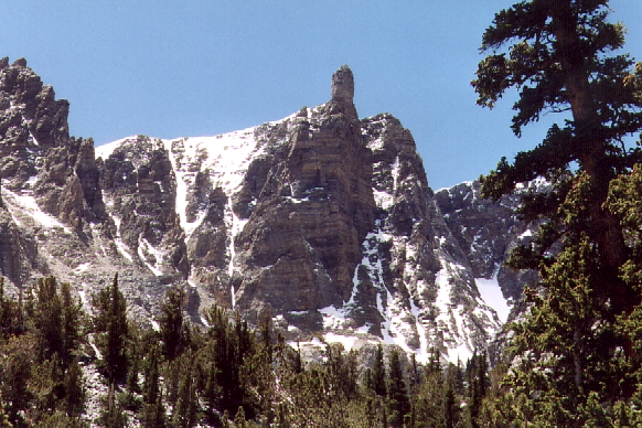
Looking at Wheeler Peak from the Bristlecone Forest (near the tourist trailhead).
After another hour on Wheeler, enjoying what we worked so hard to attain, we returned to camp in about 2.5 hours (3400' of gain and 8.5 hours so far this day). I napped to get rid of a headache while Tim raced off to climb Pyramid Peak (waypoint PYRMID, 11294') in two and a half hours round trip. Another talus/stairmaster sort of climb. We blew off the Johnson Lake loop so we could skip 700' more climbing and pack out earlier to visit the bristlecone pine forest from the tourist trailhead... and do the Lehman Cave tour.
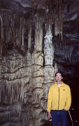
One of the large formations in Lehman Cave - smaller ones are too intricate for low-res web pics.
The Lehman Cave Tour is not to be missed. It starts from the Visitor Center - just follow the signs from SR-487 in Baker (up SR-488 past some pretty dismal looking businesses). The cave is not huge, but the quality and variety of features is amazing (and at 50 degrees inside, a welcome break from the sun on a hot day). Cheap, too, with the longest tour being well worth the extra money. Do take spare batteries for your camera, right Tim? A big flashlight will help also, as lighting is dim inside. Skip the bristlecones, the ones on White Mountain (near Bishop CA) are WAY better.
Datum,North America 1983,GRS 80,0,-1.6E-7,0,0,0
RouteName,1 ,GREAT BASIN
RoutePoint,D,BAKETH, 38.9766800404,-114.2456599474,06/12/2002,22:15:51,BAKER LAKE TRAILHEAD
RoutePoint,D,BAKESP, 38.9696899652,-114.2799799442,06/12/2002,22:15:51,SPRING AND FORK IN BAKER CREEK
RoutePoint,D,BAKELK, 38.9579000473,-114.3089200258,06/12/2002,22:15:51,CAMP AT BAKER LAKE
RoutePoint,D,BAKEHP, 38.9688199759,-114.3093500137,06/12/2002,22:15:51,BAKER PEAK HIGH POINT
RoutePoint,D,BAKERP, 38.9684000015,-114.3176100254,06/12/2002,22:32:18,BAKER NAMED PEAK
RoutePoint,D,WHEELR, 38.9860999584,-114.3132400513,06/12/2002,22:45:18,WHEELER PEAK
RoutePoint,D,PYRMID, 38.9492199421,-114.2966300249,06/12/2002,22:51:12,PYRAMID PEAK