|
Batting .500...Mt. Whitney Report and Boundary Peak SNAFU |
Saturday, 30 June 2001
This year, our highpointing
(see highpointers.org) trip would
take us west, to Mt. Whitney, the highpoint of California (and of the lower 48 states),
and to Boundary Peak, the Nevada highpoint. Flying from St. Louis to Reno was a bit
choppy but otherwise uneventful, and we drove down to Mammoth Lakes for some
acclimation.
Sunday, 1 July 2001
Sunday, we headed south from Mammoth and meandered around
the Benton Crossing Road and a bit north on CA 120 to the Forest Service roads
which lead up to Sawmill Meadows, the trailhead for Glass Mountain. Glass
Mountain is a mixed mound of obsidian and pumice which rises to about 11,000'
just to the north of Lake Crowley. A good use trail leads to its summit, but
we were running short of time that afternoon and settled for a subsidiary hump
from which to shoot a few photos and admire the view, which included our second
destination for the trip, Boundary Peak.
Boundary Peak is the second-highest peak on the horizon in the
shot below. Nearby (and taller) Mt. Montgomery is on the California side of the
line, which roughly bisects the ridgeline between Boundary and Montgomery.
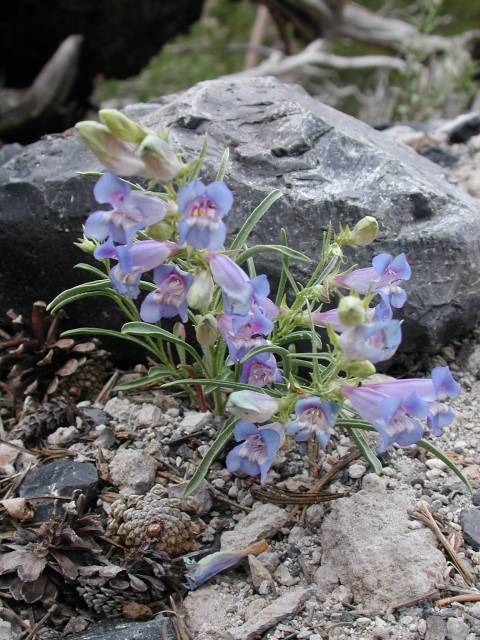
On the way down, we spotted the wildflowers in the right-hand
photo below. I'm not enough of a Sierra botanist to identify them, but anything
hardy enough to make a living on the obsidian and pumice of Glass Mountain
certainly earns my respect!
View of the upper
part of Glass Mountain, shot from a subsidiary peak.
Monday, 2 July 2001
We got up and headed south on 395 to Lone Pine, arriving
well ahead of the 10 a.m. cutoff. Picking up the Whitney Trail permit
involves the inevitable lecture about bears and trail etiquette, and it
was 11:30 by the time we made our way to Whitney Portal and started hiking.
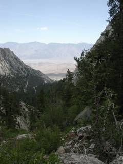
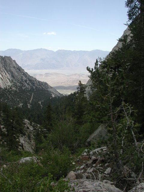
Looking back down at the valley from the trail below Outpost
camp shows that we had already gained considerable altitude by car and by
foot. As is evident from the shadows on the valley walls, the clouds were
already building over Mt. Whitney and we were pelted by rain even before we
reached Outpost Camp.
By the time we reached Outpost Camp at about 10,000', the
rain was heavy and there was a fair amount of thunder echoing around the
rock walls above us. We hunkered down at Outpost Camp for about 45 minutes,
at which point the rain began to subside and we resumed our hike in only
light showers, arriving at Trail Camp (12,000') about 6:30 that evening.
The weather cooperated with our setting up camp and cooking
dinner. With plans to get up at 4:30 a.m. the next morning, we went to bag
promptly after dinner!
Tuesday, 3 July 2001
Tuesday morning dawned with clouds on the horizon dropping virga. Not a
particularly encouraging sight, but we hastily ate breakfast and were on
the trail before 5:30. From just above Trail Camp, the vista opens up along
the ridge which runs from the Needles to Mt. Whitney, proper. We could see
what lay in store...sort of...
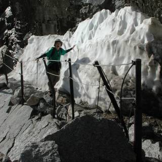
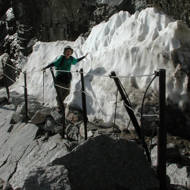
About one third through the "98 Switchbacks" section, you come to the
"Cables". This is a spot with significant exposure where the trail narrows
and hikers are protected by these cables and iron posts. There had been
considerable traffic on the
Mt. Whitney message board
the previous week about whether this stretch was "melted out" or
not. As is clear, it had melted out, if only recently. The snowbank
to Nathan's left was still across the trail through most of June, and some
people were spooked at this point and turned around. For my money, the slope
of the granite below the cables was such that a traverse on the downhill side,
hanging onto the cables, would have been quite doable. In any event, there
was a narrow but clear trail between the cables and the remaining snow, so
it was a non-issue for us.
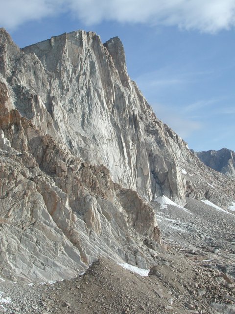
Approaching Trail Crest, the vertical extent of the east face of Mt.
Whitney is very apparent. The summit hut is not yet visible, but the
gentler western slope up toward the summit is quite apparent.
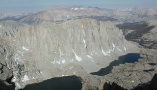
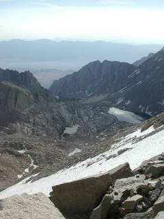
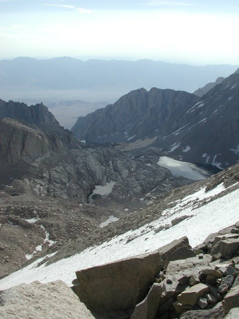
Arriving at Trail Crest (13,777'), the vista opens out to the west,
as well, where the western side of the ridge drops off to a series of
lakes and distant peaks.
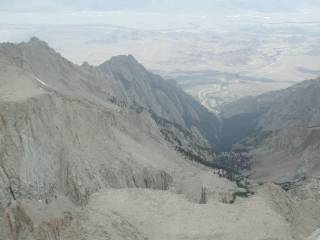
Looking back to the east, the immediate slopes up which the 98
switchbacks brought you are apparent. A bit longer view shows
the town of Lone Pine in the distance, with the valley up which the
main trail leads spread out before you.
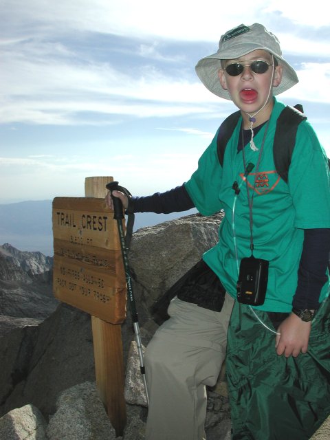
Trail Crest is marked with a sign that makes a convenient leaning
post for hikers weary of the seemingly interminable switchbacks.
The good news is, it is less than 1,000 vertical feet from here
to the summit. The bad news is, you have to go down nearly
200 feet before you start the final push to the hut, summit log and
benchmarks.
As luck would have it, I must have been suffering a bit from hypoxia, as
the only shot I took from the back side of the ridge was too blurry to
even bother with a thumbnail. I can see the summit hut, but only because
I know which blur is which. Approaching 14,000', our pace slowed considerably
and it took us the better part of two hours to go from Trail Crest to
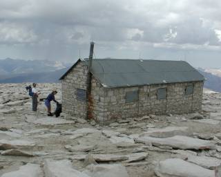
the Smithsonian hut at the summit.
36 34.721' N, 118 17.466' W, and we
arrived at the top of the forty-eight conterminous states! It had
taken from 05:30 until 10:20 to do the 4.5 miles and 2,500'. As is
evident from the clouds in both the hut photo and the shot of us,
the weather was rapidly closing in on us, so we wasted no time in
signing the summit log, taking our summit photos, and making a
360-degree panorama.
Being a state highpoint, I had to wear my Highpointers Club t-shirt, of
course! Nathan's green t-shirt is his "Class-B" (read "casual") shirt
from his Scout troop,
which he claims has now been higher than anyone
else's Class B shirt, save in an airplane. (That's a fairly safe bet,
given that the troop is based near our home in St. Louis and we're
about the only ones associated with it who are foolish enough to traipse
all the way up Mt. Whitney just to say we've been there.)
After returning to camp, the weather settled down, for a while at least.
It actually cleared off long enough that we prepared and ate dinner under
(mostly) blue skies. The calm illustrated by our campsite was to be short-lived,
however. At Trail Camp, sunset is early, but by 7 p.m., the clouds had gathered
and it once again began to rain. The rain continued fairly steadily
all night, pausing once or twice for an hour or so, and finally stopped about
7 a.m. the next morning.
Ours was a fairly typical site at Trail Camp, with a pan of packed sand surrounded
by rock wind walls erected by previous campers. A little care in selecting the
particular spot meant that our site drained away from the tent, instead of
into it. As a result, we remained dry through the night's precipitation. Others
in neighboring sites were not so lucky and spent a miserable night sleeping in
puddles.
Wednesday, July 4, 2001
Once the rain stopped, we got up, ate a quick breakfast and packed up everything
in just the state it was, wet and all. The day promised only intermittent breaks
in the weather, so we took the first opportunity to break camp and head back to
civilization. As it turned out, we managed to avoid all but a few drops of rain
on our way back to Whitney Portal, but the skies behind us quickly darkened, and
the thunder started even earlier than it had the day before. We clearly had picked
the only good day that week to summit.
Three hours later, we were happy to see that our efforts at cleaning out the car had
made it quite unappetizing to the Portal bears. The Portal store collected its due
as we bought "I climbed Mt. Whitney" shirts. Once back to Lone Pine, we stopped at
the ranger station to pick up the pewter benchmark pins to commemorate our
accomplishment. In a fit of overconfidence, I bought the benchmark pins for Boundary
Peak, as well. Having noted a Burger King in one of the towns between Lone Pine and
Mammoth, Nathan insisted on a fast food fix for lunch, and I was not inclined to
disagree.
As we drove back north, we were able to watch the development of truly spectacular
thunderstorms both over the Whitney complex and the whole span of the Sierra from
there to Mammoth. Our arrival in Mammoth was greeted by hail, lightning
and, at the motel, darkness...the power was off, and showed no signs of coming back
on in the near future.
Thursday, July 5, 2001
Thursday morning, still no power at the motel. We meandered around Mammoth, drove
up to Minaret Summit for a closer look at Mt. Ritter, and generally goofed off,
figuring we had earned a day off by virtue of our 21-mile, 12,000-gross-vertical-foot
adventure of the preceding days. Mark Wallace and his son Andrew showed up in
anticipation of the morrow's trip over to Boundary Peak.
Friday, July 6, 2001
The day dawned with mixed sun and clouds. Mark Wallace, Andrew, Alex
Sapozhnikov and Scott Benson joined us and we meandered across the back roads north
of Crowley Lake and to the thriving metropolis of Benton, California. There, we
picked up U.S. Highway 6 and crossed into Nevada. 2.5 miles west of the CA/NV
line, the ruins of Jaime's Ranch, a former house of ill repute, appeared on our
left and we turned right onto the Queen Canyon Road, intending to drive as close
as feasible to the Kennedy Point Saddle, our jumping-off point for the Boundary
Peak climb.
Hmmm...that's odd...I press on the gas, and the engine revs as if the transmission
were in neutral. No telltale signs of leaking fluid, no error messages from the
Subaru computerized transmission controller. Huh? Play with the shifter...maybe
it just popped out of gear. No such luck. Same results in any gear. Let it
sit a couple of minutes...try one more time...still no go.
We discussed the situation and options with Mark and the guys. The alternatives out here
seemed pretty bleak. The good news is, I could let the car roll to a spot in the
road where there is plenty of room for a tow truck to manuever and fetch it.
The bad news is, if we leave it there, spend Friday and Saturday climbing
Boundary Peak, Nathan and I will have no guarantee of being able to connect
with Hertz and get ourselves back to Reno in time for our late-morning flight
home on Sunday. I elect to punt. Mark ferries me back to Benton, where there
is a phone from which I call Hertz and get the retrieval/replacement wheels into
motion. We then fetch all of our gear out of the busted Subie and Mark takes
us back to Mammoth. At least I know I can get from Mammoth to Reno if I have
to, with or without a replacement car from Hertz. Mark then hightails it back
to catch up with the rest of the crew to do Boundary Peak. Mark, I owe you
big time for all of this extra driving...hope I can make it up to you some day!
About 6 p.m., a guy shows up from Hertz with a replacement Subaru. I give him
explicit directions on where to find the broken-down car and even offer
to accompany him over so he is sure to find it. He mumbles something about
having never been to this area before, but steadfastly refuses my offer to
show him the way to the car. What's that old line about hindsight being
20/20? Read on...
Saturday, July 7, 2001
8 a.m. on Saturday morning, I get a call from the Hertz office in Reno.
The genius they hired to deliver the replacement and pick up the broken car
couldn't find the car! Worse yet, he got stuck trying to do so and
had to get himself towed out! The gal from Hertz was civil but a
little cool on the phone, until I explained to her that no, the car wasn't
"off-road" and that it was left in a spot specifically chosen to make
it easy for someone to fetch it. She said that there would be someone from
Lee Vining calling me shortly to get directions on where the car was.
Sure enough, about 20 minutes later, a guy from the service station in Lee
Vining calls me. It takes all of 5 minutes to explain where the car is. As
soon as I mention "Jaime's Ranch", he knows exactly where I mean. Whew. At
least this guy is familiar with the area. One minor problem: He doesn't have
a key to the broken car. No problem. In a fit of prescience, I had kept my
key to the busted Subie since the first retriever did have the second
key from Hertz. I tell the Lee Vining towtruck guy that I'll meet him at the
diner in Benton, so Nathan and I finish packing up, check out of the motel and
head over to Benton. The tow truck driver shows up about 15 minutes after we
do. He is sure he can find the car, but this time, I'm taking no chances and
drive over to the Queen Canyon Road with him. He follows me to where the car
is, neatly turns his truck around in the 50-foot-wide graded and packed gravel
flats where we had left the car and says, more or less, "so what was the other
guy's problem?"
Then he tells me to look on the side of the road about 100 yards back as I drive
out. Sure enough, in a spot where the road was just one lane wide, with an
embankment uphill and a deep ditch downhill, there are marks where the first
retriever had given up, tried to turn around where he shouldn't have, and got
stuck. Just ahead of him as he drove in, there was a slight rise, but enough
to obscure the Subie as it was sitting forlornly waiting for help. If the
first guy had driven only 100 or 200 feet farther up the road, he
would have seen the car and had all the room in the world in which to turn around.
At least the guy from Lee Vining agreed that I was not "off road" and that
my directions had been accurate, so the failure to find the car wasn't my
fault.
As we drove back down to Benton, we could see the clouds closing down to
about 10,000' along the Boundary/Montgomery ridge. Mark and the others
certainly wouldn't be seeing much up in that soup, so maybe it was just
as well that we got shut down by car troubles.
Nathan and I stopped in Lee Vining for lunch as we drove back to Reno. As
luck would have it, we were just pulling out of the restaurant parking lot
when the towtruck pulled up with the Subie on its hook. Well, at least the
broken car was back to a main highway from where Hertz could presumeably
fetch it. By the time we got back to Reno, the gal at Hertz was gone for
the day.
Sunday, July 8, 2001
I took time Sunday morning to call Hertz and talked to the same gal there.
When I explained what had happened, she was noncommittal, but seemed not to
be inclined to press the point about having been on an improved gravel road.
(Read the fine print in a rental contract sometime. It will be enlightening!)
I told her to be sure to talk to the guy from Lee Vining if there were any
questions, since he had seen exactly what happened and would confirm that
the car was left in a spot conducive to getting a towtruck up to it.
The flights back to St. Louis was uneventful, so we arrived home in good order.
American Airlines even managed to get our luggage to St. Louis on the same plane.
One for two...batting .500, in baseball terminology. Frustrated by a broken car,
but at least we did the harder peak in good order. Having to come back
to do Boundary Peak isn't the worst thing, since I figure we'll be back to
Mammoth one of these years when Nathan decides he wants to climb our
eponymouspeak
a few miles to the west of there. Besides, it will be another good
excuse to come back out to the Sierra, which is feeling more and more like my
home away from home.
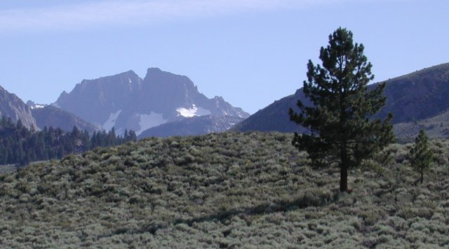
As you drive south along 395 from the intersection where 120 comes
down from Tuolomne Meadows to Lee Vining, you can just spot Mt.
Ritter and Banner Peak through a gap, just before you get to the
Shell station on the right. Mt. Ritter is about 200' taller than
Banner, but hides behind his shorter brother from this angle.
As the proverbial crow flies, Glass Mountain is only 17 or 18
miles east-northeast from Mammoth Lakes. However, road access
to the trailhead is two or three times that long, as you wander
around the north end of Lake Crowley and then up highway 120 for
a short distance to the Forest Service roads which lead to
Sawmill Meadows. The trailhead is off the last stub of a road
to the right just before you get to the Sawmill Meadows
campground, and the first time you drive there, you'll almost
certainly have to drive a quarter-mile past and backtrack to
find the right road. A copy of the 1:100,000 "Benton Range"
30x60-minute topo map will come in very handy to follow the
roads to the trailhead, and then the 1:25,000 7.5-minute "Glass
Mountain" quad will show you the details once you get there.
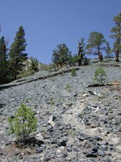
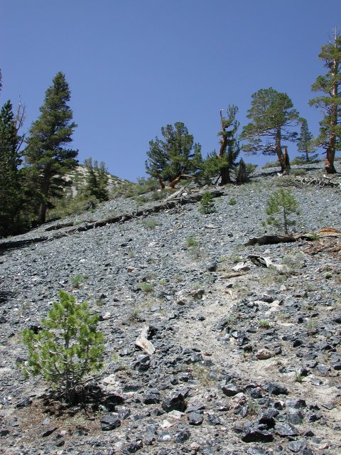
The trail is not maintained, but there is a clear use trail to
follow once the jeep trail peters out. Since we got a late start,
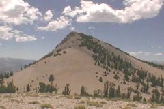
we opted out of climbing all the way to the summit and scrambled
up the pumice and obsidian to the top of a subsidiary peak from
which we could see the summit of Glass Mountain.
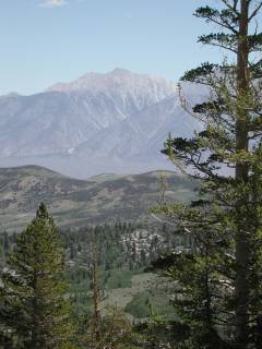
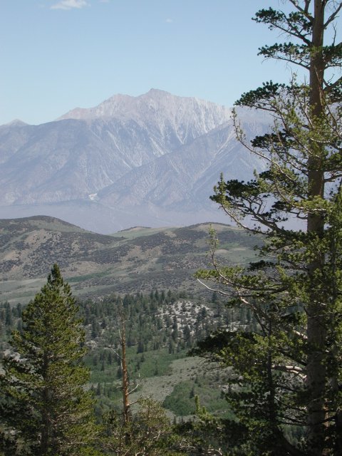
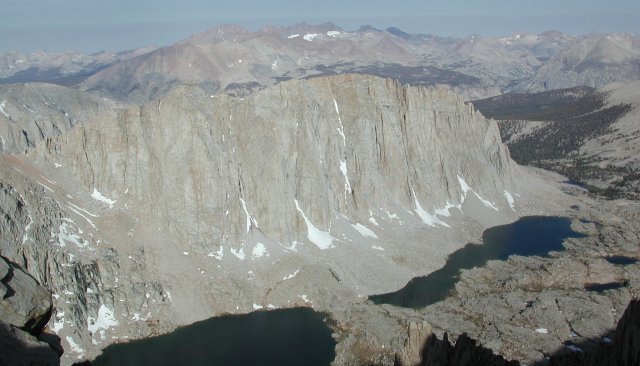
Looking east from the trail up Glass Mountain, you can see across to
Boundary Peak and Mount Montgomery. They are both part of the same
ridge complex, with Montgomery being the taller by a couple of hundred
feet. The California / Nevada state line runs through the saddle between
the two, leaving Boundary Peak the highest point in the state of Nevada.
The west face is obviously quite steep and intimidating. The usual
approaches are either up a long scree climb(?slog?) on the east side of the
ridge or from the northeast by following the ridgeline from the saddle
just below Kennedy Point and contouring around the several bumps on
the ridge between there and Boundary Peak.
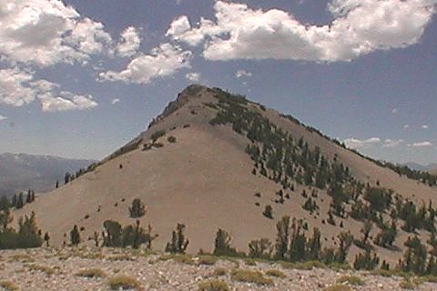
From our vantage point atop a hummock not far below the summit, we could
watch other hikers make their way up the final slope to the summit of
Glass Mountain. Running short on both time and energy, we wimped out
and called this "good enough" for our warmup hike.
I suppose someday I'll have to become more of a botanist. I have
no idea what these flowers are, but considering they grow in a
mixture of pumice and obsidian, they must certainly have impressive
root systems to survive in an area where any rain that falls
drains quickly away.
Hiking up the main Mt. Whitney trail, you can see the Alabama
Hills and the Owens Valley as you look over your shoulder.
The skies may have been clear out over the valley, but as is
evident from the shadows on the surrounding slopes, we were
headed into worsening weather as we walked west toward Mt. Whitney.
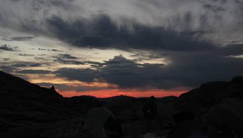
Sunrise was not particularly promising, with clouds already
gathering. Fortunately, the weather ahead of us over the
Whitney ridge looked a bit better.
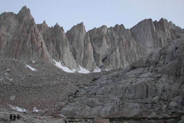
From just above Trail Camp, the ridge is spectacularly jagged,
with the Needles to the south (left) of Mt. Whitney. Whitney
iteslf is the prominent hump in the right quarter of the shot
above, with a gradual slope up from the left and a sheer drop
on its right before the jagged ridge continues farther north.
The hikers visible in the lower left corner of the frame are
about to reach the infamous "98 Switchbacks" section of the
trail, where you climb from just over 12,000' to 13,700' via a
brutal set of switchbacks. Whether the number 98 is correct
will be left as an exercise in concentration for other climbers.
The cables protect the one rather exposed stretch of the 98
switchbacks. It is a spot where acrophobes get their first
real scare of the hike, but is nothing in comparison to the
exposure at the "windows" beyond Trail Crest, nor from the
edge of the summit plateau, where 2,500' of air greets anyone
willing to "hang 10" over the boulders at the edge.
As you continue up the switchbacks, the view of the east face
of Mt. Whitney appears to the north. When you realize that it
represents 2,000' of nearly-vertical rock, you gain an appreciation
for the assessment that was made early on that it would never be
climbed. Fortunately, the western side is not nearly as steep
and presents a more reasonable approach.
The view west from Trail Crest is impressive, with much of the
Sierra spread out in front of you. Interestingly, the weather
which would threaten us shortly wasn't blowing in from the west,
but more from the south, as became apparent as we approached
the summit.
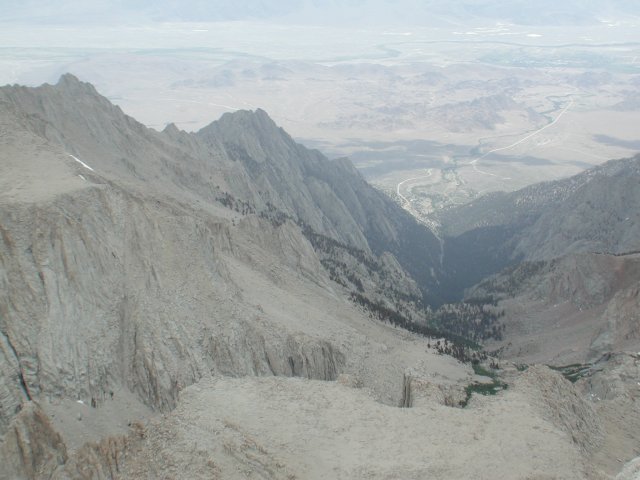
Turning 180 degrees and looking back east down the valley, you can
see all the way back to Lone Pine, although the Whitney Portal area
is hidden behind the break between the relatively shallow slopes
above Outpost Camp and the steep switchback area between there and
Whitney Portal.
As you continue up the switchbacks, the view of the east face
of Mt. Whitney appears to the north. When you realize that it
represents 2,000' of nearly-vertical rock, you gain an appreciation
for the assessment that was made early on that it would never be
climbed. Fortunately, the western side is not nearly as steep
and presents a more reasonable approach.
The sign at Trail Crest marks a good spot to stop for a few minutes
and catch whatever oxygen is available at 13,677'. Our acclimation
hike up Glass Mountain and the two nights spent at Mammoth Lakes,
plus our night at 12,000' at Trail Camp had prepared us fairly well,
but we were both a bit winded by the time we finished the switchbacks.
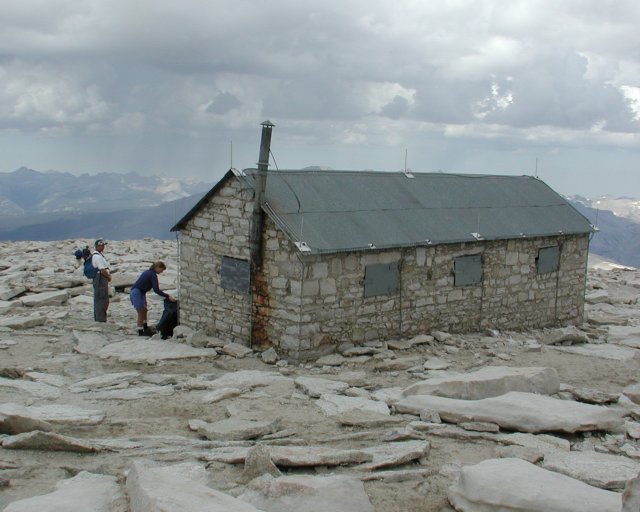
The summit hut begins to be visible about halfway between Trail Crest
and the summit, although it disappears again for a time as you get onto
the final gradual slope up to the summit. The summit log is at the back
(west) side of the hut. Despite its lightning rods and ground wires, it
is not the place to be during an electrical storm.
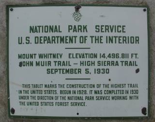
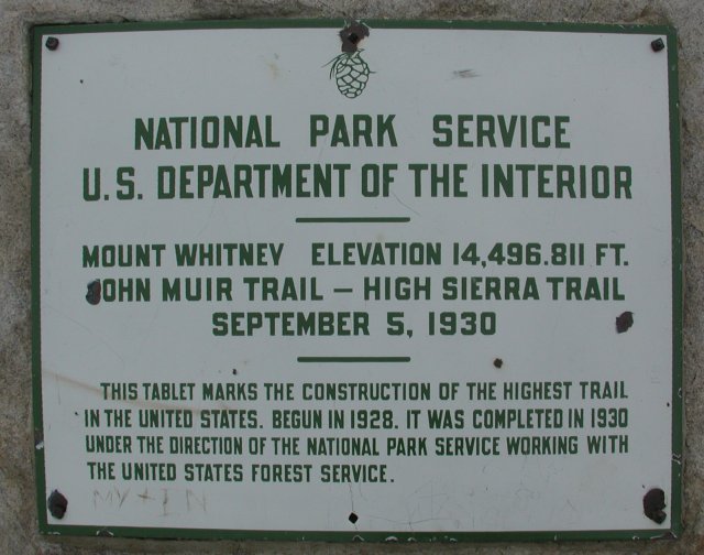
Will the real Mt. Whitney summit please stand up? The topo map
says 14,494'. This sign says 14,496.811'. The information at
the Whitney Portal Store (and their shirts) say 14,497.61'.
Either Mt. Whitney is growing, or there is a consistent upward
bias in more recent triangulation of the altitude of California's
highest point.
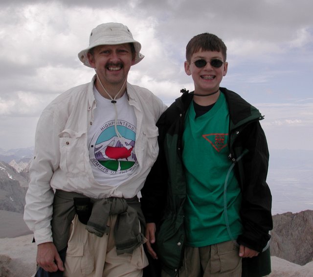
With our heads very nearly (literally) in the clouds, we stood
atop the highest point in the lower 48 states. A new personal
high for both of us, if we believe either of the two higher
measurements of the exact altitude, our heads have now been
above 14,500'. At least to become 48-state completers, everything
is downhill from here!
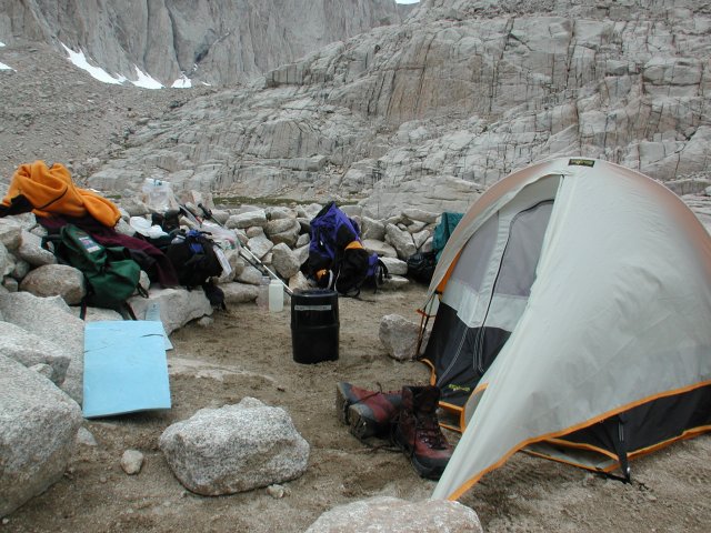
With the weather rapidly worsening, we beat a hasty retreat
back to Trail Camp. The afternoon's rain, hail and lightning
blew over for long enough to cook dinner and batten things
down for the night. This spot was typical of the Trail Camp
tent sites, with a rock wall providing some shelter from the wind
and a layer of sand and gravel hiding the worst of the underlying
rocks. Don't count on getting more than a couple of tent stakes
firmly set, though -- there weren't more than a few inches of
sand on top of those rocks, so the tent was held in place by
rocks piled on top of the stakes, instead.


We made a brief stop south of Lee Vining to take a quick look at "our" mountain. Mt.
Ritter is still there, lurking behind the slightly shorter Banner Peak and
visible if you know the right valley near the Shell station several miles
south of Lee Vining.


Mt. Ritter and Banner Peak from Highway 395, South of Lee Vining
back
Trail up Glass Mountain
back
Boundary Peak and Mount Montgomery
back
The Summit of Glass Mountain
back
Hardy Flowers, Indeed!
back
The Owens Valley from the Mt. Whitney Trail
back
Sunrise over the Owens Valley
back

The Mt. Whitney Ridge
back
The Cables
back
Looking North from the Switchbacks to the East Face of Mt. Whitney
back
Looking West from Trail Crest
back
Looking East from Trail Crest
back
Looking Back Past the Switchbacks to Trail Camp
back
Nathan taking a breather at Trail Crest
back
Mt. Whitney's Summit Hut
back
Marker at the Summit of Mt. Whitney
back
We Made It!!
back
Home Sweet Home at Trail Camp
back
To file a trip report, please fill in the Report Entry form or contact the webmaster.