6 June 1998: official PCS mountaineering trip to Baxter & Colosseum Leaders: Steve Eckert and Aaron Schuman Participants: Marcy Barnett, Mike DeLorenzo, Brian Wachter
The trip REALLY started with filling out paperwork to convince the Mountaineering Oversight Committee we were qualified to lead the trip and knew how to screen people. That part is pretty easy, and other PCS leaders should not be avoiding the process. We mused as we hiked as to how a place with no trees came to be called Sawmill Pass. Not many trees along Sawmill Creek, either - the canyon is too narrow.
The hard part was the pack into camp: 5600' of gain with ice axes, crampons, and gear to camp on snow. There is good water once you get over the ridge into the main drainage, about 3 hours into a 9 hour hike at our moderate pace. We found a dry place at Sawmill Lake, but the solid snow started 9k and there were no clearings above the one we found at 10k. (Actually a lone backpacker told us about it before we got there, so we chose to go no further.)
Weather was an issue, with clouds coming and going at all hours of the day. We opted for an early (5am) start even though the plan for Saturday was just a short steep climb of Baxter. We hoped the snow would ice up overnight, allowing crampons, and we wanted to be down before the storm hit. (It turned out the storm never happened, and the sun was baking us all afternoon.) Marcy hung out in camp with blisters and either a touch of altitude sickness or allergy problems.
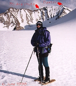
Secor mentions that the easy route on Baxter is closed due to big horn sheep restrictions. The third class face (see picture in the web version of this report) was plastered with snow, making it a 35 degree snow slope instead of loose crumbly rock. Very nice. You should definitely consider this one for early season, both to avoid the sheep closures and to avoid the rotten rock. We had some loose talus getting from the top of the snow to the ridge, and then it's good second class to the summit. The chute we picked is two gullies east of the one that Secor seems to describe (see picture in the web report). It has no headwall, it had no snow slumps, and it seemed less steep. (Call me chicken, call me safe, but don't call me a medic.)
The summit has an east, west, and south bump, and we went to them all. It's only a few minutes between them, and in the clouds we could not tell which was higher. DeLorme's software and Secor's writeup do not agree, and the topo map is inconclusive. The register was buried in snow, so doing all three seemed reasonable (just in case? hypoxia? paranoia? peakbaggeritus?).
On Baxter at 10am, we had a snack and talked about the afternoon. In the warming snow, the chute was a steep glissade and we dropped quickly to the bowl. Mike headed back to camp and the rest of us headed toward Sawmill Pass as the sun came out and slushed up the snow. I had snowshoes, but everyone else in the group had left them in the cars... making the almost flat 2+ mile walk between the peaks a knee-deep slog at times. We decided the snow chutes up through crumbly cliffs would be too soft to attack in the late afternoon, so we skirted them and ascended the west ridge of Colosseum.
Tina Stough had been there (on a day hike?) just one day earlier, so we missed being the first register signers of the year. On top at 430pm, we agreed that the ugly climb to a boring peak was OK after all, since the view toward Clarence King was spectacular from Colosseum. Do this peak with snow on it if you can. There would be a lot of sand otherwise.
We raced the sunset back to camp, ending a 15 hour day by eating in the dark and hopping into the tents just before the wind started. A little light hail overnight and much colder temperatures contrasted with the perfectly clear sky Sunday morning, but the clouds returned during our hike out and by the time we reached the cars the peaks were gone again.
One never conquers a mountain, but it's nice to be allowed a summit visit now and then. Two in one long day is more than can be asked for, especially in the company of interesting people.
PS: Mountaineers looking for a good meal on the way up are often disappointed in Bakersfield, but we discovered that the Oswell exit of highway 178 in Bakersfield (one exit east of Mt Vernon) seems to have a wide variety of restaurants: see the waypoint "FOOD" below if you have a GPS, and head southeast from the exit. You can't see any of them from the freeway, and most are not visible until you turn into the mall area.
Photo: Mount Baxter from Sawmill Pass
GPS route data suitable for transfer to your Garmin GPS follows: (see http://www.tapr.org/~kh2z/Waypoint/ for free software)
![]() Download the Waypoint+ data below as a GPX file for your GPS.
Download the Waypoint+ data below as a GPX file for your GPS.
Datum,North America 1983,GRS 80,0,-1.6E-7,0,0,0
RN,1 ,101152 TO BAXTER
RP,D,101152, 37.002977730,-121.5571547393,06/16/1998,10:13:25,HWY 101 TO HWY 1
RP,D,152005, 37.056557537,-120.9699172620,06/16/1998,10:13:25,HWY 152 TO HWY 5
RP,D,005058, 35.398973823,-119.3971878290,06/16/1998,10:13:25,HWY 5 TO HWY 58
RP,D,058178, 35.383202434,-119.0446651820,06/16/1998,10:13:25,HWY 58 TO 178
RP,D,FOOD ,  35.394081474,-118.9498920087,06/16/1998,10:14:25,OSWELL BAKERSFIELD
RP,D,178014, 35.601609350,-117.9031331185,06/16/1998,10:13:25,HWY 178 TO 14
RP,D,PORTAL, 36.605120302,-118.0630035046,06/16/1998,10:13:25,LONE PINE-395
RP,D,INDEP , 36.802874208,-118.1998873595,06/16/1998,10:13:25,INDEPENDENCE-395
RP,D,BLKRCK, 36.916902206,-118.2412321866,06/16/1998,10:13:25,395-BLACK ROCK SPR
RP,D,TINEMA, 36.917366982,-118.2558275107,06/16/1998,10:13:50,BLK RCK-TINEMAHA
RP,D,PWRHSE, 36.938486696,-118.2829875592,06/16/1998,10:13:25,DIVISION POWERHOUSE
RP,D,TRAIL , 36.939935089,-118.2901007775,06/16/1998,10:14:04,SAWMILL TRAIL
RP,D,TRLJCT, 36.921835459,-118.2976646069,06/16/1998,10:14:59,TRAIL JUNCTION 5700
RP,D,TRLPAS, 36.915398241,-118.3103405591,06/16/1998,10:15:52,TRAIL CROSSES RIDGE
RP,D,SAWMDW, 36.897797585,-118.3301676158,06/16/1998,10:13:25,SAWMILL MDW 8400
RP,D,MULE ,  36.890448333,-118.3433318976,06/16/1998,10:13:25,MULE LK OUT 9700
RP,D,SAWLAK, 36.887181402,-118.3456546906,06/16/1998,10:13:25,SAWMILL LK OUT 10000
RP,D,SAWPAS, 36.882900597,-118.3641887549,06/16/1998,10:13:25,SAWMILL PASS 11300
RP,D,COLOSM, 36.908059717,-118.3707173355,06/16/1998,10:21:26,W COLOSSEUM MTN
RP,D,BAXTER, 36.861941815,-118.3652723674,06/16/1998,10:21:19,W MT BAXTER
(watch out for line wrapping - lines above start with "RP" except "Datum" and "RN")