On July 9 I flew to Denver and drove to Boulder for a business meeting. The following Friday, July 11, I rented a four-wheel drive vehicle and drove about 250 miles south to the small resort town of Lake City, next to the Lake Fork of the Gunnison River.
At about 8 p.m. I met my two climbing buddies, Pat Ibbetson and Eddie Sudol, who had driven 1038 miles from Sacramento to meet me. They threw their gear into the Trooper and we drove west up the Henson Creek Road toward Engineer Pass. About 5.5 miles later, we turned right onto the Nellie Creek Road. The road got much rougher and for the first time I was behind the wheel in a situation in which I needed 4-wheel drive. We passed a fork in the road and came to a dead-end at a stream. Fortunately, we encountered a couple of ladies who pointed out that we had passed the fork, as we suspected. We doubled back and drove the rest of the length of Nellie Creek Road to a parking lot at the trailhead at 11,400 feet.
By 11 p.m. we had snacked and set up our bivy sites next to the truck. I broke in my new Marmot Col -20 degree bag and it was so hot that I had to poke my uncovered head out and leave the top unzipped, even though there was frost on the ground the next morning.
I slept well, but my partners did not. Pat's bag got wet during the night after it sprinkled. He was shivering and looked like sh--. I gave him my down vest and he got in the truck and vegged while Eddie and I got our stuff together. Eddie had also been cold and I was upset that he hadn't said anything, especially since I had told him that he could use my spare sleeping bag, bivy sack and/or vapor barrier, none of which I had used.
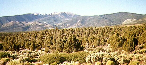
A little after 6:30 a.m. I set off alone, hiking next to beautiful Nellie Creek. Almost from the trailhead the summit of Umcompahgre was occasionally visible between the trees, just 3 trail miles and 2,900 feet ahead of me. A few hikers passed me on the way up. After a little over half a mile, the trail turned left toward the peak and crossed the stream onto a long easy switch back. We saw beautiful flowers on this hike all the way to the peak and the columbines in this section were especially fine. The columbine has five lavender petals in front of five white spurs. It is the state flower of Colorado. Many other beautiful flowers were in bloom.
Eddie and Pat caught up with me on the second switchback, where we had a great view of the southeast ridge and unclimbable 1,000 foot north face of Uncompahgre (unclimbable due to the friable rock of this volcanic plug). We continued west on easy trail toward the southeast ridge, surrounded by meadows rising over 13,000 feet. Occasionally we went over snow, but didn't need our ice axes (I used my ski pole and Pat used his ice ax as a walking stick). We walked up the windy southeast ridge, up some switchbacks onto a shoulder. After traversing a boulder field and ascending a rocky class-2 staircase, we reached the wide summit plateau, much smaller but reminiscent of Mt. Whitney's.
A few minutes later, we stood on the snow-less summit with several other folks. At 14,309 feet, this is the highest spot in the San Juan Range and the 6th highest peak in Colorado. The wind had subsided and it was so mild that I took off my shirt for a victory photo. Dozens of purple flowers were everywhere around us. A fabulous panorama of high mountains, canyons and high meadows surrounded us, with impressive peaks everywhere except to the southeast. The black mass of the Wetterhorn rose dramatically about three miles to the west. Outside the Alps, I have never seen such a classic horn. It had been our intention to hike and climb the Wetterhorn that afternoon before returning to the truck, but Eddie had a splitting headache and Pat was nervous about it. I thought that we would have to lose so much elevation and walk so far to the base that it would be better if we drove down to Henson Creek and up another drainage to get close to the peak. But I didn't know if I had enough energy to do it that day.
We hiked back the same way we came up except that occasionally I left the trail to glissade a hundred feet or more on the remaining large snow patches. The weather held and happily the fluffy high clouds refused to develop into thunder heads. I got back to the truck at 2 p.m. Pat was eating raviolis out of a can and Eddie still had his splitting headache and said he was done climbing for the day. I had some sardines out of a tin and gave Eddie my freeze-dried Mexican food.
We drove to Lake City, south on the highway for about a mile onto another dirt road, past a reservoir and up a shelf on a canyon. About 20 miles later I got very fatigued and asked Pat to drive a bit. He drove a couple of miles or so and we stopped because it appeared that a big snow patch blocked the road ahead of us. A few minutes later a jeep passed us and we saw it skirt the snow patch. So we followed it to a parking lot at the end of the road at about 11,600 feet in a place called American Basin.
At the south end of the basin are some crags much smaller than but reminiscent of the North Palisades. To the west was a long winding cascade similar to some that I had seen hiking up to Cascade Pass in Washington. This drainage was the source of the Lake Fork of the Gunnison River. High above us to the southeast was our next goal: Handies Peak, 14,048 feet. It was already past 5 p.m., so we needed to move quickly.
Pat flashed up the trail and I hiked slowly behind him, feeling very tired. Eddie changed his mind and decided to go for it. Soon they were a quarter of a mile ahead of me. I got a second wind and feeling great, I moved more quickly up the left side of the drainage on trail. The trail disappeared in the snow and I hiked east up a steep slope for a couple of hundred feet. There I saw Eddie in the lead. Pat was heading back! I asked him what he was doing and he said his feet hurt, so he was going back. I asked him if he had the car keys and he told me I had them. After I pointed out that I had given them to Eddie, he turned around and marched.
The three of us met at a sign below the steepest part of the climb, under the south ridge of Handies Peak. I led the steepest section, but soon Pat rocketed by me and Eddie passed me, thanking me for kicking Pat's a--. The trail switched back all the way to the summit. Before I got there, Pat passed my me and moved quickly down the ridge. He was anxious to get back to the car because he had not brought a light and it was already 8:00 p.m.
Eddie and I spent a few minutes on the summit, enjoying the "unparalleled 360 degree view of the heart of the San Juans." It was as if we were in the middle of an endless ocean of mountains stretching to the horizon, an illusion which I have had only there and not in the Alps or the Sierra or anywhere else. We were unable to identify any peaks except Uncompahgre. After a quick snack we left the summit and retraced our steps. Eddie was kind enough to hike with me even though he is much faster, because he didn't want us to separate as it got dark (we had only one light between us). We were off the summit ridge well before it got dark. When night came, our path was lit by a half-moon over the American crags. We didn't use our light except to flash it briefly at Pat, who briefly turned on the headlights of the truck as we walked down.
Pat slept in his tent and I loaned Eddie my Marmot sleeping back. Eddie and I bivied next to the car. We awoke to another beautiful day at about 5:30 a.m. after a clear night. Eddie had slept very well and was grateful that I let him borrow good bag. Pat was a zombie as usual. He threw his tent in the truck and crawled into his sleeping bag in the back seat.
We bounced down the road and stopped to get some water in the creek. About five miles down the road we parked at another trailhead on the opposite side of the drainage from Handies. A little before 7 a.m., Eddie and I set out east toward a pair of Fourteeners, Sunshine and Red Cloud. On the previous day, Pat had lusted for Sunshine, because it's the lowest fourteener on the planet at 14,001 feet. But today he was virtually comatose. Eddie and I hiked for a mile or two through a pine and Aspen forest and next to beautiful silver creek. I got one of my best photos of the trip looking down at Eddie next to the stream with the canyon surrounding him and Handies towering in the distance, its mass filling the "v" of the canyon.
We bumped into a couple from Boulder (originally from the Bay Area) who pointed out to us that we were only 600 feet above the trailhead and a third of the way to the top. Reluctantly, we gave up our hope of another fourteener double header, because I had to fly out of Denver that evening and Pat had to be at work by Tuesday. To reach both peaks we would have had to hike well into the afternoon. On the way down, Eddie and I spoke to a guy who had hiked up four times as fast as us, to study butterflies. He said that a rare species had been spotted in this area and he was out to count them. Just before we reached the truck at 9:30 a.m., we bumped into Pat, who had just woken up was practically running up the trail.
We drove back to Lake City had beer and pizza and departed. Pat and Eddie had the thousand mile drive back to Sacaramento by car and I had my drive back to the airport at Denver. I suggested to my buds that they visit the Black Canyon of the Gunnison National Monument and hike the (class 3!) trail down to the river and back, which would be more challenging than eithe of our two mountain climbs. It was a great weekend even though the peaks were easy, virtually all trail. On the way back, I saw several Fourteeners including the highest (Mount Elbert) and a few of the collegiate peaks.
We plan to go back next summer to do Wetterhorn (an exposed class 3 rock climb), Sneffels (a long classic snow couloir) and a couple of walk ups. For me it's five down and forty-nine to go!