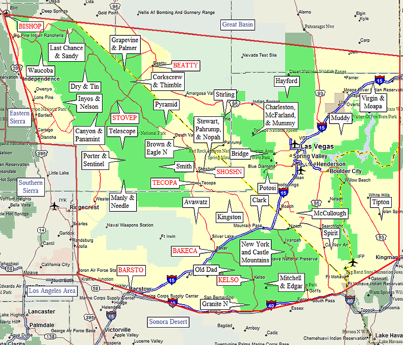
Mojave Desert Trailheads
(between Las Vegas, Bishop, Los Angeles)
Revised 3 Dec 2014 - please send updates to the webmaster
|
Mojave Desert Trailheads (click on any black label) and Towns (in red)
| ||
| waypoint | trailhead | comments |
| WAUCOP | Waucoba Mtn | on the Waucoba Saline Road, south of Death Valley Road |
| SANDTH LASTTH | Sandy Point Last Chance Mtn | just north of Death Valley |
| DRYMTH TINMTH | Dry Mtn Tin Mtn | far north end of Death Valley on the Racetrack Road |
| CERROG LONGJT UNWA2W, UNWA4W | Inyo Mountains east of Lone Pine | Cerro Gordo (for Pleasant Point, or the traverse) Long John (for New York Butte) Union Wash (for Inyo and Keynot, or the traverse) |
| NEL2WD, NEL4WD | Nelson Range | Nelson Range highpoint is east of the Inyos |
| PANATH, TOWNPS, CAN4WD EMIGTH, LEM2WD, LEM4WD | Cottonwood Mountains | Northern Panamint Range near Stovepipe Wells access to Canyon Pt, Panamint Butte, Towne Point |
| MOSAIC, SKIDOO, EMIGPS | Tucki Mountain | access to Tucki Mtn and Pinto Pk |
| MAHOGF CHRKIL | Wildrose Canyon | high point of Panamint Range access to Telescope and Wildrose |
| PLC2WD, PORTSR, COOPER, MORMON, SUR2WD, CWCAMP | Pleasant Canyon Surprise Canyon | southern Panamint Range near Ballarat access to Porter and Sentinel from either canyon |
| RUSSEL, QUAILS, NEDLTH, WILLOW | Mengel Pass | southern tip of the Panamint Range access to Needle and Manly |
| PHIN2W, PHIN4W CORKTH, CORKTS TITUSC, TTSCN1, TTNTH1 | Grapevine and Palmer Corkscrew and Thimble Titanothere and Titus Canyons | northern Death Valley (Grapevine Mountains) |
| WILLOW REDSUM | Bridge Mountain | west of Las Vegas |
| PYR2WD STEWTH PAH2WD EAGNTH BRN2WD BRN4WD SMITTH | Pyramid Peak Stewart Point Pahrump Point Eagle Mtn N Brown Peak Smith Mtn | Northern Tecopa Area between Shoshone and Death Valley |
| AVA4WD KING4W TECOPA | Avawatz Mtn Kingston Pk Tecopa Hot Springs | Southern Tecopa Area between Baker and Tecopa |
| GRANTH DAD2WD DAD4WD | Granite N Old Dad | Kelso Area: east of Barstow (Granite Mountains) |
| MITCHR GIL2WD GIL4WD STONEC | Edgar Peak Edgar/Mitchell Loop Mitchell Point | Kelso Area: east of Barstow (Providence Mountains) |
| CLKMTH NYM2WD | Clark Mtn New York Mtn | Mountain Pass Area between Barstow and Las Vegas |
| MCULTH | McCullough Mtn | south of Las Vegas, near Primm (at the CA/NV border) |
| SPIRTH | Spirit Mtn | south of Las Vegas, near Lake Mead |
| HAY2WD | Hayford Peak | north of Las Vegas, east of Charleston |
| MUDCAR | Muddy Peak | northeast of Las Vegas |
| MOAP2W MOAP4W VIRG2W VIRG4W | Moapa and Virgin Peaks | northeast of Las Vegas, halfway to Zion National Park near the Virgin River |
| TPTNTH | Mt Tipton | south of Las Vegas, near Lake Mead |
Useful Links: