Agnew Meadow, Reds Meadow, Devils Postpile
Revised 1 Dec 2015 - please send updates to the webmaster
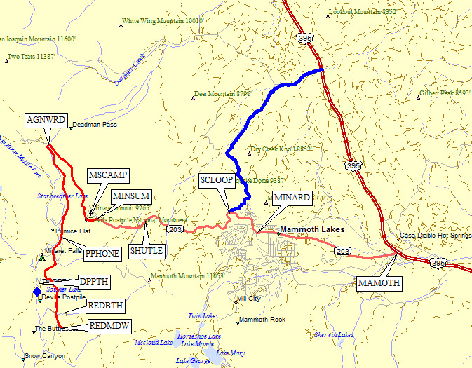
From Highway 395 outside of Mammoth Lakes (waypoint MAMOTH), take Highway 203 into the town of Mammoth Lakes. In town, consider that Schat's Bakery is open before 6am, and turn right onto Minaret Summit Road (waypoint MINARD). Proceed approximately 4.9 miles past the Mammoth Scenic Loop turnoff (waypoint SCLOOP) to Minaret Summit (waypoint MINSUM). There is an entry kiosk at MINSUM where they'll charge you to enter or exit if it's manned. This year (2004) they accept National Parks Passes but there's no guarantee that will continue.
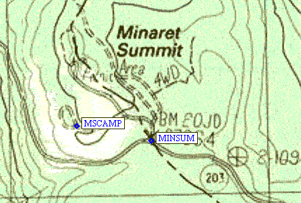
If you arrive at Minaret Summit long enough after hours (about 8pm?), you can avoid the $7.00 entry fee (2004 price, per day per person, NOT per car) AND avoid having to wait for a shuttle-bus to drive you into Devil's Postpile Monument. If you have to take the shuttle, you'll need to park BEFORE reaching Minaret Summit - near waypoint SHUTLE and below the Mammoth Mountain Inn there are "Mandatory Shuttle Parking" signs on the north side of the road. The bus is free and runs every 20-30 minutes from 7am to 730pm during summer. If you're camping for the night, turn toward Minaret Vista just before the entry fee kiosk (waypoint MINSUM) on a paved road. Take the first left onto a dirt road and you'll find a huge gravel parking area (waypoint MSCAMP) where you can apparently camp in or beside your car at an elevation of about 9200 feet. This is National Forest land so the park/monument restrictions don't apply. From Minaret Summit, proceed 2.6 miles down an increasingly narrow road to Agnew Meadows Road. If you're headed for Ediza or Thousand Island Lake, and turn right onto the "unimproved dirt" road (waypoint AGNWRD). Otherwise stay on the pavement as it widens back into two lanes and heads south to Red's Meadow where the showers and groceries and cafe are. |
Follow the directions above to waypoint AGNWRD and go north where
the paved road does a hairpin and heads south. The dirt Agnew Meadow
Road leads to Agnew Meadows Campground and the Shadow Lake/River Trail
(waypoint AGNWSR) or High Trail (waypoint AGNWHI) trailheads. There
are campsites here, including horse camps and group camps, but they
are a minimum of $16/night. This campground tends to be less full
than the others further south because there are no views and more bugs.
Climbers would be well advised to camp up on Minaret Summit (see above)
for better acclimatization and fewer mosquitoes.
This area can be confusing after dark: Go past the pack station, and
the first trailhead is what you want if you're going north on the Pacific
Crest Trail to Agnew Pass and Summit Lake. Most climbers will continue
to the SECOND trailhead, where signs say River Trail / Shadow Lake / PCT South.
In daylight the second lot will be a gravel parking loop at the edge of a meadow,
near a small stream. Some have 'stealth camped' here, but it might be best
to walk into the trees since the campground fee was $16/night and with that
kind of money at stake they may come looking for you. Both trailheads have
two-hole restrooms and working water spigots, as does the campground.
The trailhead for Shadow Lake leads to the River Trail, leaving the cars
going DOWNHILL to the south, then angling west UPCANYON to where the PCT
turns south again while the Shadow Lake trail continues northwest. There
is a trick for cutting off a bit of distance and up/down if you're clever:
Head on down the road toward the campground, do NOT go to the Group Camp,
walk past the fee board for the Horse Camp and look to the right for a
Road Closed sign in the furthest north horse campsite (waypoint AGNWHC).
Beyond the Road Closed sign a faint use trail crosses a stream and leads
west across Agnew Meadow proper to intersect a pack trail (waypoint AGNCUT)
which then intersects with the main trail. It's easy to find this route on
the way in, harder on the way out (so look backwards every so often when going
in). There are cut logs across the trail near the intersection, but in general
the trail (when returning to the trailhead) sidehills up out of the
canyon - and when it reaches the crest and is no longer on the sidehill,
look hard for trails branching left.
Follow the directions above to waypoint AGNWRD where the paved road
does a hairpin and continues south. There are several campgrounds along
this road, but they tend to be more full than Agnew Meadows because there
are better views and less bugs. Climbers would be well advised to camp up on
Minaret Summit (see above) for better acclimatization and fewer mosquitoes.
There is a public pay phone at waypoint PPHONE, across from the Pumice
Amphitheater near Pumice Flat. It's in the middle of nowhere, south of
a boarded up building, under it's own street light about 50' from the
roadside parking. Go figure.
Continue south and you'll see a total of 10 bus
stops along the pavement. The only one I'm aware of that's not on the main
road is the one at the Devil's Postpile trailhead, and all busses (up and
down the canyon) stop there. You have to flag the bus down at the other stops.
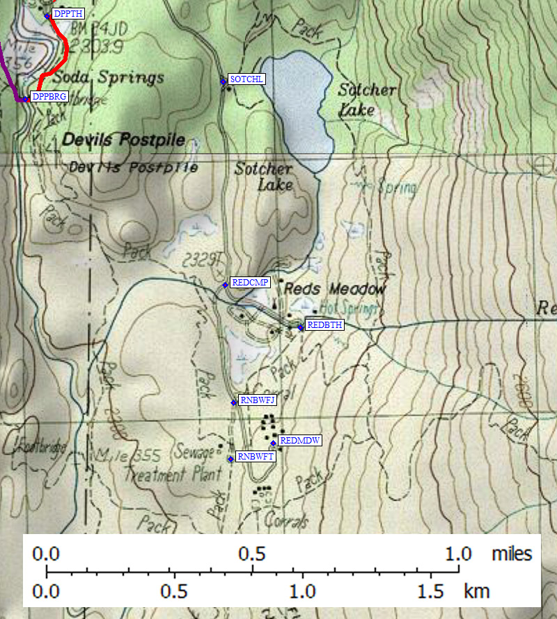
The main tourist stop for this area is at Devil's Postpile. Leave the road at
waypoint DPPJCT and go to waypoint DPPTH, where there are picnic tables and tour
busses and a ranger station with another pay phone. There is no overnight
parking near the Ranger Station, but about halfway between the main road
and the trailhead is the Beck and Fern trailhead (approximate waypoint
DPPCAR) where overnight parking is allowed.
Aside from the short hike down to see the postpile itself (hex-tube rocks),
the Devils Postpile / Soda Springs trailhead gets you to the PCT and
the JMT via a footbridge about a quarter of a mile south of the trailhead.
Past trip reports indicate this bridge is missing, but as of 2004 it's
a massive steel and wood bridge in very good shape (waypoint DPPBRG). This
is also the trailhead for Cecile Lake via Minaret Lake, Minaret Falls, etc.
Follow the directions above to waypoint AGNWRD where the paved road
does a hairpin and continues south. There are several campgrounds along
this road, but they tend to be more full than Agnew Meadows because there
are better views and less bugs. Climbers would be well advised to camp up on
Minaret Summit (see above) for better acclimatization and fewer mosquitoes.
There is a public pay phone at waypoint PPHONE, across from the Pumice
Amphitheater near Pumice Flat. It's in the middle of nowhere, south of
a boarded up building, under it's own street light about 50' from the
roadside parking. Go figure.
Continue south and you'll see a total of 10 bus
stops along the pavement. The only one I'm aware of that's not on the main
road is the one at the Devil's Postpile trailhead, and all busses (up and
down the canyon) stop there. You have to flag the bus down at the other stops.
Near Red's Meadow Resort is the turnoff to Red's Meadow Campground
(waypoint REDCMP) a dusty slum where people hang 'please drive slow'
signs and hang out next to huge camp trailers. The only reason YOU
want to be here is the FREE BATH HOUSE fed by a 103-degree hot spring
(waypoint REDBTH). Drive straight in, no turns, past the dumpsters to the
bath house parking lot. There are no lights and the private shower rooms are
very dark even during the day, but there are no specific hours so bring a
flashlight and some soap! Donations are accepted in a blue tube out front.
The Rainbow Falls trailhead (waypoints RNBWFJ and RNBWFT) is the last
turn before entering Red's Meadow Resort. The falls are nice, but not
amazing. Try to go in the afternoon, because there's no rainbow in
the morning when the falls are in the shade.
Finally, you're at Red's Meadow Resort (waypoint REDMDW) where the
both the small general store and the Mule House Cafe is open 7am to
7pm during the summer. Another pay phone is between the diner and
the store. Grab a beer at the store before dinner since the cafe
has no liquor license. You can rent a horse or a cabin here (call
760-934-2345) and I think they'll store things and accept food
shipments for through hikers on the PCT and JMT.
Useful Links:
Agnew Meadows Trailheads - GPS Route AGNEW MEADOW
(Shadow Lake Trail, River Trail, High Trail)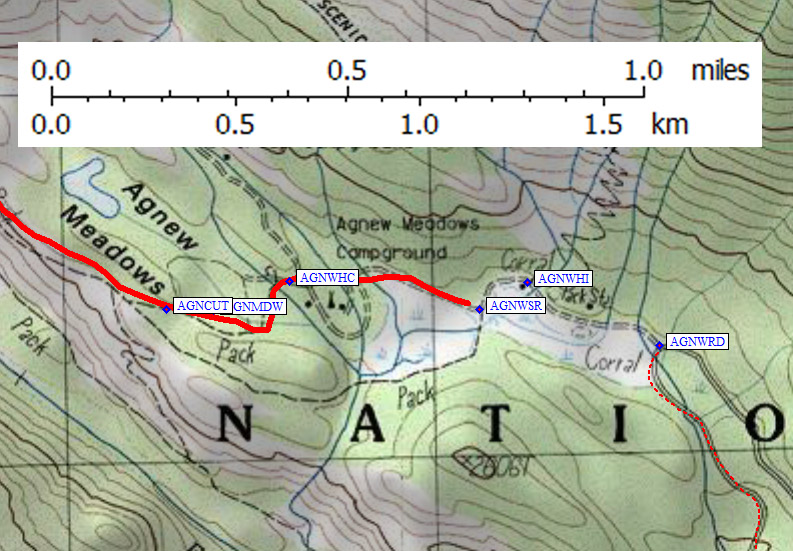
Devil's Postpile Trailhead - GPS Route DEVILS POSTPILE
(Minaret Lake, Minaret Falls)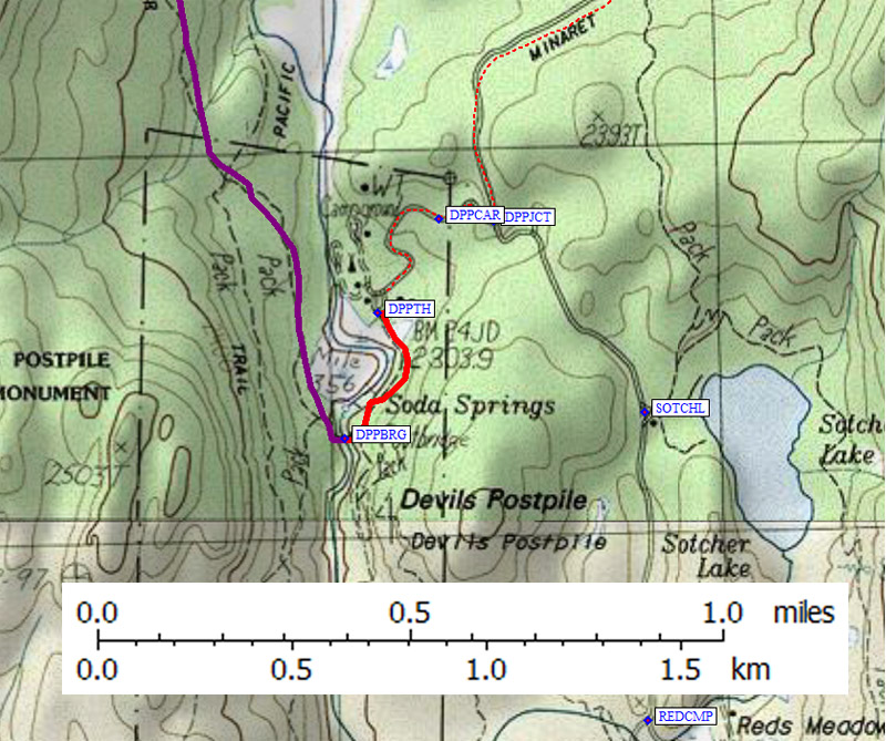
Red's Meadows Trailhead - GPS Route REDS MEADOW
(Rainbow Falls, Pack Station, Cafe, Showers)