Bear Box at Merced Lake (YV05)
Generated on 2 Aug 2022 - see revision history - please send updates to the webmaster
Detail Map of waypoint YV05
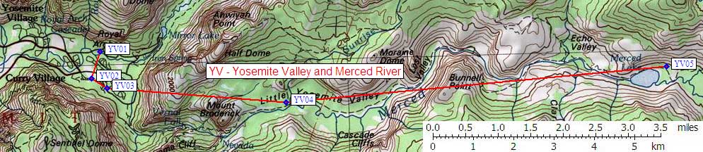
in Yosemite Valley and Merced River:
(scroll down for directions, waypoints, and area map)
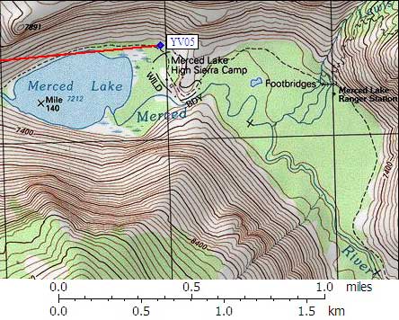
- YV05 is 4 standard plus 4 large boxes, at about 7200 feet,
in the GPS route YOSEMITE VALLEY.
- Note: The Merced Lake Backpacker Campground is about 200 yards
east of the northeast corner of Merced Lake, where the trail
turns south around a shoulder. The High Sierra Camp, with
it's tourist crowd and horses and dinner bells, is partially
visible from the campground, but the backpacker camp is in
tall trees and has a spigot supplying potable water and a
flush toilet in a brick building (so it feels like car camping).
Some people get water and store their food here, but camp to
the west so they can avoid crowds and campfires.
- Directions from Steve Eckert, verified GPS waypoint, Sep 2002:
Four large boxes and four standard boxes are on the
north side of the trail just as you reach the backpacker
campsites. The provided GPS waypoint is near the water
spigot, and is closer to the trail than either set of boxes.
The standard size boxes are about 30 yards northeast of the trail,
beyond the water spigot. The larger boxes are about
30 yards west of the standard boxes (NW from the spigot).
- Directions from Kalon Kelley, with GPS waypoint, Sep 1999:
Four bear boxes in the middle of the backpackers
campground to the north of the High Sierra Camp.
- YV05 coordinates: (see GPX waypoint download links above)
  (lat,lon) = (37.7406100, -119.4073200) in decimal degrees, NAD83.
  (zone,east,north) = (11S, 287964.0, 4179565.0) in decimal meters, NAD27.
- Scroll down for a regional map of the entire Yosemite Valley and Merced River region.
Map exported from TOPO! software, used with permission.
Useful Links: