Bear Box at Little Yosemite Valley (YV04)
Generated on 2 Aug 2022 - see revision history - please send updates to the webmaster
Detail Map of waypoint YV04
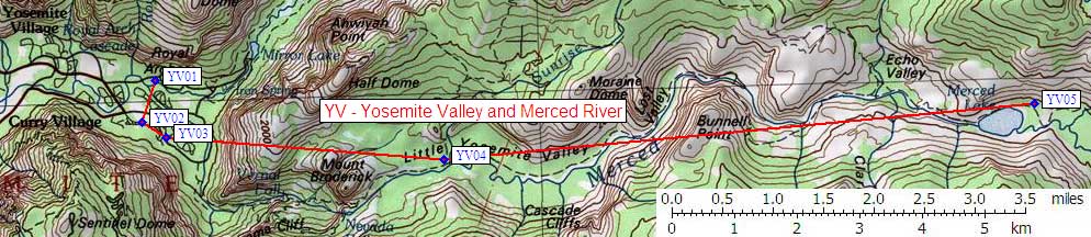
in Yosemite Valley and Merced River:
(scroll down for directions, waypoints, and area map)
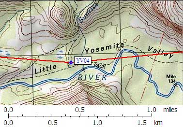
- YV04 is 6+ standard boxes, at about 6100 feet,
in the GPS route YOSEMITE VALLEY.
- Note: The Little Yosemite Backpacker Campground is just upcanyon
(northeast) from the trail junction marked 'Half Dome' or
'Merced Lake' - which is less than a tenth of a mile west of
where Sunrise Creek joins the Merced River. The map shows
several trail junctions, but you'll know you're at the
correct one when you see a brick outhouse to the north.
Between the junction and the outhouse, go east to find
various campsites in the trees.
- Directions from Steve Eckert, with GPS waypoint, Sep 2002:
The provided GPS waypoint
is for the westernmost (downcanyon) of the boxes which are
spread out among the campsites and are in trees too thick
to get a good GPS waypoint. The westernmost box is roughly
100 yards toward the Merced River from the brick outhouse.
- Directions from Mark Connell, June 2000:
There are at least half a dozen standard bear boxes at Little Yosemite.
They were all pretty full when I was there last fall,
with several people walking around trying to find space in boxes.
- Directions from Kalon Kelley, Sep 1999:
There are some bearboxes in the backpackers campground at Little Yosemite Valley.
- YV04 coordinates: (see GPX waypoint download links above)
  (lat,lon) = (37.7324200, -119.5152000) in decimal degrees, NAD83.
  (zone,east,north) = (11S, 278433.0, 4178906.0) in decimal meters, NAD27.
- Scroll down for a regional map of the entire Yosemite Valley and Merced River region.
Map exported from TOPO! software, used with permission.
Useful Links: