
(Map exported from TOPO! software, used with permission.)
View all boxes in this region overlaid with roads and trails on satellite images or maps
using Google Maps (web application) or Google Earth (must download and install).
(Click on any icon to get details in a popup, double-left-click to zoom in, double-right-click to zoom out.)
| Bear Boxes in
Woods Creek
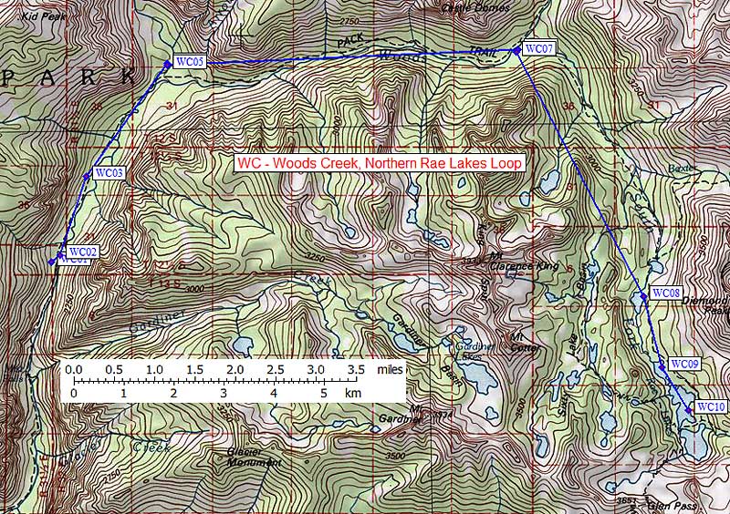
, Northern Rae Lakes Loop Previous region is TC. Next region is YE. | |||
| click on box name for details and written directions | elevation | waypoint | food locker type |
| Lower Paradise West | 6600 | WC01 | a standard box |
| Lower Paradise East | 6600 | WC02 | a standard box |
| Middle Paradise | 6700 | WC03 | a standard box |
| Upper Paradise North | 6900 | WC04 | a standard box |
| Upper Paradise South | 6900 | WC05 | a large box |
| Woods Crossing North | 8500 | WC06 | a standard box |
| Woods Crossing South | 8500 | WC07 | a standard box |
| Arrowhead Lake | 10300 | WC08 | a standard box |
| Lower Rae Lake | 10600 | WC09 | a standard box |
| Middle Rae Lake | 10600 | WC10 | 2 standard boxes |
Note that each waypoint name contains the 2-letter region code and the box number so you can strip out the RouteName lines and still know which box is which. Route names and waypoint comments are limited to 16 upper-case characters for Garmin compatibility. The comment field contains a shortened bear box name which will be close but not exactly the same as in the alphabetic listing names. Use the 4-character waypoint name as a cross reference with other pages.
Datum,North America 1983,GRS 80,0,-1.6E-7,0,0,0 RouteName,22,WOODS CREEK RoutePoint,D,WC01,36.8337300,-118.5431600,06/21/2008,19:34:42,LOWERPARADISEW RoutePoint,D,WC02,36.8349500,-118.5411400,06/21/2008,19:34:42,LOWERPARADISEE RoutePoint,D,WC03,36.8493200,-118.5353600,06/21/2008,19:34:42,MIDDLE PARADISE RoutePoint,D,WC04,36.8699000,-118.5171500,06/21/2008,19:34:42,UPPERPARADISEN RoutePoint,D,WC05,36.8696000,-118.5170300,06/21/2008,19:34:42,UPPERPARADISES RoutePoint,D,WC06,36.8724700,-118.4378200,06/21/2008,19:34:42,WOODSCROSSINGN RoutePoint,D,WC07,36.8718800,-118.4382600,06/21/2008,19:34:42,WOODSCROSSINGS RoutePoint,D,WC08,36.8275500,-118.4096000,06/21/2008,19:34:42,ARROWHEAD LAKE RoutePoint,D,WC09,36.8147100,-118.4053500,06/21/2008,19:34:42,LOWER RAE LAKE RoutePoint,D,WC10,36.8068800,-118.3994300,06/21/2008,19:34:42,MIDDLE RAE LAKE
Datum,North America 1927 mean,Clarke 1866 ,-69.4,-0.37264639,-8,160,176 RouteName,22,WOODS CREEK RoutePoint,UTM,WC01,11S,362472.8,4077340.0,06/21/2008,19:34:42,LOWERPARADISEW RoutePoint,UTM,WC02,11S,362655.0,4077474.0,06/21/2008,19:34:42,LOWERPARADISEE RoutePoint,UTM,WC03,11S,363196.0,4079060.0,06/21/2008,19:34:42,MIDDLE PARADISE RoutePoint,UTM,WC04,11S,364856.0,4081317.0,06/21/2008,19:34:42,UPPERPARADISEN RoutePoint,UTM,WC05,11S,364866.0,4081283.0,06/21/2008,19:34:42,UPPERPARADISES RoutePoint,UTM,WC06,11S,371931.0,4081493.0,06/21/2008,19:34:42,WOODSCROSSINGN RoutePoint,UTM,WC07,11S,371891.0,4081428.0,06/21/2008,19:34:42,WOODSCROSSINGS RoutePoint,UTM,WC08,11S,374373.0,4076472.0,06/21/2008,19:34:42,ARROWHEAD LAKE RoutePoint,UTM,WC09,11S,374731.0,4075042.0,06/21/2008,19:34:42,LOWER RAE LAKE RoutePoint,UTM,WC10,11S,375246.0,4074166.0,06/21/2008,19:34:42,MIDDLE RAE LAKE

Map exported from TOPO! software, used with permission.