NOTE: The report which follows is heavily biased toward route and waypoint descriptions, because we spent a lot of time wondering if we were on route, because others keep getting lost there, and because help is so very far away.
The high point of Baja, Mexico, is El Picacho del Diablo (for the non-Spanish-speaking crowd, that would be "Devil's Peak"). Linda Roman had been denied the summit twice before, once by roads and once by ice, so when she convinced John Strauch (another ice-bound veteran) to try again and asked me to go along I had some misgivings. Was it too soon and still snowy? Was it too late and baking hot? The last time I was in Mexico involved gunfire on two occasions, but I put all that aside and packed for all reasonable conditions except ice. Phil Rogul joined us at the last minute, and we left from San Diego on 12 May 2001 for our Roman Holiday (the trip that went to the devil... on purpose).
It takes the better part of a day to drive to the trailhead in Parque Nacional San Pedro Martir, mostly because there are over 100km of dirt roads. We chose the west side entry because of its relative safety and because the trailhead is higher altitude. Somehow I skipped over the fact that the backpack in went up 1000' and then DOWN 3000', leaving us with quite a haul back out, but I still think this was a fine approach. Whether you enter from the east or the west, the summit day from Campo Noche is 3800' of gain in 1.23 miles, or an average slope of 60% - twice the "angle of repose" for many mountains, and much of it involves ducking under tree limbs and climbing over boulders.
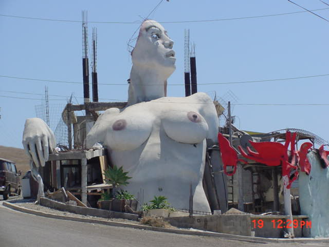
Watch for the large house shaped and painted like a
naked woman near the 50km mark on Hwy 1 (waypoint WOMAN) and do
shield the children's eyes if you worry about that sort of thing!
I caught a glimpse of it when heading down to climb Picacho del Diablo,
and this photo proves I'm not crazy. The house owner may be, but not me!
|
Click on either of these small maps to pop up a PDF map which
you can scale to view or print with good resolution.
Both driving and hiking waypoints are listed below,
with a link to an interactive map of all the waypoints.
.
| |
|
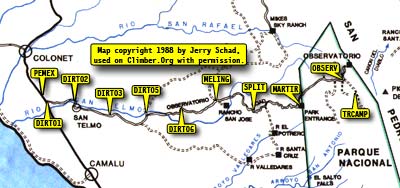
This report refers often to waypoints plotted on a scanned image of
Schad's map (used with permission from Jerry Schad). The hardcopy map
Parque Nacional San Pedro Martir (San Pedro Martir National Park)
including Picacho del Diablo by Jerry Schad, published by Centra
Publications, is a must-have. It contains topographic data, route
summaries, and background information on the park.
|
|
There are waypoints at the border, several in Ensenada in case you get lost, and one at the last possible gas station (waypoint PEMEX is just north of the turnoff to the national park, waypoint DIRT01 is where you actually leave the pavement). A string of waypoints lead you along the good dirt road, which climbs to 2000' (waypoint DIRT06) before getting rough. Strauch's Hyundai sedan bounded along on its tiny tires all the way to the trailhead with no apparent damage.
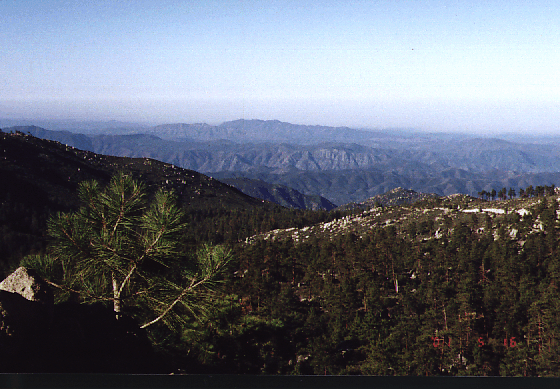
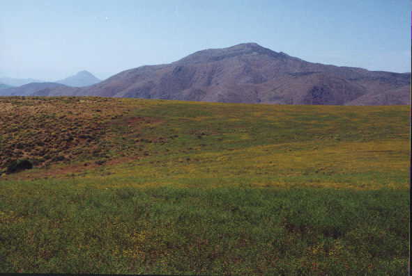
We had expansive views west to the Pacific Ocean
while driving toward Parque Nacional San Pedro Martir
The first real junction on the dirt road is at waypoint MELING, where you turn toward Rancho Meling (stay on the main road, don't turn into the ranch). Waypoints SPLIT1 and SPLIT2 are near confusing places that you can ignore: The road forks, but both forks come together shortly so take whichever one you want.
Waypoint MARTIR is the entrance to the San Pedro Martir national park. The buildings were deserted but the gate was open. We stopped to look around, and heard a hissing tire on Roman's Jeep. It was flat in about 2 minutes, but we attacked it like a pit crew and moved on. The plateau of Sierra San Pedro Martir is about 8000', and seemed oddly void of brush and wildlife. Lots of tall pine and aspen trees growing in sand, but very dry in spite of a reported 24" per year rainfall. Waypoint OBSERV is where we turned off the main road (to the observatory) with a sharp right turn onto a road marked Botella Azul (toward the Blue Bottle trail). Don't stop at the building, keep going in the same direction to waypoint TRCAMP where you'll find a log teepee frame (some call it a pyramid) and a loop road along which you can car camp. It was just below freezing at night, but soon after sunrise we were in shorts.
Surprising field of wildflowers around 2000-3000' elevation
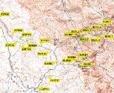
If you see a "hikers only" sign (a hiker symbol and the word "solo") you've gone just a few yards too far. Continuing up that road will lead you to "the shack" at Los Llanitos, where old reports indicate you can park. The road is now closed, and you should NOT start in that direction. From waypoint TRCAMP, where we both parked and camped, you should head directly up the shallow drainage (at a bearing of 95 degrees from the cars) to waypoint ASPEN1 where a clear streambed forms and a trail shows up on the south bank. Follow the trail or tromp up the wash to waypoint ASPEN2, where you can turn left into the mouth of what looks like a poor choice of small washes (but actually is correct) or continue up the main drainage to waypoint ASPENA.
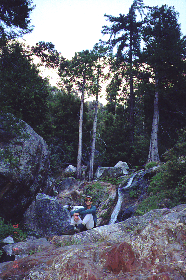
Walking through the Aspen Grove - Strauch/Rogul/Eckert from left to right

On the way in, we missed the correct trail entirely and followed the main drainage through Aspen Grove (waypoints ASPENA and ASPENB are two places where we hunted around a bit for a good route, and were tempted to follow ducks out of the drainage). On the way out we picked up the trail shown on Schad's map, going via waypoint ASPEN3 and bypassing the main aspen groves. This saved a bit of distance at the expense of some up and down, and the trail is easier walking that the wash. Either way there is year-round water available so you can leave the vehicles with minimal weight. The scenery is so different on the two routes that I'd highly recommend taking them both!
The place where you leave the wash to stay on the shorter trail (ASPEN2) is hard to spot on the way in. I'd tell you to look for ducks (from one balanced rock to large cairns), but as another report once said, don't take comfort in seeing ducks because even the wrong routes are marked. It's a hard left turn just as you're sure you can see the wash curving left in a broad arc in front of you, and the trail seems blocked by huge boulders that represent the only real obstacle to an otherwise excellent trail. Go between the boulders and follow an obvious trail.
If you elect to stay in the wash, you will want to stay right when the drainage forks. We picked up a good use trail and wound up sidehilling with easy footing over 100' above the canyon floor. When returning, we took an equally good trail that stays right beside the year-round running water. Neither trail seems visible from the other, but both are in the canyon marked with waypoint ASPEN5. From here you follow the canyon (east) as it bends right (southeast) and climbs through great terrain to a broad saddle (waypoint ASPEN6). Leave the saddle at a bearing of 148 degrees and traverse over a small ridge, sidehilling slightly down until you see a major canyon opening to your left.
Turn east (uphill) into the canyon which starts at waypoint BLUEB1. This is where the trail from "the shack" intersects the trail you are on... but neither trail is really more than a ducked route. For completeness, I've included Cheslick's waypoints for the route from the shack at Los Llanitos (waypoints LLNTS1 and LLNTS2) to the "junction" at BLUEB1, but I have not field checked them and you should review my notes on datum problems below! (If you can't drive to the shack, there is no reason at all to walk there.) Stay on the left (north) side of the canyon as you approach the slabs that appear to block your route, then zigzag through them to the left and pop out at "Blue Bottle Saddle" (waypoint BLUEB2, northwest of Cerro Botella Azul) where you can see the peak(s) and the observatory for the first time.
At our leisurely pace, we didn't reach this saddle (at about 9300') until noon. Waypoints from Cheslick's report didn't match very well, and a side trip to climb Cerro Botella Azul (Blue Bottle Peak, the second-highest peak in Baja at 2950m or 9680', waypoint CBAZUL) confirmed the problem: He reported coordinates in UTM grids, but didn't specify the datum. I assumed NAD27 CONUS, which most UTM people prefer, but that caused over a tenth of a mile error. Assuming NAD84 resulted in a closer match, but perhaps they are in NAD27 MEXICO or some other coordinate system. Either way, don't trust any GPS coordinates if you don't get a datum spec with them, and make sure to enter them only after setting your GPS to the matching datum.
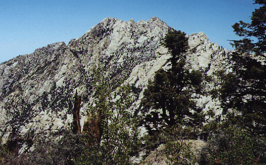
The west side of El Picacho del Diablo from Blue Bottle Saddle
(the north, higher, peak is on the left)
The wrecked transmitter on Blue Bottle was an eyesore, but there is a register and a small (blue) bottle of Vick's Vapo-Rub. Hmmm. I wonder if the name or this bottle came first? We spent most of our time looking at the amazing view (north) down into Campo Noche (our first day's destination), up northeast) to the summit, and west over the plateau. Salt water could be seen both east and west, a sharp contrast with the desert and our tree-studded peak and a reminder of where we were (Baja California).
Then we started down. The map shows a trail junction right at the saddle, but as you head east there are ducks and apparent trails everywhere. Ignore them. Keep traversing, slowly losing altitude. Even when it looks like it's going to get steep and you should go down NOW, keep going until waypoint BLUEB3 (at about 9100') or you risk getting trapped in Gorin's Gulch with Class 5 rappels. Once you DO start going down, still going east, following ribbons or ducks becomes unnecessary because you traverse a cliff on the only route possible. The crux is about 8900' where you are on a narrow rubble-covered ledge with high exposure in a small stand of aspens. Below the traverse (at waypoint BLUEB4, about 8700') where the trail pops over a low rib, you should try VERY HARD to stay on the use trail switchbacks. They drop you 1000' (going north) before any scrambling is required, but on the way in we didn't stay on them and burned up our knees for nothing.
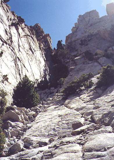
Around 7700' the canyon gets serious and you'll have to pick your route carefully to avoid 3rd class climbing at various dry waterfalls and cliff bands. The route stays on the left (west) side of the wash for the most part, but crosses occasionally. Here the ducks become positively annoying, because some of them are in places you can't get to and don't want to go. We found the red surveyor's tape more reliable than the cairns, but there are large gaps where no marks are to be found. Don't worry about it... just stay in the drainage until year-round water shows up again. I believe Gorin's Gulch joins the drainage we followed at a beautiful waterfall on the left (west) side of the canyon. From here to Camp Noche the going is particularly tough. Crawling under trees and through brush is bad enough even when your knees haven't been pounded with thousands of feet of cross country downhill with a full pack!
The waterfall which comes out of Gorin's Gulch
Water sounds good when you've been dry all day, but with it came stinging nettles and gnats and a few mosquitoes, plus the need to fight through brush to avoid the slick rock and pools. I enjoyed this part a LOT more on the way out, in the morning when it was cooler and bug-free. Campo Noche ("Night Camp", waypoint BPCAMP at 6300', the backpackers campsite for both the east entry and the west entry) is impossible to miss. It's on the right (east) side of the drainage as you come to the second major side canyon. Boulder Wash was the first (where the canyon is not as steep), Night Wash is the second (just after the canyon steepens again). A small but deep swimming hole marks the start of the campsites, some of which are hidden about 50' elevation up the side of the canyon from the obvious ones near the stream. My altimeter showed 1800' of gain and 3300' of loss (including the peak) getting to camp, which took us 10 hours total at a moderate pace with lots of long breaks.
My pre-dawn morning chant was the agreed way to get awake, Rogul's standard "So what does everyone want to do today?" question was the best way to get moving, and we left camp around 6am after a very warm (45F) night. We departed from the middle campsite, but should have left from the upstream one (via the hidden camp area) and should have on the right (south) side of Night Wash near the bottom. Those who advise staying in the center of the wash are right once you're a couple hundred feet above camp (where the brush eases off), but that's not the best way to get started (as we learned when returning).
Since we were in such a deep canyon with very tall trees, the waypoint for Campo Noche (BPCAMP) may not be accurate. About 600' up Night Wash (at 6900') I stored waypoint DEVIL1 where camp was at a bearing of about 260 degrees. The waypoints are at an angle of 266, indicating that one or both of them may be off due to the narrow steep canyon and tree cover. While you are actually in Canyon del Diablo it is probably best to use terrain recognition and an altimeter instead of GPS coordinates.
We drifted left (north) as we climbed, and waypoint DEVIL2 is on top of a minor ridge that comes into the drainage we were climbing. I do not recommend going that way, since the use trail we took on the way down stays in the center of the drainage at that elevation and was more brush-free. Routes abound, none is perfect. The plants slowly change as you climb, and odd rock formations make the climb interesting.
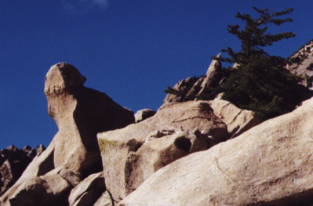
Odd rock formation in Night Wash or Slot Wash
We crossed another subsidiary ridge, also entering our drainage from the left (north), and entered what appeared to be a large bowl. Waypoint DEVIL3 is at a constriction in the bowl, where we stayed to the left. We stayed high on the left for a while but returned to the center of the canyon around 7800'.
Drifting right, we stayed out of the center until we came to a bigger knob or face (near waypoint DEVIL4, apparently the entrance to Slot Wash) and traversed sharply to the left about 100' below the base of the face into the canyon leading to Wall Street. Here at 8200-8500' elevation we repeatedly found what looks like year-round water (based on the presence of thirsty plants like columbine) in Slot Wash, matching the information on Schad's map, and wished we had not carried all our water up from camp at 6300'. In this area the route appears to enter and exit the wash to avoid waterfalls and slick rock, so be prepared to climb out on the left (north) and return to the stream several times. Just above 8400' the cliffs force you back into the stream for a very short distance, then a waterfall forces you back out near 8500'. On the way down this was the only place we had to hunt for a route, so pay attention here!
At waypoint DEVIL5 (8800') we traversed left out of the wash and onto the steeper of two friction slopes. This one I measured at 40 a degree slope, the upper one was probably more like 30 degrees. Going straight up would have led us into loose talus, so the point at which you should traverse is easy to find. By this point I had counted 8 hummingbirds on the route. I wonder if they thought we were food? Above the slabs (which were steep enough to give us pause, but easy to work around on cracks and seams) we did some more boulders and entered a canyon which formed to our left. Almost at the entrance to this new canyon we traversed right onto lower angle friction slabs and headed into a narrow square-bottom chute with a headwall that required class 3 climbing on a ledge to the right. This narrow chute (waypoint DEVIL6) is the entrance to Wall Street, and the climbing stays steep but mostly class 2 from here to the ridge (with a few loose boulders here and there).
Slabs at the entrance to Wall Street, below the square 3rd class chute
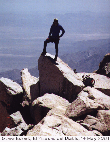
Wall Street tops out just a few feet from the summit, an easy class 3 scramble to the left. We hit the summit just after 11am, the moderate pace and early morning shade allowing us to reach the north peak of El Picacho del Diablo (waypoint DIABLO, at 3095m or 10154') without being exhausted or overheated. We stayed well over an hour, savoring the view and the mild temperatures, napping, taking hero shots with the low desert or the south summit (2 feet lower at the far end of a 4th-class-looking traverse) in the background. The register is full but only one year old, so we signed in on the edge of the page and left a Climber.Org business card! If you're headed up there soon, ask yourself why the locals climb in April and the tourists climb in May... but take a register book anyway!
This is actually about 50 yards from the summit, on a more
impressive rock near where Wall Street hits the summit ridge
Returning to camp we followed different routes in places, and took several long breaks. We lost the route only once, at about 8500', but recovered in a few minutes after giving up on our memory and just going where a route seemed like it would work (back into the center of drainage, as described above). All possible directions are marked except when you're not sure where to go, in which case there are no ducks or surveyor's tape at all. Including our long lunch on the summit and a couple of half hour stops on the way down, we were away from camp 12 hours with about 4000' of gain/loss. We all agreed that the stops were preferable to arriving in camp early, because there was a mild breeze in Night Wash compared to the still air and bugs at Campo Noche.
The 10-hour hike out was uneventful, for the most part, but the route diverged from the hike in as noted above. Roman stepped on a moving rock heading down from Blue Bottle Saddle and did a mid-air-face-plant somersault over a small tree/boulder combo that could have done some damage. She was fortunate enough to walk away unscathed. The only damage was some leaves stuck to her face - a testament to her reflexes and plain old good luck, and much better than the twisted neck or shoulder I thought she might have as I watched her go down.
We had good debates, long breaks, a moderate pace, and no drive home that night! We tossed back a few beers, built a fire, and talked about life until the stars ruled the night. I feel fortunate to have been invited with this group, and hope my report will help others enjoy it as we did. Too many reports speak of injuries (perhaps because people were rushing or off course) and split up groups (which reduces safety margins in a place where help is NOT close at hand). We stayed together, we stayed happy (except when the gnats got to me), we stayed basically on route and on schedule, everyone helped out, no one was injured beyond brush scratches, we never wanted the emergency rope I brought, and we all got the peak. Who could ask for anything more?
Other reports may help also:
Waypoints below are as logged on my GPS (after "selective availability"
was turned off by the US Government so they should be accurate). I use
NAD83 CONUS for waypoints, and as long as you enter them into your GPS
using that datum you can switch to any other datum for use in the field.
You may wish to use data from the map instead, but either way don't
follow instruments blindly. There is a discussion of UTM vs. degree
specifications and datums, along with links to several software packages
(both free and commercial) that can convert between them, on the
Sierra Peaks database page.
NOTE: The interactive map link below defaults to an overlay only usable
in the USA. Pull down the upper right menu and choose 'Terrain' to get
Google Maps topo lines. See also the static PDF maps above.
Waypoints
![]() Download the Waypoint+ data below as a GPX file for your GPS.
Download the Waypoint+ data below as a GPX file for your GPS.
Datum,North America 1983,GRS 80,0,-1.6E-7,0,0,0
RouteName,2 ,DRIVING
RoutePoint,D,BORDER, 32.5352300056,-117.0295599738,05/17/2001,23:49:31,BORDER CROSSING
RoutePoint,D,WOMAN,  32.2440500104,-116.9329799823,05/17/2001,23:49:37,BODY SHAPED HOUSE
RoutePoint,D,ENSEN1, 31.9027600099,-116.7324499817,05/17/2001,23:49:32,NORTHERN ENSENADA
RoutePoint,D,ENSEN2, 31.8665300099,-116.6621199817,05/17/2001,23:49:32,CENTRAL ENSENADA
RoutePoint,D,ENSEN3, 31.8504100099,-116.6046899817,05/17/2001,23:49:32,SOUTHERN ENSENADA
RoutePoint,D,PEMEX,  30.9819700101,-116.1629099808,05/17/2001,23:49:32,LAST GAS ON HWY 1
RoutePoint,D,DIRT01, 30.9670000101,-116.1539599807,05/17/2001,23:49:32,TURN OFF PAVED ROAD
RoutePoint,D,DIRT02, 30.9693800101,-116.0907799806,05/17/2001,23:49:32,
RoutePoint,D,DIRT03, 30.9482900101,-116.0122099804,05/17/2001,23:49:33,
RoutePoint,D,DIRT04, 30.9387999945,-115.9428099653,05/17/2001,23:49:33,
RoutePoint,D,DIRT05, 30.9502499944,-115.9304899652,05/17/2001,23:49:33,
RoutePoint,D,DIRT06, 30.9626899944,-115.8508099654,05/17/2001,23:49:33,ROUGHER RD, 2000 FT
RoutePoint,D,MELING, 30.9767899944,-115.7658399655,05/17/2001,23:49:33,GO PAST RANCH TURNOFF
RoutePoint,D,SPLIT1, 30.9609899946,-115.6961399658,05/17/2001,23:49:37,SPLITS AND JOINS LATER
RoutePoint,D,SPLIT2, 30.9572699946,-115.6809199659,05/17/2001,23:49:33,SPLITS AND JOINS LATER
RoutePoint,D,MARTIR, 30.9693199947,-115.5798899661,05/17/2001,23:49:33,SAN PEDRO MARTIR PARK ENTRANCE
RoutePoint,D,OBSERV, 31.0224799940,-115.4742499662,05/17/2001,23:49:33,STRAIGHT IS OBSERVATORY
RoutePoint,D,TRCAMP, 30.9988499945,-115.4510999662,05/17/2001,23:49:34,TRAILHEAD CAMPSITE
RouteName,3 ,BACKPACKING
RoutePoint,D,TRCAMP, 30.9988499945,-115.4510999662,05/17/2001,23:49:34,TRAILHEAD CAMPSITE
RoutePoint,D,ASPEN1, 30.9986199945,-115.4478099662,05/17/2001,23:49:37,ENTRANCE TO WASH
RoutePoint,D,ASPEN2, 30.9883999946,-115.4381199663,05/17/2001,23:49:36,TRAIL LEAVES WASH
RoutePoint,D,ASPEN3, 30.9858499947,-115.4325199663,05/17/2001,23:49:36,TRAIL WINDS THRU BOULDERS
RoutePoint,D,ASPEN4, 30.9851999947,-115.4285599663,05/17/2001,23:49:34,TRAIL REJOINS WASH
RoutePoint,D,ASPEN5, 30.9819099947,-115.4187399664,05/17/2001,23:49:34,YEAR ROUND WATER SUPPLY
RoutePoint,D,ASPEN6, 30.9787899948,-115.4124799664,05/17/2001,23:49:35,BROAD SADDLE
RoutePoint,D,BLUEB1, 30.9729922385,-115.4082701918,05/17/2001,23:49:35,TRAIL JUNCTION
RoutePoint,D,BLUEB2, 30.9732299948,-115.3958899665,05/17/2001,23:49:35,BLUE BOTTLE SADDLE
RoutePoint,D,CBAZUL, 30.9713499948,-115.3946799666,05/17/2001,23:49:35,BLUE BOTTLE PEAK
RoutePoint,D,BLUEB2, 30.9732299948,-115.3958899665,05/17/2001,23:49:35,BLUE BOTTLE SADDLE
RoutePoint,D,BLUEB3, 30.9733199948,-115.3940799665,05/17/2001,23:49:35,TOP OF TRAVERSE
RoutePoint,D,BLUEB4, 30.9732399948,-115.3913499665,05/17/2001,23:49:36,BOTTOM OF TRAVERSE
RoutePoint,D,BPCAMP, 30.9880199947,-115.3951499664,05/17/2001,23:49:35,CAMPO NOCHE
RouteName,4 ,CLIMBING
RoutePoint,D,BPCAMP, 30.9880199947,-115.3951499664,05/17/2001,23:49:35,CAMPO NOCHE
RoutePoint,D,DEVIL1, 30.9882099947,-115.3919399664,05/17/2001,23:49:35,SIGHT BACK TO CAMP
RoutePoint,D,DEVIL2, 30.9885199947,-115.3913399664,05/17/2001,23:49:36,TOO FAR NORTH
RoutePoint,D,DEVIL3, 30.9884799947,-115.3867199664,05/17/2001,23:49:36,BOWL CONSTRICTION
RoutePoint,D,DEVIL4, 30.9886299947,-115.3821499664,05/17/2001,23:49:36,SLOT WASH ENTRANCE
RoutePoint,D,DEVIL5, 30.9894699947,-115.3791599664,05/17/2001,23:49:36,STEEP FRICTION SLABS
RoutePoint,D,DEVIL6, 30.9913599947,-115.3783299664,05/17/2001,23:49:36,WALL STREET ENTRANCE
RoutePoint,D,DIABLO, 30.9926899947,-115.3750999664,05/17/2001,23:49:36,EL PICACHO DEL DIABLO
RouteName,5 ,WASH VS TRAIL
RoutePoint,D,ASPEN2, 30.9883999946,-115.4381199663,05/17/2001,23:49:36,TRAIL LEAVES WASH
RoutePoint,D,ASPENA, 30.9849899947,-115.4344199663,05/17/2001,23:49:34,WATERFALL TO BE BYPASSED
RoutePoint,D,ASPENB, 30.9839799947,-115.4311599663,05/17/2001,23:49:34,SIDE CANYON OPTION
RoutePoint,D,ASPEN4, 30.9851999947,-115.4285599663,05/17/2001,23:49:34,TRAIL REJOINS WASH
RouteName,6 ,CHESLICK DATA
RoutePoint,D,LLNTS1, 30.9573499949,-115.4226999666,05/17/2001,23:49:30,SHACK AT LOS LLANITOS
RoutePoint,D,LLNTS2, 30.9646499949,-115.4142099666,05/17/2001,23:49:30,TRAIL SPLIT
RoutePoint,D,BLUEB1, 30.9729922385,-115.4082701918,05/17/2001,23:49:35,TRAIL JUNCTION