After drudging up Finger and Tunemah on a previous trip, I was ready for some real climbing on clean rock. I prepared for my trip by researching trip reports for Whaleback in the SPS and Climber.Org archives, and found little to go on. I wanted to climb it from Cloud Canyon, hoping to get the high point of Glacier Ridge the same day, but it seems that no one has been able to find Secor's "southwest face route". Tidball's SPS report indicates east and west face routes might have been mixed up, and reports crossing to the east face instead of climbing on the west. Secor's second edition, in fact, CHANGES the description of the SW face to match Tidball's route.
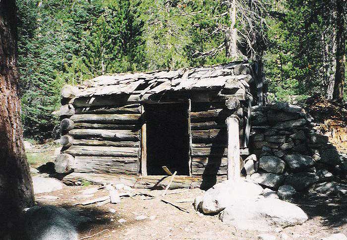
Not to worry, I was to meet Secor and Buehler at Shorty's Cabin and climb both peaks as a group (after my solo climbs of the very remote Kern Point and Picket Guard, but that's another story). RJ surely knew the way, so I didn't fret much about the multiple reports of "the guide book must be wrong" or "we didn't see any route". As you surely expect by now, they didn't show up at the cabin. Then again, the CABIN didn't show up at the cabin. It's on the map, but it's not on the ground. The terrain matched, the GPS matched, the cabin just isn't there. I spent half an hour crashing through dewy brush and grass, sure that as soon as I gave up they would whistle and jeer at me from some hidden spot. Nope. They showed up a couple of hours later, having not quite finished the 20-mile hike in the day before, and searched for over an hour (also in vain) before giving up on the cabin. NOTE: See notes at the bottom - as of 2008 the cabin DOES exist!
Meanwhile, muttering under my breath about the idiocy of remote rendezvous points, I headed for Whaleback alone. Cloud Canyon is nice after the first half mile, and anyone who says to stay on one side or the other of the stream must have been there when the stream was hard to cross. I crossed three or four times, finding slabs and tundra that made easy walking with almost no need for boulder hopping. Neither side is good the whole way.
Map of my APPROXIMATE route:
(I stayed west of the ridge on Whaleback, ignore the blue line entirely!)
At 9600', in Cloud Canyon, I sat down for a long read of the guidebook route and the map. Secor's 1st edition says to climb "through a prominent patch of grass and brush to a point about 1/4 mile south of the summit along the peaks's south ridge". The book is silent on what to do about the fact that the west face is, in this area, apparently a sheer cliff. My GPS confirmed where the peak was, and the point "1/4 mile south of the summit" was clearly JUST NORTH of a small saddle in the ridge. Perhaps that's why the 2nd edition says to climb in the trees that are further south, to avoid the cliffs, but that leads you to the ridge SOUTH of the saddle, too far from the peak, forcing you down the east face to avoid the 4th class ridge. (I didn't have the second edition at the time, and now I'm glad I didn't!) The 2nd edition, in fact, has you on the east face of the ridge for the southwest face route.
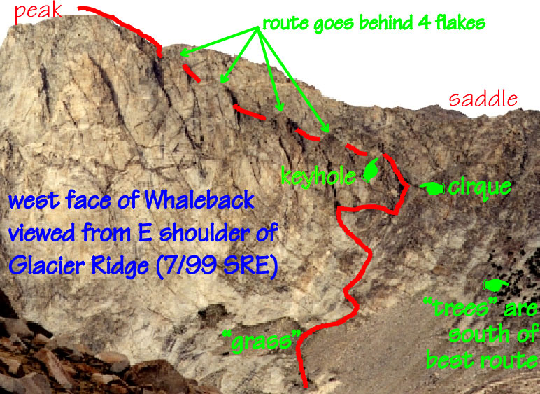
I noted the 1st edition said "grass" while Tidball's report mentioned "trees": Seeing that they lead to different places, and knowing that most groups (and even the AUTHOR) seem to think the guidebook is wrong, I studied the top of the "grassy knoll" (OK, "talus fan") for defects and clues. My hope was that the book suffered from under-specification (failing to mention "keep-out" places) and the other groups had suffered from over-assumption (matching the wrong place to start the route). One chunk of rock was a different color, and I reasoned that there might be an interface zone (ledge) behind it. The 7.5' topo showed a small bowl (cirque?) as a blip in the 11000' elevation line just below the saddle, but the slabs below it were to steep for comfort. I chickened out and cut left instead of climbing straight up into the cirque.
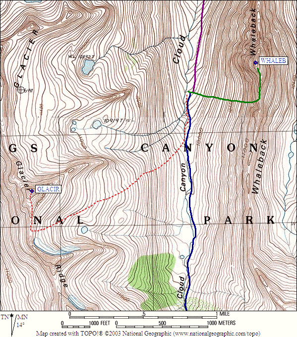
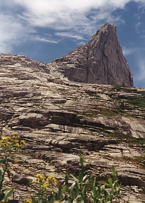
From the top of the grass (10600', just north of the cirque entrance), I followed a plant-filled (second class) crack in the slabs up and left, passing below a black water stain to the left of the now-obvious stain coming from the cirque. To my immense pleasure, a horizontal ledge ran south above the different colored rock I had noted and dropped (20' of low third class, where I left a duck for others to follow) around the corner into the cirque (11000'). Once in the cirque, the climbing returned to second class and the "cirque" turned out to be a chute which turned sharply north and climbed steeply to a keyhole in what I first thought was the south ridge of Whaleback. Nope. The keyhole is the ACTUALLY start of the west face ledge, and you can see the summit from the cirque through the keyhole!
Looking up through the keyhole, the summit is visible:
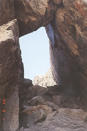
Long shot of the keyhole, from
Aaron Schuman's 2003 report:
"Now the Lord had prepared a great fish to swallow up Jonah. And Jonah was in the belly of the fish three days and three nights." I, on the other hand, was in the mini-cirque of Whaleback for only a few minutes before being discharged onto the ledge. If you don't enter the bowl or cirque, and if you don't exit it through a keyhole, you're somewhere else entirely.
The improbable west face ledge is mostly 2nd class, stays at least 100' below the summit ridge at all times, and goes up and down while basically making a beeline to the summit behind four huge flakes. As it rises and falls in small increments, it sometimes tilts toward the cliffs below and in one spot is hard-scrabble that threatens to send you sliding toward the edge (second class, but worth your full attention anyway). Eventually it is blocked by three chockstones, two of which are bypassed on the left (easy third class moves required), the last of which is distinctly triangular and a different color. It matches the blocks you can now see leading to the summit ridge, and requires about 10' of near-vertical climbing to bypass on the right. The holds are good, the exposure is near zero, and suddenly you're on the ridge 100' below the summit - 50 yards of blocky scrambling, and the summit whooping begins!
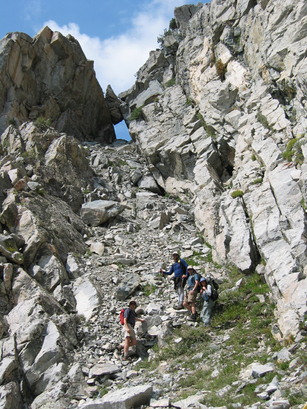
Back at the stream:
Perhaps the best part of finding this route was that I got to show it to Secor the same day. (RJ and Herb turned up down at the stream, where I spotted them after taking a quick dip.) Secor's NEXT edition should contain a picture with the route traced in. He was convinced that there wasn't actually a west face ledge (perhaps after reading prior SPS trip reports). Our little meeting-spot-problem served us both well: I got to explore, maybe even to re-discover a lost route (or at least one that has dropped out of the guide book), and they got instant beta for climbing it the next day.
Here's my Whaleback route picture, taken from the Glacier Ridge side of the valley:
The three of us enjoyed each other's company for the hike up Glacier Ridge, where we poked around for a while and eventually threw a rope over the summit block. (Take a half rope and just do a hip belay - no slings or other pro required for this relatively easy 4th class block.)
Glacier Ridge from an aesthetic angle (looking west):
We returned to their camp where Larry Hoak was hiding out from the bugs, chatting about the Sierra Club, religion, where to camp for Picket and Kern, etc. The next day I grunted out 20+ miles to my car (at the Marvin Pass trailhead, which I'll mention in my Picket/Kern report) while they headed over Colby Pass under tall thunderheads... I'm betting the weather held, and looking forward to their report on climbing the Milestone Basin peaks from the west side!
|
The cabin is located about where I have placed the tip of the flag
(not at the base of the flag pole - it's easier to see this way),
about 15-20 yards east of the trail. You will note the map
incorrectly places the cabin a little north of where it actually is,
unless the placement of the trail is incorrect. I don't recall if
the cabin is north, south, or directly west of the creek junction of
the tributary coming from Colby Lake.
When heading south from Big Wet Meadow the trail crosses the creek over to the west side of the creek and then later crosses the creek again to the east side. The cabin is between these two crossings, east of the trail, between the trail and the creek. There is a very low rise between the cabin and the trail, which obscures the view of the cabin from the trail. I don't remember there being a side trail to the cabin, which is probably why many people who are looking for it miss it. I don't recall if the cabin is north, south, or directly west of the creek junction of the tributary coming from Colby Lake. | 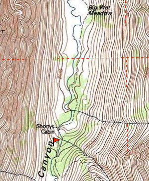
|
photo by Prapanna Smith
Debbie Bulger adds two photos and a waypoint for the cabin as of 2014:
Cindy, the ranger at Roaring River, told us the cabin had been carefully disassembled and restored in the fall of 2012. It sported a new shake roof crafted on site as well as other repairs.
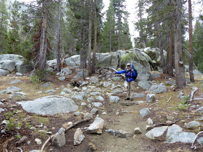
Below is a photo of me from Aug, 2013. The photo is looking south toward Cloud Canyon (uphill).
I am pointing to the turnoff spot for Shorty's cabin. The cabin is just a short distance from
the trail.
And here's the cabin! It is not visible from below hiking up.
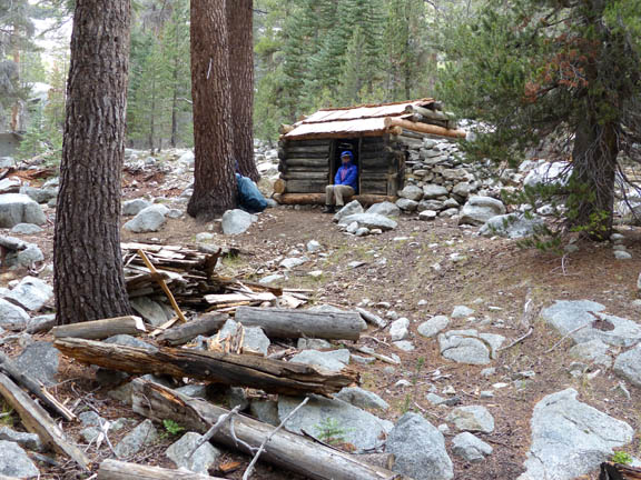
FYI, Shorty's cabin is at N 36 38' 49.4" / W 118 32' 05.3"