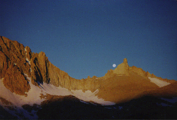

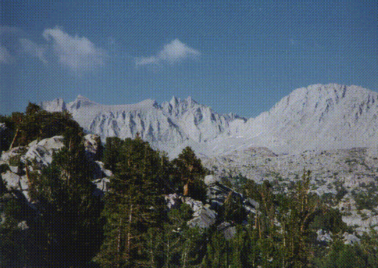

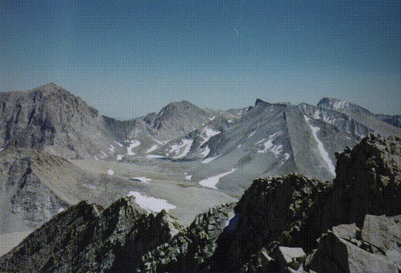
After several days of arduous hiking over Shepherd's Pass our party of twelve reached the Upper Kern for a week of climbing. This spectacular part of Sequoia National Park is surrounded by the 13,600' Great Western Divide to the west, the 13,900' Kings-Kern Divide to the north, and the 14,000'+ main Sierra Crest to the east, and is often considered to be the wildest and most scenic part of the Sierra. From our high camp at 11,500' in Milestone Basin we had a wonderful view of Milestone, Midway, and Table Mountains directly behind us and across the Kern canyon we could see Tyndall, Williamson, Barnard, Russell and Whitney. At twilight on our first evening at the Milestone camp, after a late afternoon thunderstorm had cleared the air, we enjoyed a full moonrise over the Whitney crest.
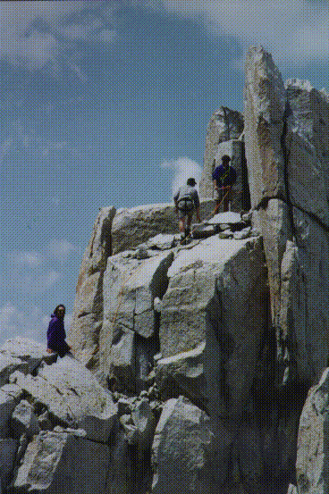
On the first climbing day we could barely contain our excitement to start climbing and at dawn after a magnificent sunrise with the moon setting over Milestone Mountain, we set out for Table Mountain (13,630'). Our first challenge was to locate the correct route on the broken south face of the peak. After quickly climbing up several sandy ledge systems we reached the crux of the climb which was a ten-foot boulder that we climbed on the right side with an awkward class 3 move around an exposed corner and up to the next ledge system. Once around this problem, we soon came to what was to be the most frightening situation of the day. Near the top of the south face was a large chute blocked by a huge chockstone that was easily climbed by going under and behind it. As the first climbers waited on top of the chockstone, a huge slab under their feet suddenly shifted while David Harris was directly underneath. Fortunately the slab didn't really fall but only shifted on top of the chockstone. After catching our breath over this close call, we quickly finished climbing the face and reached the summit plateau. After climbing the maze of ledges and chutes, the summit of Table Mountain is an amazing contrast. It's a large plateau measuring about 300 by 800 yards that is gently inclined northwards towards the summit rocks which overlook the north and west faces of the peak. After a leisurely summit break in perfect cloudless and windless conditions, we made our descent down the route that we had ascended and traversed across the talus filled basin at the base of the mountain to the next peak of the day, Midway Mountain. At 13,666', Midway is the high point of the Great Western Divide. Our route up the north side of the East Ridge was just a long slog up talus and sandy slopes to the summit rocks. After lunch we descended the ascent route to the 12,600' level where we climbed through a notch in the East Ridge to traverse over to the final ascent of the day, Milestone Mountain (13,641'). At this point since I had previously climbed this peak, I decided to take the rest of the afternoon off and returned to camp to enjoy a dip in the lake and a quiet afternoon reading in the shade of a nearby whitebark pine. Several hours later Steve Eckert, David Harris, Bob Suzuki, Craig Clarence and Steve Shields returned, quite happy at climbing all three of the major Milestone Basin peaks on the first climbing day.
On the next morning the group that had climbed the Milestone peaks the day before, decided to move our camp a few miles around the corner to the north and to attempt Thunder Mountain (13,588'). After quickly descending the Milestone creek trail in clouds of mosquitoes, we ascended along the Kern river to drop our packs at a small, unnamed lake near treeline on the Kern headwaters. We soon secured our food and headed off to climb Thunder. The approach up the glaciated stair- step valley between Table and Thunder mountains proceeded quickly and we soon arrived at Lake 12,280' just below Thunder Mountain where we filled our water bottles and had a brief lunch. The climb became increasingly difficult as the talus became larger and more unstable and we spread out to avoid any possible rockfall problems. After a short bit of interesting class 3 climbing we soon reached the south summit of the peak and got a big surprise. Between the south and the north summits, the route was quite exposed with a short twenty foot down climb to a notch and then a traverse along a narrow ledge below numerous large, loose vertical flakes and to a thirty foot climb up cracks and faces to the summit tower. After evaluating our situation, several of us decided that the available 7mm rope didn't offer much more than a psychological belay for the class 4 traverse and decided to be content with only climbing the south summit. After cautiously making the exposed traverse Steve Eckert, Steve Shields and Craig Clarence reached the north summit and safely returned to the rejoin the rest of us watching from the south summit. The descent back to our camp went quickly. Just before dusk the rest of the group that had climbed Table Mountain earlier that day arrived at camp.
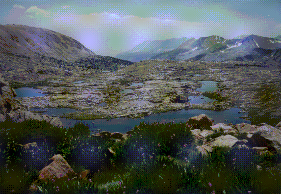
The next morning while the group headed off to climb Mt Jordan and Genevra, I headed off to climb Mt Ericsson (13,608') which had eluded me for several years. After a review of the guidebook the night before I realized that today's date of August 1, 1996 was exactly 100 years after the first ascent by one of the Sierra's most famous climbing couples, Bolton and Lucy Brown. With that interesting bit of trivia in mind I took my time and enjoyed climbing the West Ridge route from Lucy's Foot Pass and reached the summit in a few hours. The last 100 feet of climbing the summit tower was moderately challenging class 3 and I enjoyed a brief lunch in perfect weather before descending the same route. Since I had plenty of time I lazily wandered among the several dozen small tarns and lakes that make up the headwaters of the Kern River before heading back to camp. Shortly before dark the Jordan and Genevra team returned tired but satisfied and we talked about our adventures of the day and planned the rest of the trip.
Early the next morning Steve Eckert and I set off to move our camp to the base of Diamond Mesa so that we could climb Junction Peak that day and Barnard and Trojan on our last day. After setting up camp in a sandy flat at about 11,500', we headed up a short section of loose talus to gain the gentle slope of Diamond Mesa. A moderate trudge up the decomposed granite slope soon brought us to the knife-edge ridge between the Mesa and Junction Peak (13,888'). An airy but easy traverse quickly got us to the main summit mass which we climbed first on the east side, then the south and finally on the west side of the class 3 south ridge. Although not especially difficult the route was not obvious or straight forward. After a short down climb just below the summit on the west side to avoid a short exposed knife edge, we climbed the summit by an interesting route up the south face. Due to it's position at the junction of the Kings Kern Divide and the main Sierra crest, Junction Peak has extensive views of all of Sequoia and Kings Canyon backcountry from Kern and Florence peaks on the southern horizon, down the 10,000' eastern escarpment to Owens Valley, to the Palisades and Evolution crests on the north. After a short break in the perfect warm and windless conditions we descended the south side of the West Ridge to Ski Mountaineer's Pass (13,120'). The south side of this pass is about 500 feet of moderately angled scree that allowed us to quickly descend to pick up the Muir Trail just below the cliffs headed up to Forester Pass. A rapid descend down the trail brought us back to camp in time to enjoy a dip in the creek before we enjoyed a Happy Hour with Margaritas and chips before dinner. Just after sunset, David Harris and Steve Shields wandered into our camp to join us after having climbed both Ericsson and Stanford by the South Ridge routes earlier that day.
At dawn the next morning David Harris, Steve Eckert and I headed out over Wright's Lake Col (12,000') for the approach to Mt Barnard (13,990'). A quick traverse of the beautiful Wright's Lake basin brought us to the headwall below the north side of the northwest ridge of the peak. A few interesting moves on the slabs and short cliffs of the headwall got us on to the scree and boulders of the west slope of the peak, which we quickly ascended to the summit. After a brief lunch stop in cold and windy conditions, we descended the east bowl about 700' and traversed over to the saddle at the base of the west slope of Trojan Peak (13,950'). We quickly climbed to the summit and enjoyed great views nearby of Mt Williamson and Tyndall and the ice bound lakes of Williamson Bowl. Retracing our route down to the saddle between Barnard and Trojan, we decided to descend the chute below the saddle. A previous SPS trip report had indicated that this route offered a quick descent down a loose talus chute. After carefully avoiding setting off any rockslides we descended the loose 1,200' chute and soon reached a string of beautiful small alpine lakes that make up upper Wright's Lake basin. We quickly traversed across the basin and ascended Wright's Lake Col back to camp. After breaking camp we met the rest of the group at Shepherd Pass (12,000') at 6pm where most of the party spent the night while a few of us continued down to Anvil Camp to enjoy warmer conditions. Early the next morning we descended back to the trailhead and headed home.
In all our group of twelve; Kelly Maas, Bob Suzuki, Aaron Schuman, Debbie Benham, Debbie Bulger, David Harris, Steve Shields, Steve Eckert, Charles Schafer, Andy Skumanich, Craig Clarence and the author of this report, John Bees, had a wonderfully successful climbing trip in the heart of Sequoia National Park backcountry, having safely and successfully climbed fourteen peaks in a week.
Be sure to read Aaron Schuman's Climb-O-Rama report on the same trip.