Sage Flat
(Standard Approach for Olancha Peak)
Revised 8 Sep 2013 - please send updates to the webmaster
From US 395, turn west on Sage Flat Road (waypoint SAGEFJ), which is marked with yellow intersection sign. This intersection is 19.5 miles north of Little Lake or 5 miles south of Olancha (waypoint OLANCH). There is a cell tower between Hwy 395 and to the trailhead so you should have a good signal at your car and perhaps all the way to Olancha Pass.
Follow the pavement past the houses until the road narrows and enters some trees. Shortly after that the paved road becomes dirt 3.2 mi from Hwy 395 (waypoint SAGEPR), continuing to the trailhead as very a good dirt road suitable for any vehicle. Take the right fork at the second Sierra Glen Ranch sign (waypoint SAGEF1), then take another right fork (waypoint SAGEF2) near the trailhead, staying on the better road each time.
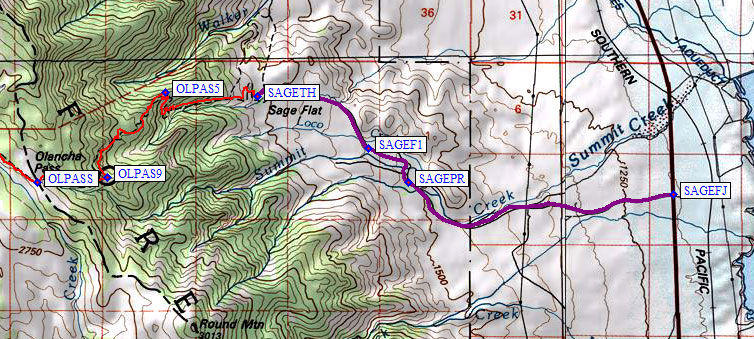
Parking is loosely centralized around a main dirt lot 5.5 mi from Hwy 395. Uphill from this lot there is a corral, which you want to stay south (left) of. Uphill from the corral there is an old (forest service toolshed?) building that used to be labelled as Bldg No 85. Horse trailers use the area next to this building so don't park there.
The Olancha Pass trailhead sign (waypoint SAGETH, 5.8k) is uphill from this building, not visible until you are past the corral! There are nice places to camp in the oak trees that surround the trailhead, and an intermittent stream (don't depend on using it for drinking water). There is a box with a clipboard at the trailhead, and a Pacific Crest Trail sign. Signing in there may be the only permit requirement for the Olancha area, but check with the Lone Pine rangers first.
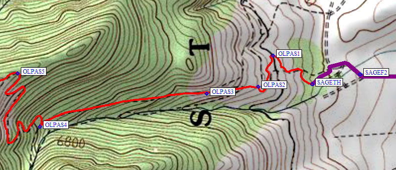
The trail to Olancha Pass does NOT always follow the line on the USGS maps. Pay attention on your way up so you don't make a wrong turn on the way down. The main trail (there are lots of cattle and use trails) goes northwest to waypoint OLPAS1, then south before joining a livestock trail at OLPAS2 and turning west along a wire fence. Be sure to follow that fence on the way down, turning right (at OLPAS2, 6.1k) when the fence stops. There are no signs directing you. This part of the trail map is a GPS track log I collected in 2011.
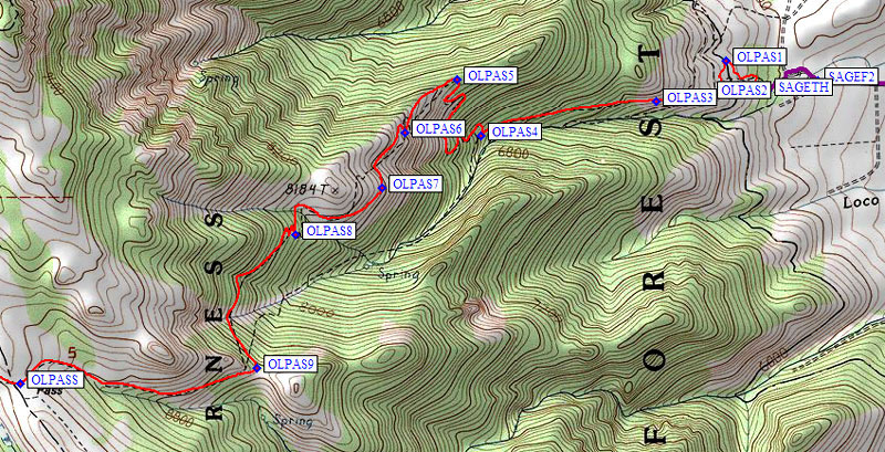
The trail continues up the north side of the drainage, through a steel gate (waypoint OLPAS3) and eventually to a junction with the old cattle driving route. At waypoint OLPAS4, 1.1 miles from the trailhead, there is a sign directing hikers and horses up to the ridge. A so-called 'cattle driveway' stays near the stream, and looks shorter but is not maintained so erosion and neglect have erased portions of it.
The trail switchbacks north to the ridgeline (waypoint OLPAS5, 7.3k) where there are some great campsites 100' east of the trail corner. Above this the trail mostly follows the line on the map, but not always! I've corrected portions I'm sure of, much of the rest is not quite right. In winter the final traverse to the saddle at OLPAS9 can be tricky. It's in the tall trees with a lot of snow, so the trail won't be visible and there'll be a steep side slope. The trail does not cross where the map shows it, and I didn't see a sign for the cattle trail in March, but in the summer you can probably find one.
Over Olancha Pass proper (waypoint OLPASS, 9.2k) and along Summit Meadow the slope is minimal and other than bugs there are no obstacles.
Useful Links: