Canebrake Road Trailheads
Revised 9 May 2014 - please send updates to the webmaster
For another way to climb Spanish Needle, see Rodecker Flat / Sand Canyon trailhead
Canebrake Road gives access to Sawtooth (S), Spanish Needle,
and Lamont Peak from Hwy 178 or Kennedy Meadow (S). It is a
high quality graded dirt road, suitable for year round use by
ordinary passenger vehicles.
|
NOTES:
|
|
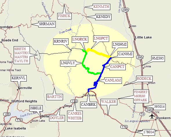
Map of trailheads and junctions mentioned below:
Nine Mile Canyon Road connects Hwy 395 (waypoint 3959MI) to Kennedy Meadows (waypoint KENEDY). Roughly halfway (12 miles from each end) there is a major intersection with a Chimney Peak Rec Area monument but nothing that says what road it is (waypoint CAN9MI). This would be the northern end of Canebrake Road, which may be called Chimney Basin Road between here and the Chimney Creek Campground (waypoint CHMCMP). Nine Mile Canyon Road is usually plowed in the winter, but Canebrake and the Sherman Pass Road beyond Kennedy Meadows are not.
Hwy 178 connects Hwy 395 to Hwy 99 in Bakersfield, by way of Hwy 14, Walker Pass, and Lake Isabella. The southern end of Canebrake Road is at Highway 178, about 9 miles west of Walker Pass, or about 25 miles east of Lake Isabella. The turnoff isn't marked with the road name, but there is a big sign for the Chimney Peak BLM wilderness area. The first few yards of the road are paved, and it's one of very few paved turnoffs along the upper reaches of Walker Pass Highway.
Canebrake Road doesn't technically go all the way to Nine Mile Canyon Road, but Chimney Basin road fills in the gap and most people don't know the difference. It's about 15 miles from Hwy 178 to Nine Mile Canyon.
As of 2005 the Long Valley Loop Road was CLOSED permanently at the north end (on Nine Mile Canyon Road at waypoint LNG9MI) and when approaching this section from the south the road basically ended (without a sign or gate) about a mile south of the PCT at the head of Long Valley. As of 2010 Doug Hoffman reported that the western portion of the road in yellow on the map below was passable with 4WD. In 2010 the road was open all the way. The road which may or may not be open is in yellow on the map above.
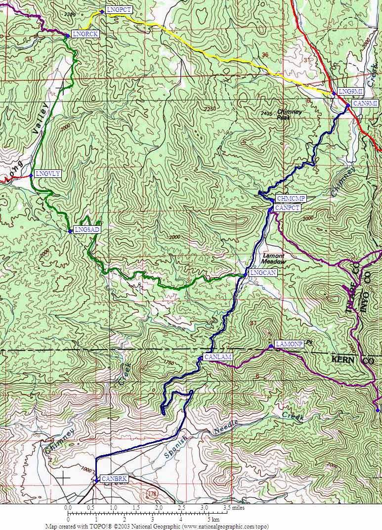
Whether or not the northern end is open, the southern end of the loop is a very good dirt road suitable for all cars (see GPS Route LONG VALLEY). Turn west from Canebrake Road at the sign for Long Valley (a yellow Y intersection sign at waypoint LNGCAN). The signs say 11 miles or 15 miles, but don't bet on that. It's best to have a GPS set to find waypoint LNGRCK - in 2005 my hiking partner drove north past this trailhead on Long Valley Loop Road and almost got his Jeep stuck in the mud that followed. Doug, 5 years later, drove past the still-unmarked gate but didn't find such a bad road.
To find the trailhead at LNGRCK, watch for a small (seasonal) stream crossing the road just north of a large parking lot west of the road (Jim Morford says 8 vehicles could fit here). Locate the massive brown steel gate on your left (west) and walk down the road behind it. Note that there is no sign for this gate or the trail - nothing at all to indicate the Long Valley Road is ending or where you should park or where the trail is!
A decade ago you could drive almost down to the Kern River, but the side road going down is now gated at the LNGRCK junction (about 6800') so it's a 2.5 mile climb back up from old trailhead to your car on the way out. From the trailhead, walk downhill past the trailhead Jenkins describes and keep left at a junction (waypoint KRNJCT) to reach a "reasonable" place to cross the Kern River (waypoint KRNRIV). There may be a fallen log here, or you may be chest deep in springtime rapids. The first time I tried to cross, we deemed it to dangerous even with a climbing rope and gear. Others have made it by swimming. Use caution!
From the current trailhead it's 5 miles and 1300' down to the Kern River, and the trail from the Kern up to Rockhouse is basically gone - it's a good cross-country route where you'll see bits of a trail occasionally.) See the Rockhouse Traverse trip report for more details (including detailed maps) on this challenging and rewarding route. You can also just leave the trail and follow near the river, as it's easy to go cross-country in the desert vegetation.
Doug adds: "The Rockhouse Basin trailhead is for Stegosaurus Fin in addition to Rockhouse. Stegosaurus is an incredible peak and worth the extensive effort to get there, but not many people know about it because it's so remote and hardly mentioned anywhere (I saw it on summitpost). It's a very prominent peak in the area the summit block is likely the best class 4 summit in the area. It well deserves mention on the page. LNGRCK is the closest trailhead for this peak as well."
Useful Links: