Rush Creek And Fern Creek Trailheads
Revised 11 Jun 2012 - please send updates to the webmaster
|
Fern Creek can apparently be used as a winter or summer trailhead to
climb San Joaquin from the north (a more challenging climb than the
standard route from Minaret Summit). There appears to be no trailhead
parking at Fern Creek (waypoint FERNTH). Since I haven't used this
trail, that's all the description I can provide! Please send details
if you have them.
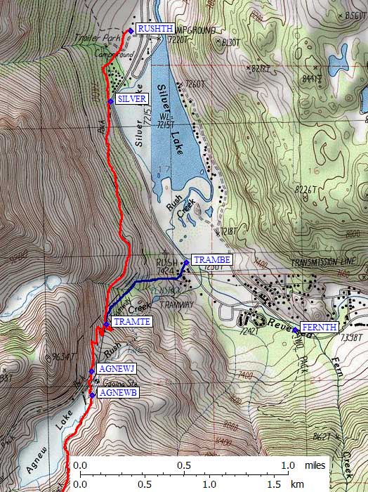
The Rush Creek Trail (waypoint RUSHTH) can be used to access Davis, Ritter, Banner, Koip, and other destinations such as Thousand Island Lakes or Parker Pass. Rush Creek is also a popular ice climbing spot in the winter, because water flows year round over cliffs that don't get much sun. This trail sidehills 1.5 miles south to the top of the Edison tram, running almost level at times. It appears to be exactly the same mileage to Thousand Island Lake as the trail from Agnew Meadow, but the Agnew Meadow trail has about HALF the round trip elevation gain! There's an illegal route from the Edison power plant (waypoint TRAMBE) which generates electricity from Rush Creek. In winter there have been tracks up the tram rails. These people started by crossing the Edison employee parking lot and going between the two high-voltage structures! A sign there says "WARNING! Heavy construction. No trespassing. Stay clear of track and cable. Use trail at all times." Of course, there is no trailhead here. (See SILVER and RUSHTH, about a mile north.) The tram intersects the trail about half a mile from the Edison plant. No one I know has used it, but there's a trail from the Rush Creek trailhead (RUSHTH) to Parker Pass. The sign is easy to miss, the intersection is only a few yards from the campground host / closed public restroom. The Parker Pass sign is easier to see on the way OUT than it is on the way IN. | |
|
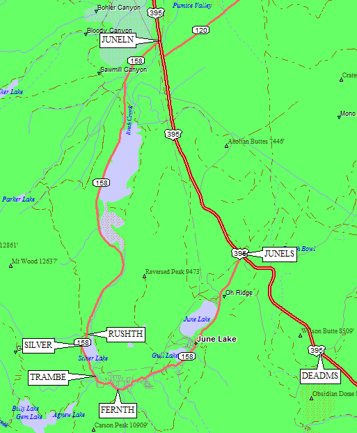
These three trailheads are accessible from the June Lake Loop (Hwy 158)
just north of Mammoth Lakes. Leave Hwy 395 at waypoint JUNELN or JUNELS
for the northern or southern part of the loop. The northern part of the
loop is gated near Hwy 395 when there is snow on the ground, but we once
found (Dec 1998) a plowed path around the gate and hardpack snow suitable
for 2WD sedans. The southern part of the loop goes through the town of June Lake,
past the ski resort, and past the Fern Creek trailhead (waypoint FERNTH) before
dead-ending at milepost 6 (waypoint TRAMBE) at the Edison power plant. In the
summer, you can continue about 3 miles north to Silver Lake (waypoint SILVER)
and then to the Rush Creek Trailhead (waypoint RUSHTH).
Parking in winter is a problem! The southern loop from June Lake is blocked seasonally at the bottom of the Edison tram (waypoint TRAMBE). The entire northern loop is also blocked seasonally. If you try to access Rush Creek in the winter via the southern loop, you'll probably end up parking somewhere they don't want you to. One winter we parked along the plowed road beside the Edison plant (waypoint TRAMBE), where others parked also, but received warning tickets for blocking the roadway. Apparently day use is ignored, but overnight use isn't?? Not sure what would happen if you parked by Fern Creek, but there were no SnoPark signs. During summer, the official Rush Creek Trailhead (waypoint RUSHTH) is nestled between RV campgrounds, next to a closed public toilet and a campground host's RV. When the campgrounds aren't open for fishermen, the trailhead may be closed also. The trail goes behind the campground without gaining much elevation, and can also be accessed near Silver Lake (waypoint SILVER) where there is roadside parking used by fishermen but perhaps not legal for overnight parking. However you get to the point where the trail and the tram intersect, (waypoint TRAMTE) the trail switchbacks up at a gentle grade and the tram goes up more steeply (and therefore is shorter). The trail intersects the tram twice for all climbers, and a third time for those headed across the outlet of Agnew Lake toward Thousand Island Lake. The trail junction (waypoint AGNEWJ) is well marked IF you're on the trail, but if you're hiking on the tram route you'll never see the sign. It's above the tram near the steel stairs described below. |
|
If you're headed for Agnew Pass, Thousand Island Lake, etc, look for steel stairs leading down from the tram to a small building. Ignore the building and any use trails, head for the huge pipeline between you and the lake. Once you cross the pipeline (partially buried) you should be able to see the footbridge across the outlet stream (waypoint AGNEWB). That's where the trail starts around the east shore of Agnew Lake. It's not well maintained, and there are lots of use trails, but don't climb too far above the lake until you've walked around the shoulder and can see the bowl south of the lake.
Useful Links: