Ruby Mountains
Revised 6 Mar 2014 - please send updates to the webmaster
For either trailhead, start in downtown Elko. The highway signs will direct you to the eastern Elko exit, where there are huge hotels and casinos and very expensive gas. The western Elko exit is closer to the old downtown for shopping and eating. The main drag through town is Idaho St (aka Business I-80), from which you can turn southeast on either 5th (at waypoint ELKONV) or 12th to reach the trailheads described below. 5th turns into Hwy 227 (aka Lamoille Highway), which bends northeast and intersects 12th at waypoint 227J12. Stay on 227 as it bends back to the southeast and goes through Spring Creek on its way to Lamoille Canyon and Hennen Canyon.
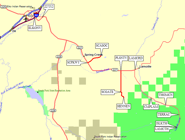
In 2002, we got a cheap room in Elko NV and treated ourselves to a huge (but good) $5 breakfast at the cafe on Idaho and 13th. Looks like a dive, so put on your polyester and pretend you're a time traveller. The guide book lists outdoor stores in Elko, but they've all closed. Unless you want to buy a gun or a fishing pole, you're out of luck. We still wanted a map, however, and the Forest Service office directed us to The Map House, (at 405 Court St, call 775-738-3108) which sells USGS topos and a local guide book. Look for the big copper dome of the courthouse as you drive down the main drag (Business 80, aka Idaho St), and jog one block over to Court St. They had a locally printed guide book, which looked OK but had conflicting distances and elevation gains.
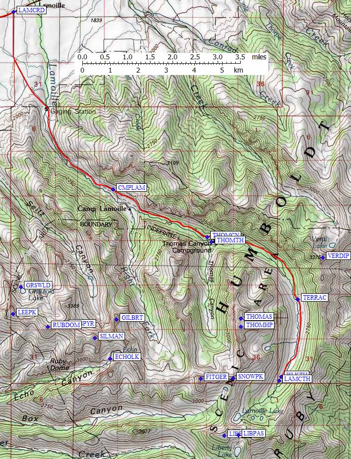
Lamoille Canyon - See GPS Route LAMOILLE CYN.
If you're headed to Lamoille Canyon, stay on Hwy 227 (aka Lamoille Hwy),
continuing straight past Spring Creek Parkway (waypoint SCPKWY) and Pleasant Valley Road
(waypoint PLSNTV). Do NOT take Lower Lamoille turnoff, stay on 227 up the hill! (My
car's GPS wanted me to go that way, and it turns into a 4WD road before connecting
at waypoint PLSNTV.) Turn right (south) from 227 on Lamoille Canyon
Road (waypoint LAMCRD,
at a sign pointing to Lamoille Canyon). Above this the road narrows and climbs between steep canyon walls.
At the Right Fork of Lamoille Creek, you'll see Camp Lamoille to the south
(waypoint CMPLAM). There is an unimproved parking area outside this permanent camp,
but I think you have to walk through the camp to get to the vague use trail which
leads up the Right Fork. I left a car here and hiked up Thomas Canyon, then down
Right Fork, and ended up wading the stream near the entrance to the camp. There must
be a better way - if anyone knows for sure, please let me know!
The next junction you come to is Thomas Canyon (waypoint THOMCN, where there is a
fee campground and a trailhead. The campground has running water and pit toilets.
This is the only drive-in campground I'm aware of anywhere in the Ruby Mountains.
Again, if someone knows better, please send details! The trail up Thomas Canyon
starts at the south edge of the campground (waypoint THOMTH) and is easy to miss
if you're not expecting it. Thomas Canyon has a nice trail for a mile or so, but
the stunning upper basin (at 9500 feet) involves some serious cross country travel.
The pullout at Terraces (waypoint TERRAC - a campground that is no longer in use?)
is the first real view of the rugged peaks in Upper Lamoille Canyon. Above there
photographers will want to make frequent stops. The road ends in a parking lot
that handles bus tours. The trail to Island Lake (waypoint ISLKTH) starts just
north of the loop and traverses into a great cirque from which you can climb
Thomas by a route that barely stays Class 2. (Note that the high point of Thomas
is not the named summit.) The main trail starts at the south end of the parking loop
(waypoint LAMCTH) and continues south up Lamoille Canyon to Liberty Pass.
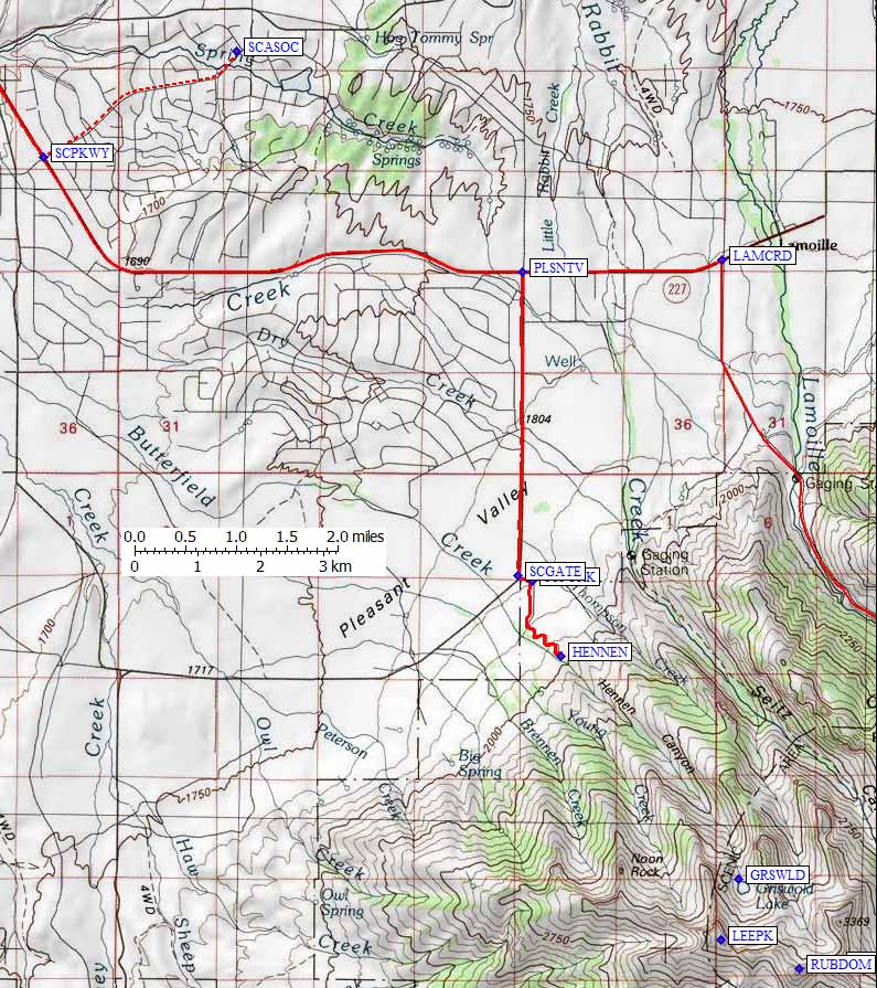
Hennen Canyon - See GPS Route HENNEN CYN.
See my 2002 trip report
for how to climb Ruby Dome (waypoint RUBDOM) from this trailhead.
Note that Butterfield Creek drains Griswold Lake (waypoint GRSWLD)
in Hennen Canyon. It seems like just one name would have worked!
If you're headed to Hennen Canyon, take Hwy 227 out of Elko as described
above. About 12 miles from where you left Idaho St, you'll see
Spring Creek Parkway (waypoint SCPKWY) near a fire station sign,
a school sign, a crosswalk, and a reduced speed limit (hard to miss).
If you don't mind hiking a bit more and just leaving your car by the
side of a dirt road, drive right past this turnoff and save some money.
If you want to save a bit of hiking, and get your car off the "main"
road, you can get a key to the Spring Creek Campground and park in a
campsite while climbing. It's $10 per person per day, plus a $25
deposit, so don't take everyone into the office or you'll get reamed!
You can call them at 775-753-6295, or mail a letter to 451 Spring Creek
Parkway, Spring Creek, NV 89815. To get the key, Mon-Fri only, take
Spring Creek Parkway northeast from 227 (waypoint SCPKWY) almost 3
miles. After the Morman church, the filling station, and the ice cream
store, you'll see the Spring Creek Association building on your left
(waypoint SCASOC). Give them some money, be clear on how to return the
key, and head back out to Hwy 227.
SR-227 bends due east, and 17 miles from 5th and Idaho you turn south
and leave the pavement at Pleasant Valley Road (waypoint PLSNTV).
After 3 miles, this good dirt road bends right, and at the corner you
see the gate for the Spring Creek Campground (waypoint SCGATE). You can
apparently park here, but the local we ran into wasn't sure if it was
legal. If you got the key to the gate as described above, let yourself
in and save 1.2 miles and 450' of gain by driving to the turnaround at
the highest campsite. There is only one fork in the road (waypoint SCFORK)
and you turn right before going up a set of switchbacks to the trailhead.
Since we were paying $40 for the privilege, we took the highest campsite
(waypoint HENNEN). It was littered with trash, and part of the picnic
table appears to have been used for firewood. Still, it saves some
walking to drive up here, and this is where the trail starts.
Prior reports mention a sign at the trailhead, but we saw none. There is
a large turnaround area (for horse trailers), but the use trail up
Hennen seems to start directly from the highest campsite. There is a
small stream on each side of the campsite, but head directly northeast
from the picnic table and you'll find a place to ford. Or you can walk
southeast and go through a gate and THEN go left to another ford. I
managed to keep my boots dry in both directions, but it's tricky. Just
get to the left side of all streams as soon as you can, and you'll pick
up a good use trail that climbs a couple dozen yards away from the trees
in open sage.
Useful Links: